Students can access the CBSE Sample Papers for Class 12 Geography with Solutions and marking scheme Term 2 Set 10 will help students in understanding the difficulty level of the exam.
CBSE Sample Papers for Class 12 Geography Term 2 Set 10 with Solutions
Time Allowed: 2 Hours
Maximum Marks: 35
Roll No. ___________
General Instructions:
- Question paper is divided into 5 sections A, B, C, D & E
- In section A, question number 1 to 3 are Very Short Answer type questions. Attempt any 3 questions.
- In section B, question number 4 is Source based question.
- In section C, question number 5 & 6 are Short Answer type questions.
- In section D, question number 7 to 9 are Long Answer type questions.
- In section E, question number 10 is a Map based question.
Section – A
Very Short Answer Questions
Question 1.
State about high technology industries. (2)
Or
Identify some main characteristics of high technology industries.
Answer:
High technology, or simply high-tech, is the latest generation of manufacturing activities. It is best understood as the application of intensive Research and Development (R and D) efforts leading to the manufacture of products of an advanced scientific and engineering character.
Or
Some main characteristics of high technology industries are
- Neatly spaced, low, modern, dispersed, office-plant-lab buildings rather than massive assembly structures, factories and storage areas mark the high-tech industrial landscape.
- Planned business parks for high-tech start-ups have become part of regional and local development schemes.
Question 2.
State about Cape of Good Hope Sea route. (2)
Answer:
Cape of Good Hope sea route connects the highly industrialised Western European region with West Africa, South Africa, South-East Asia and the commercial agriculture and livestock economies of Australia and New Zealand. The volume of trade and traffic between both East and West Africa is on the increase due to the development of the rich natural resources such as gold, diamond, copper, tin, groundnut oil palm, coffee and fruits.
![]()
Question 3.
State any two advantages observed in agriculture of Rajasthan after the introduction of canal irrigation. (2)
Answer:
The advantages observed in agriculture of Rajasthan after the introduction of canal irrigation are
- Introduction of canal irrigation has brought about a perceptible transformation in the agricultural economy of the region of Rajasthan.
- The traditional crops sown in the area, gram, bajra and jowar have been replaced by wheat, cotton, groundnut and rice.
Section – B
Source Based Question
Question 4.
Read the source given below and answer the following questions by choosing the correct option India, which has a predominance of rural population (approximately 69 per cent of the total population in 2011) and where villages were considered the ideal republics by Mahatma Gandhi, most of the rural areas are still poor performing primary activities.
Here most of the villages exist as appendix to the core urban centre forming its hinterland. This may give an impression that urban centres exist as undifferentiated homogeneous entities in opposition to the rural areas. On the contrary, urban centres in India are more differentiated in terms of the socio-economic, politico-cultural and other indicators of development than any other areas.
At the top, there are farm houses and high income group localities characterised by well-developed urban infrastructures, like wide roads, streetlights, water and sanitation facilities, lawns, well-developed green belt, parks, playgrounds and provisions for individual security and right to privacy. At the other extreme of it are the slums, jhuggi-jhopari clusters and colonies of shanty structures.
These are inhabited by those people who were forced to migrate from the rural areas to these urban centres in search of livelihood but could not afford proper housing due to high rent and high costs of land. They occupy environmentally incompatible and degraded areas. Slums are residential areas of the least choice, dilapidated houses, poor hygienic conditions, poor ventilation, lack of basic amenities, like drinking water, light and toilet facilities, etc.
Open defecation, unregulated drainage system and overcrowded narrow street patterns are serious health and socio environmental hazards. Moreover, most of the slum population works in low-paid, high risk-prone, unorganised sectors of the urban economy.
Consequently, they are the undernourished, prone to different types of diseases and illness. Moreover, most of the slum population works in low-paid, high risk-prone, unorganised sectors of the urban economy. Consequently they are the undernourished, prone to different types of diseases and illness.
(i) Socio-economic and politico-cultural indicators that are common in developed localities are usually found in which set up? (1)
Answer:
Socio-economic and politico-cultural indicators that are common in developed localities are usually found in urban set up.
(ii) Well-developed infrastructures, like wide roads, streetlights, water and sanitation facilities, lawns, well-developed green belt, parks, playgrounds are generally present in which places? (1)
Answer:
Well-developed infrastructures like wide roads, streetlights, water and sanitation facilities, lawn, well-developed green belt, parks, playgrounds are generally present in high income group localities and urban centres.
(iii) What are the features which characterise slum population? (1)
Answer:
The features which characterise slum population are low income, high risk and disease prone environment.
![]()
Section – C
Short Answer Questions
Question 5.
Explain the evolution of land transport in the world. Or Describe the Trans-Canadian railways. (3)
Answer:
Land transport includes the rail and road transports. It includes movement of people and cargo over short and long distances. The revolution in land transport came about only after the invention of the steam engine in the eighteenth century. Perhaps the first public railway line was opened in 1825 between Stockton and Darlington in Northern England and then onwards, railways became the most popular and fastest form of transport in the nineteenth century.
It opened up continental interiors for commercial grain farming, mining and manufacturing in USA. The invention of the internal combustion engine revolutionised road transport in terms of road quality and vehicles (motor cars and trucks) plying over them. Among the newer developments in land transportation are pipelines, ropeways and cableways. Liquids like mineral oil, water, sludge and sewers are transported by pipelines. The great freight carriers are the railways, ocean vessels, barges, boats and motor trucks and pipelines.
Or
The Trans-Canadian railways is a 7,050 km long rail-line in Canada which runs from Halifax in the east to Vancouver on the Pacific Coast passing through Montreal, Ottawa, Winnipeg and Calgary (Fig. 8.6). It was constructed in 1886, initially as part of an agreement to make British Columbia on the west coast join the Federation of States.
Later on, it gained economic significance because it connected the Quebec-Montreal Industrial Region with the wheat belt of the Prairie Region and the Coniferous Forest region in the north. Thus, each of these regions became complementary to the other. A loop line from Winnipeg to Thunder Bay (Lake Superior) connects this rail-line with one of the important waterways of the world. This line is the economic artery of Canada. Wheat and meat are the important exports on this route.
![]()
Question 6.
How is conservation of minerals an important aspect of sustainable development? (3)
Answer:
Resource conservation by limiting use and recycling/reuse is critical for ensuring availability of resources and sustainable development. Conservation of minerals is important because traditional methods of resource use result into generating enormous quantity of waste as well as create other environmental problems.
Sustainable development requires protection of resources for the future generations. The alternative energy sources like solar power, wind, wave, geothermal energy are inexhaustible resource. These should be developed to replace the exhaustible resources. In case of metallic minerals, use of scrap metals will enable recycling of metals. Use of scrap is specially significant in metals like copper, lead and zinc in which India’s reserves are meagre.
Section – D
Long Answer Questions
Question 7.
Discuss about ‘services’ as a tertiary activity. (5)
Or
State some of the commonly engaged tourist destinations with relevant examples and underlying factors for selection of these destinations.
Answer:
Services are an important tertiary activity which occur at many different levels. Some services are geared to the industry, some to people, and some to both industry and people, e.g. the transport systems. Low-order services, such as grocery shops and laundries, are more common and widespread than high-order services or more specialised ones like those of accountants, consultants and physicians.
Services are provided to individual consumers who can afford to pay for them. For example, the gardener, the launderers and the barber do primarily physical labour. Teacher, lawyers, physicians, musicians and others perform mental labour. The location of recreational and entertainment services depends on the market. Multiplexes and restaurants might find location within or near the Central Business District (CBD), whereas a golf course would choose a site where land costs are lower than in the CBD.
Personal services are made available to the people to facilitate their work in daily life. The workers migrate from rural areas in search of employment and are unskilled. They are employed in domestic services as housekeepers, cooks and gardeners. This segment of workers is generally unorganised. One such example in India is Mumbai’s dabbawala (Tiffin) service provided to about 1,75,000 customers all over the city.
Or
There are several world famous tourist destinations pre-engaged based on their location, history, scenic beauty, etc. For example, Eiffle tower and Taj Mahal, Statue of Liberty. Cities with global tourist attractions are New York, Paris, Delhi, Sydney, Barcelona, Venice etc. Tourist also visit nature reserves and conservation areas such as Jim Corbett National Park, Yellow Stone National Park, etc. Some of the key underlying factors for the selection are
→ Climate Most people from colder regions expect to have warm, sunny weather for beach holidays. Examples are the Samudra Beach, the Lighthouse Beach, the Alleppey Beach in Kerala. People taking winter holidays have specific climatic requirements such as snow cover suitable for skiing.
→ Landscape Many people like to spend their holidays in an attractive environment, which often means mountains, lakes, spectacular sea coasts and landscapes not completely altered by man.
→ History and Art The history and art of an area have potential attractiveness. People visit ancient or picturesque towns and archaeological sites, and enjoy exploring castles, palaces and churches. Examples are Ajanta and Ellora caves in Maharashtra, Taj Mahal in Uttar Pradesh, Red fort in Delhi in India.
![]()
Question 8.
Elucidate the history of air transportation in India. (5)
Answer:
Air transport in India made a beginning in 1911 when airmail operation commenced over a little distance of 10 km between Allahabad and Naini. But its real development took place in post-Independent period. The four key historical stages in initiation of air transport in India were
- 1911 Air transport in India was launched between Allahabad and Naini.
- 1947 Air transport was provided by four major companies namely Indian National Airways, Tata Sons Limited, Air Services of India and Deccan Airways.
- 1951 Four more companies joined the services, Bharat Airways, Himalayan Aviation Limited, Airways India and Kalinga Airlines.
- 1953 Air transport was nationalised and two Corporations, Air India International and Indian Airlines were formed.
Now Indian Airlines is officially known as ‘Air India’. The Airport Authority of India is responsible for providing safe, efficient air traffic and aeronautical communication services in the Indian Air Space. The authority manages 125 airports. The air transport in India is managed by Air India and many private companies such as Indigo, Go First, Vistara, etc. Air India provides International Air Services for both passengers and cargo traffic. It connects all the continents of the world through its services.
Private airway companies have also started operations to foreign countries. Pawan Hans is the helicopter service operating in hilly areas and is widely used by tourists in north-eastern sector. In addition, Pawan Hans Limited mainly provides helicopter services to petroleum sector.
![]()
Question 9.
Describe the evolution of communication networks with emphasis on personal communication. (5)
Answer:
Communication network refers to the set up or methods in which an individual or organisation pass information among themselves. Human beings have evolved different methods of communication over time. In earlier times, when there was a lack of technology, the messages were delivered by beating the drum or hollow tree trunks, giving indications through smoke or fire or with the help of fast runners.
Horses, camels, dogs, birds and other animals were also used to send messages. Initially, the means of communication were also the means of transportation. Invention of post office, telegraph, printing press, telephone, satellite, etc has made the communication much faster and easier. Development in the field of science and technology has significantly contributed in bringing about revolution in the field of communication. People use different modes of communication to convey the messages.
Among all the personal communication system, internet is the most effective and advanced one. It is widely used in urban areas. It enables the user to establish direct contact through e-mail to get access to the world of knowledge and information. It is increasingly used for e-commerce and carrying out money transactions.
The internet is like a huge central warehouse of data, with detailed information on various items. The network through internet and e-mail provides an efficient access to information at a comparatively low cost. It enables us with the basic facilities of direct communication.
Section – E
Map Based Question
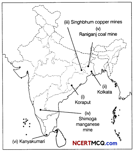
Question 10.
On the political map of India, locate and label the following features (Attempt any 5). (1 × 5 = 5)
(i) Koraput bauxite mines
(ii) Kolkata on the Golden Quadrilateral
(iii) Singhbhum copper mines
(iv) Shimoga manganese mine
(v) Raniganj coal mine
(vi) Important town of North-South corridor in Tamil Nadu
Answer: