Students can access the CBSE Sample Papers for Class 12 Geography with Solutions and marking scheme Term 2 Set 3 will help students in understanding the difficulty level of the exam.
CBSE Sample Papers for Class 12 Geography Term 2 Set 3 with Solutions
Time Allowed: 2 Hours
Maximum Marks: 35
Roll No. ___________
General Instructions:
- Question paper is divided into 5 sections A, B, C, D & E
- In section A, question number 1 to 3 are Very Short Answer type questions. Attempt any 3 questions.
- In section B, question number 4 is Source based question.
- In section C, question number 5 & 6 are Short Answer type questions.
- In section D, question number 7 to 9 are Long Answer type questions.
- In section E, question number 10 is a Map based question.
Section – A
Very Short Answer Questions
Question 1.
State about mineral based industries. (2)
Or
Highlight the characteristics of traditional large scale industrial regions.
Answer:
Mineral based industries use minerals as a raw material. Some industries use ferrous metallic minerals which contain ferrous (iron), such as iron and steel industries but some use non-ferrous metallic minerals, such as aluminium, copper and jewellery industries. Many industries use non-metallic minerals such as cement and pottery industries.
Or
Traditional large scale industrial regions are based on heavy industry. Their characteristics are
- High proportion of employment in manufacturing industry.
- High-density housing, often of inferior type, and poor services.
- Unattractive environment, for example, pollution, waste heaps, and so on.
- Problems of unemployment, emigration and derelict land areas caused by closure of factories because of a worldwide fall in demand.
![]()
Question 2.
Explain the concept of medical tourism by providing relevant examples to support your answer. (2)
Answer:
When medical treatment is combined with international tourism activity, it lends itself to what is commonly known as medical tourism. For example, India has emerged as the leading country of medical tourism in the world. World class hospitals located in metropolitan cities cater to patients all over the world. Medical tourism brings abundant benefits to developing countries like India, Thailand, Singapore and Malaysia. Beyond medical tourism, is the trend of outsourcing of medical tests and data interpretation.
Question 3.
Identify some popular tourist regions of the world. (2)
Answer:
Some popular tourist regions of the world are
- The warmer places around the Mediterranean Coast and the West Coast of India.
- Others include winter sports regions, found mainly in mountainous areas, and various scenic landscapes and national parks, which are scattered.
- Historic towns also attract tourists because of the monument, heritage sites and cultural activities.
Section – B
Source Based Question
Question 4.
Read the source given below and answer the following questions by choosing the correct option.
Ferrous minerals such as iron ore, manganese, chromite, etc., provide a strong base for the development of metallurgical industries. Our country is well-placed in respect of ferrous minerals both in reserves and production. India is endowed with fairly abundant resources of iron ore. It has the largest reserve of iron ore in Asia. The two main types of ore found in our country are haematite and magnetite.
It has great demand in international market due to its superior quality. The iron ore mines occur in close proximity to the coal fields in the North-Eastern Plateau region of the country which adds to their advantage. About 95 per cent of total reserves of iron ore is located in the States of Odisha, Jharkhand, Chhattisgarh, Karnataka, Goa, Telangana, Andhra Pradesh and Tamil Nadu. In Odisha, iron ore occurs in a series of hill ranges in Sundergarh, Mayurbhanj and Jhar.
The important mines are Gurumahisani, Sulaipet, Badampahar (Mayurbhaj), Kiruburu (Kendujhar) and Bonai (Sundergarh). Similar hill ranges, Jharkhand has some of the oldest iron ore mines and most of the iron and steel plants are located around them. Most of the important mines such as Noamundi and Gua are located in Poorbi and Pashchimi Singhbhum districts. This belt further extends to Durg, Dantewara and Bailadila.
Dalli, and Rajhara in Durg are the important mines of iron ore in the country. In Karnataka, iron ore deposits occur in Sandur -Hospet area of Ballari district, Baba Budan hills and Kudremukh in Chikkamagaluru district and parts of Shivamogga, Chitradurg and Tumakuru districts. The districts of Chandrapur, Bhandara and Ratnagiri in Maharashtra, Karimnagar and Warangal district of Telangana, Kurnool, Cuddapah and Anantapur districts of Andhra Pradesh, Salem and Nilgiris districts of Tamil Nadu are other iron mining regions. Goa has also emerged as an important producer of iron ore.
i. Which country has the largest reserves of Haematite and Magnetite in Asia? (1)
Answer:
India has the largest reserves of Haematite and Magnetite.
ii. Which states collectively has the highest iron ore reserves in India? (1)
Answer:
Odisha, Jharkhand, Chhattisgarh, Karnataka, Goa, Telangana, Andhra Pradesh and Tamil Nadu collectively has the highest iron ore reserves in India.
iii. Gurumahisani, Sulaipet, Badampahar (Mayurbhaj), Kiruburu (Kendujhar) and Bonai (Sundergarh) are iron ore mines located in which state of India? (1)
Answer:
Gurumahisani, Sulaipet, Badampahar (Mayurbhaj) (Kendujhar) and Bonai (Sundergarh) are iron ore mines located in Odisha.
![]()
Section – C
Short Answer Questions
Question 5.
Comment on the emergence of the notion of sustainable development in the world. (3)
Or
Discuss the process of development of the tribal area of Bharmaur region of Himachal Pradesh
Answer:
The notion of sustainable development emerged in the wake of general rise in the awareness of environmental issues in the late 1960s in Western World. It reflected the concern of people about undesirable effects of industrial development on the environment. The publication of ‘The Population Bomb’ by Ehrlich in 1968 and “The Limits to Growth’ by Meadows and others in 1972 further raised the level of fear among environmentalists in particular and people in general.
This sets the scenario for the emergence of new models of development under a broad phrase ‘sustainable development. Concerned with the growing opinion of world community on the environmental issues, the United Nations established a World Commission on Environment and Development (WCED) headed by the Norwegian Prime Minister Gro Harlem Brundtland.
The Commission gave its report (also known as Brundtland Report) entitled ‘Our Common Future’ in 1987. The report defines sustainable development as a “development that meets the needs of the present without compromising the ability of future generations to meet their own needs.”
The process of development of tribal area of Bharmaur of Himachal Pradesh, inhabited by the Gaddi tribe started in 1970s when Gaddis were included among’scheduled tribes’. Under the Fifth Five Year Plan, the tribal sub-plan was introduced in 1974 and Bharmaur was designated as one of the five Integrated Tribal Development Projects (ITDP) in Himachal Pradesh.
This area development plan was aimed at improving the quality of life of the Gaddis and narrowing the gap in the level of development between Bharmaur and other areas of Himachal Pradesh. This plan laid the highest priority on development of transport and communications, agriculture and allied activities, and social and community services.
The most significant contribution of tribal sub-plan in Bharmaur region is the development of infrastructure in terms of schools, healthcare facilities, potable water, roads, communications and electricity. But the villages located along the river Ravi in Holi and Khani areas are the main beneficiaries of infrastructural development. The remote villages in Tundah and Kugti areas still do not have sufficient infrastructure.
![]()
Question 6.
Explain how the Indian railways is the largest government undertaking in the country and highlight any of its achievement. (3)
Answer:
Indian Railways is the largest government undertaking in the country as it is one of the longest network in the world. It facilitates the movement of both freight and passengers and contributes to the growth of the economy. Its large size puts a lot of pressure on a centralised railway management system. Thus, in India, the railway system has been divided into 16 zones.
One of the important achievements of the Indian Railways has been the construction of Konkan Railway in 1998. It is 760-km long rail route connecting Roha in Maharashtra to Mangalore in Karnataka. It is considered an engineering marvel. It crosses 146 rivers, streams, nearly 2000 bridges and 91 tunnels. Asia’s largest tunnel which is nearly 6.5 km long, also lies on this route. The states of Maharashtra, Goa and Karnataka are partners in this undertaking.
Section – D
Long Answer Questions
Question 7.
Explain tertiary activities with relevant examples. (5)
Or
Communication is an integral part of exchanging information. Explain.
Answer:
Tertiary activities in an economy are related to the service sector where the service provider has theoretical knowledge and practical training. For example, in need of a medical assistance, an individual can visit a professional such as doctors.
In educational institutions, trained teachers impart education to the students. These services are provided against a payment. Manpower is an important component of the service sector as most of the tertiary activities are performed by skilled labour, professionally trained experts and consultants. In the initial stages of economic development, larger proportion of people works in the primary sector.
However, in a developed economy, the majority of workers get employment in tertiary activity and a moderate proportion is employed in the secondary sector. Tertiary activities include both production and exchange. The production involves the ‘provision’ of services that are ‘consumed’. The output is indirectly measured in terms of wages and salaries. Tertiary activities involve the commercial output of services rather than the production of tangible goods.
They are not directly involved in the processing of physical raw materials. Common examples are the work of a plumber, electrician, technician, launderer, barber, shopkeeper, driver, cashier, teacher, doctor, lawyer and publisher etc.
Or
Communication services involve the transmission of words and messages, facts and ideas. It is an integral part of exchanging information in the following ways
→ Telecommunications is a form of communication services. It has revolutionised communications because of the speed with which messages are sent. The time reduced is from weeks to minutes. Besides, the recent advancements like mobile telephony have made communications direct and instantaneous at any time and from anywhere.
→ Radio and television also help to relay news, pictures, and telephone calls to vast audiences around the world and hence they are termed as mass media. They are vital for advertising and entertainment.
→ Newspapers are able to cover events in all comers of the world. Satellite communication relays information of the earth and from space.
→ The internet has truly revolutionised the global communication system.
![]()
Question 8.
What are highways and border roads? Provide relevant examples of highways from India and other countries. (5)
Answer:
Highways are metalled roads connecting distant places. They are constructed in a manner for unobstructed vehicular movement. Highways are usually 80 m wide, with separate traffic lanes, bridges, flyovers and dual carriageways to facilitate uninterrupted traffic flow. In developed countries, every city and port town is linked through highways.
Border roads are the roads laid along international boundaries. They play an important role in integrating people in remote areas with major cities and providing defence. Almost all countries have such roads to transport goods to border villages and military camps. Examples of highways from India and other countries are
→ In India, there are many highways linking the major towns and cities. For example, National Highway No. 7 (NH 7), connecting Varanasi with Kanya Kumari, is the longest in the country.
→ The Trans Canadian Highway links Vancouver in British Columbia (west coast) to St. John’s City in Newfoundland (east coast) and the Alaskan Highway links Edmonton (Canada) to Anchorage (Alaska).
→ The Trans Continental Stuart Highway connects Darwin (north coast) and Melbourne via Tennant Creek and Alice Springs in Australia.
Question 9.
State two important man-made canals which are important for global commerce. (5)
Answer:
The Suez and the Panama Canals are two vital man-made navigation canals or waterways which serve as gateways of commerce for both the eastern and western worlds. The Suez Canal This canal had been constructed in 1869 in Egypt between Port Said in the North and Port Suez in the South linking the Mediterranean Sea and the Red Sea.
It gives Europe a new gateway to the Indian Ocean and reduces direct sea-route distance between Liverpool and Colombo compared to the Cape of Good Hope route. It is a sea-level canal without locks which is about 160 km and 11 to 15 m deep. A railway follows the canal to Suez, and from Ismailia there is a branch line to Cairo.
A navigable fresh-water canal from the Nile also joins the Suez Canal in Ismailia to supply fresh-water to Port Said and Suez. The Panama Canal This canal connects the Atlantic Ocean in the east to the Pacific Ocean in the west. It has been constructed across the Panama Isthmus between Panama City and Colon by the US government which purchased 8 km of area on either side and named it the Canal Zone. The Canal is about 72 km long and involves a very deep cutting for a length of 12 km.
It has a six lock system and ships cross the different levels (26 m up and down) through these locks before entering the Gulf of Panama. It shortens the distance between New York and San Francisco by 13,000 km by sea.
![]()
Section – E
Map Based Question
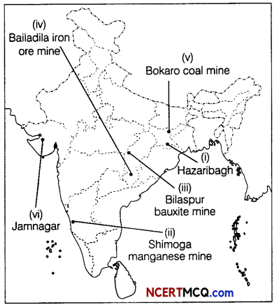
Question 10.
(a) On a political map of India, mark and indicate the following features (Attempt any 5) (1 × 5 = 5)
(i) Hazaribagh copper mine
(ii) Manganese mine in Karnataka
(iii) Bilaspur bauxite mine
(iv) Bailadila iron-ore mine
(v) Bokaro coal mine
(vi) Jamnagar oil refineries
Answer: