Students can access the CBSE Sample Papers for Class 12 Geography with Solutions and marking scheme Term 2 Set 4 will help students in understanding the difficulty level of the exam.
CBSE Sample Papers for Class 12 Geography Term 2 Set 4 with Solutions
Time Allowed: 2 Hours
Maximum Marks: 35
Roll No. ___________
General Instructions:
- Question paper is divided into 5 sections A, B, C, D & E
- In section A, question number 1 to 3 are Very Short Answer type questions. Attempt any 3 questions.
- In section B, question number 4 is Source based question.
- In section C, question number 5 & 6 are Short Answer type questions.
- In section D, question number 7 to 9 are Long Answer type questions.
- In section E, question number 10 is a Map based question.
Section – A
Very Short Answer Questions
Question 1.
Differentiate between the characteristics of large scale manufacturing and small scale manufacturing (2)
Or
Differentiate between private sector industries and joint sector industries.
Answer:
The large scale manufacturing is characterised by a number of supporting factors like a large market, various raw materials, enormous use of energy, specialised workers, advanced technology, assembly line mass production and large capital investments. On the other hand, the characteristics of small scale manufacturing are use of local raw material, simple power driven machines and semi-skilled labour.
Or
Private sector industries are owned by individual investors. These are managed by private organisations. On the other hand, Joint sector industries are managed by joint stock companies or sometimes the private and public sectors together establish and manage the industries.
![]()
Question 2.
How has the Border Road Organisation (BRO) contributed to road transport in India? (2)
Answer:
Border Road Organisation (BRO) has contributed to road transport in India in many ways, some of which are . It has constructed roads in high altitude mountainous terrain joining Chandigarh with Manali (Himachal Pradesh) and Leh (Ladakh). This road runs at an average altitude of 4,270 metres above the mean sea level. Apart from the construction and maintenance of roads in strategically sensitive areas, the BRO also undertakes snow clearance in high altitude areas.
Question 3.
State in brief the types of pollutants involved in water pollution. Also mention sources of pollution for this. (2)
Answer:
In water pollution, the types of pollutants involved are dissolved and suspended solids, ammonia and urea, nitrate and nitrites, chloride, fluoride, carbonates, oil and grease, insecticide and pesticide residue, tannin, coliform MPM (bacterial count) sulphates and sulphides, heavy metals like lead, arsenic, mercury and manganese, radioactive substances, etc. Some of the major sources of water pollution are sewage disposal, urban run-off, toxic effluents from industries, run-off over cultivated lands and nuclear power plants.
Section – B
Source Based Question
Question 4.
Read the source given below and answer the following questions by choosing the correct option.
Railways are a mode of land transport for bulky goods and passengers over long distances. The railway gauges vary in different countries and are roughly classified as broad (more than 1.5 m), standard (1.44 m), metre gauge (1 m) and smaller gauges.
The standard gauge is used in the UK Commuter trains are very popular in UK, USA, Japan and India. These carry millions of passengers daily to and from in the city. There are about 13 lakh km of railways open for traffic in the world. Europe has one of the most dense rail networks in the world. There are about 4,40,000 km of railways, most of which is double or multiple-tracked.
Belgium has the highest density of 1 km of railway for every 6.5 sq. kms area. The industrial regions exhibit some of the highest densities in the world. The important rail heads are London, Paris, Brussels, Milan, Berlin and Warsaw. Passenger transport is more important than freight in many of these countries. Underground railways are important in London and Paris. Channel Tunnel, operated by Euro Tunnel Group through England, connects London with Paris.
Trans-continental railway lines have now lost their importance to quicker and more flexible transport systems of airways and roadways. In Russia, railways account for about 90 per cent of the country’s total transport with a very dense network west of the Urals. Moscow is the most important rail head with major lines radiating to different parts of the country’s vast geographical area.
Underground railways and commuter trains are also important in Moscow. North America has one of the most extensive rail networks accounting for nearly 40 per cent of the world’s total. In contrast to many European countries, the railways are used more for long-distance bulky freight like ores, grains, timber and machinery than for passengers. The most dense rail network is found in the highly industrialised and urbanised region of East Central USA and adjoining Canada.
i. The West-East Australian railway line runs across the country in which regions? (1)
Answer:
The West-East Australian railway line runs across the country from Perth to Sydney.
ii. Which continent has the largest network of railways in the world? (1)
Answer:
Asia has the largest network of railways in the world.
iii. What is the common form of public transport in London and Moscow? (1)
Answer:
A common form of public transport in London and Moscow is underground railways.
![]()
Section – C
Short Answer Questions
Question 5.
Differentiate between rural marketing centres and urban marketing centres. (3)
Answer:
Differences between rural marketing centres and urban marketing centres are
| Rural Marketing | Urban Marketing |
| Rural marketing centres cater to nearby settlements. These are quasi-urban centres They serve as trading centres of the most rudimentary type. | Urban marketing centres have more widely specialised urban services. They provide ordinary goods and services as well as many of the specialised goods and services required by people. |
| In these centres, personal and professional services are not well-developed. These form local collecting and distributing centres. Most of these have mandis (wholesale markets) and also retailing areas. | Urban centres, therefore, offer manufactured goods as well as many specialised markets develop, e.g., markets for labour, housing, semi or finished products. |
| They are not actually urban centres but are significant centres for making available goods and services which are most frequently demanded by rural folk. | Services of educational institutions and professionals such as teachers, lawyers, consultants, physicians, dentists and veterinary doctors are available. |
Question 6.
Outline the distribution of sources of bauxite in India and mention any one use of this mineral. Classify minerals on the basis of chemical and physical properties. (3)
Answer:
Bauxite is found mainly in tertiary deposits and is associated with laterite rocks occurring extensively either on the plateau or hill ranges of peninsular India and also in the coastal tracts of the country. The distribution of bauxite in India is
→ Odisha happens to be the largest producer of Bauxite. Kalahandi and Sambalpur are the leading producers. The other two areas which have been increasing their production are Bolangir and Koraput.
→ The patlands of Lohardaga in Jharkhand have rich deposits of bauxite.
→ Gujarat, Chhattisgarh, Madhya Pradesh and Maharashtra are other major producers. Bhavanagar, and Jamnagar in Gujarat have the major deposits. Chhattisgarh has bauxite deposits in Amarkantak Plateau while Katni Jabalpur area and Balaghat in M.P. have important deposits of bauxite. Kolaba, Thane, Ratnagiri, Satara, Pune and Kolhapur in Maharashtra are important producers.
→ Tamil Nadu, Karnataka and Goa are minor producers of bauxite. Bauxite is the ore, which is used in manufacturing of aluminium.
Or
On the basis of chemical and physical properties, minerals may be grouped under two main categories of metallics and non-metallics. Metallic minerals are the sources of metals. Iron ore, copper, gold produce metal and are included in this category. Metallic minerals are further divided into ferrous and non-ferrous metallic minerals. Ferrous, as you know, refers to iron.
All those minerals which have iron content are ferrous such as iron ore itself and those which do not have iron content are non-ferrous such as copper, bauxite, etc. Non-metallic minerals are either organic in origin such as fossil fuels also known as mineral fuels which are derived from the buried animal and plant life such as coal and petroleum. Other type of non-metallic minerals are inorganic in origin such as mica, limestone and graphite, etc.
![]()
Section – D
Long Answer Questions
Question 7.
What are the characteristics of modern large scale manufacturing? (5)
Or
What are traditional large scale industrial regions? Discuss the example of Ruhr coal field located in Germany.
Answer:
Modern large scale manufacturing has the following characteristics
→ Specialisation of Skills/Methods of Production Under the ‘craft’ method factories produce only a few pieces which are made-to-order. So, the costs are high. On the other hand, mass production involves production of large quantities of standardised parts by each worker performing only one task repeatedly and thereby reducing the overall cost.
→ Mechanisation It refers to using gadgets which accomplish tasks. Automation (without aid of human thinking during the manufacturing process) is the advanced stage of mechanisation. Automatic factories with feedback and closed loop computer control systems where machines are developed to think’, have sprung up all over the world. It reduces error due to human negligence, increase output due to use of machines and can work at any time due to automated instructions and minimal supervision. Overall, mechanisation of manufacturing process reduces error and increase output in a given period of time.
→ Technological Innovation Innovations through research and development strategy are an important aspect of modern manufacturing for quality control, eliminating waste and inefficiency, and combating pollution. With technological advancements, the machines and automated processes are regularly being upgraded, to reduce human interventions.
Or
Traditional Large-Scale Industrial Regions are based on heavy industry, often located near coal-fields and engaged in metal smelting, heavy engineering, chemical manufacture or textile production. These industries are now known as smokestack industries.
Traditional industrial regions can be recognised by –
- High proportion of employment in manufacturing industry. High-density housing, often of inferior type, and poor services. Unattractive environment, for example, pollution, waste heaps, and so on.
- Problems of unemployment, emigration and derelict land areas caused by closure of factories because of a worldwide fall in demand.
The Ruhr coal field is located in the East of Germany and represents one of the largest coal reserves in the country. This coal field is estimated to have over 42 billion tonnes of coal reserves. This has been one of the major industrial regions of Europe for a long time. Coal, iron and steel formed on the basis of the economy, but as the demand for coal declined, the industry started shrinking.
Even after the iron ore was exhausted, the industry remained, using imported ore brought by waterways to the Ruhr. The Ruhr region is responsible for 80 per cent of Germany’s total steel production Changes in the industrial structure have led to the decay of some areas, and there are problems of industrial waste and pollution.
The future prosperity of the Ruhr is based less on the products of coal and steel, for which it was initially famous, and more on the new industries like the huge Opel car assembly plant, new chemical plants, universities.
![]()
Question 8.
Discuss the distribution of minerals in India. (5)
Answer:
Most of the metallic minerals in India occur in the peninsular plateau region in the old crystalline rocks. Over 97 per cent of coal reserves occur in the valleys of Damodar, Sone, Mahanadi and Godavari. Petroleum reserves are located in the sedimentary basis of Assam, Gujarat and Mumbai High ie., off-shore region in the Arabian Sea. New reserves have been located in the Krishna-Godavari and Kaveri basins. Most of the major mineral resources occur to the east of a line linking Mangaluru and Kanpur. Minerals are generally concentrated in three broad belts in India. These belts are
- The North-Eastern Plateau Region This belt covers Chhotanagpur (harkhand), Odisha Plateau, West Bengal and parts of Chhattisgarh
- The South-Western Plateau Region This belt extends over Kamataka, Goa and contiguous Tamil Nadu uplands and Kerala. This belt is rich in ferrous metals and bauxite. It also contains high grade iron ore, manganese and limestone.
- The North-Western Region This belt extends along Aravali in Rajasthan and part of Gujarat. Rajasthan is rich in building stones i.e. sandstone, granite, marble. Gypsum and Fuller’s earth deposits are also extensive.
![]()
Question 9.
Petroleum is an essential fuel for several industries in an economy. State its uses in an economy and production in India. (5)
Answer:
Petroleum is a conventional fossil fuel. Its uses are .
- It is an essential source of energy for all internal combustion engines in automobiles, railways and aircraft.
- Its numerous by-products are processed in petrochemical industries, such as fertiliser, synthetic rubber, synthetic fibre, medicines, vaseline, lubricants, wax, soap and cosmetics.
The production of crude petroleum is
- Digboi in Assam was the only oil producing region till 1956 but the scenario changed after 1956.
- In Assam, Digboi, Naharkatiya and Moran are important oil producing areas.
- The major oilfields of Gujarat are Ankaleshwar, Kalol, Mehsana, Nawagam, Kosamba and Lunej.
- Mumbai High which lies 160 km off Mumbai was discovered in 1973 and production commenced in 1976.
- Oil and natural gas have been found in exploratory wells in Krishna Godavari and Kaveri basin on the East coast.
Section – E
Map Based Question
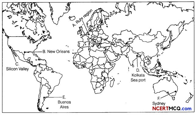
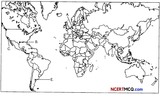
Question 10.
On the political map of the world, identify the following features (Attempt any 5) (1 × 5 = 5)
A. A region of secondary activities
B. A major seaport
C. A secondary activity region in South-West USA
D. A major seaport
E. An important airport
F. The Terminal Station of Trans-Continental Railway
Answer: