Students can access the CBSE Sample Papers for Class 12 Geography with Solutions and marking scheme Term 2 Set 5 will help students in understanding the difficulty level of the exam.
CBSE Sample Papers for Class 12 Geography Term 2 Set 5 with Solutions
Time Allowed: 2 Hours
Maximum Marks: 35
Roll No. ___________
General Instructions:
- Question paper is divided into 5 sections A, B, C, D & E
- In section A, question number 1 to 3 are Very Short Answer type questions. Attempt any 3 questions.
- In section B, question number 4 is Source based question.
- In section C, question number 5 & 6 are Short Answer type questions.
- In section D, question number 7 to 9 are Long Answer type questions.
- In section E, question number 10 is a Map based question.
Section – A
Very Short Answer Questions
Question 1.
Identify and explain any two factors affecting tourism. (2)
Or
Comment on the role of communication in today’s world.
Answer:
Two factors that affect tourism are
- Demand Since the last century, the demand for holidays has increased rapidly. Improvements in the standard of living and increased leisure time, permit many more people to go on holidays for leisure.
- Transport The opening-up of tourist areas has been aided by improvement in transport facilities. Travel is easier by car, with better road systems. More significant in recent years has been the expansion in air transport.
Or
The role of communication in today’s world is
- Telecommunication has revolutionised communications because of the speed with which messages are sent. The time reduced is from weeks to minutes.
- Radio and television through satellite communication also help to relay news, pictures, and telephone calls to vast audiences around the world and hence they are termed as mass media.
- They are vital for advertising and entertainment.
![]()
Question 2.
State about state highways and district roads. (2)
Answer:
State Highways are constructed and maintained by state governments. They join the state . capitals with district headquarters and other important towns. These roads are connected to the National Highways. These constitute 4 per cent of total road length in the country. District Roads are the connecting link between District Headquarters and the other important nodes in the district. They account for 14 per cent of the total road length of the country.
Question 3.
Which are the most polluted stretches of the Ganga river and what are the sources contributing to the pollution?
Answer:
The most polluted stretches of the Ganga river are downstream of Kanpur, downstream of Varanasi and Farkka Barrage. The sources of pollution in the Ganga River are industrial pollution from towns like Kanpur, domestic wastes from urban centres and dumping of carcasses in the river. Cities of Kanpur, Allahabad, Varanasi, Patna and Kolkata release domestic waste into the river flowing through Uttar Pradesh, Bihar and West Bengal in India.
Section – B
Source Based Question
Question 4.
Read the source given below and answer the following questions by choosing the correct option.
Bauxite is the ore, which is used in manufacturing of aluminium. Bauxite is found mainly in tertiary deposits and is associated with laterite rocks occurring extensively either on the plateau or hill ranges of peninsular India and also in the coastal tracts of the country.
Odisha happens to be the largest producer of Bauxite. Kalahandi and Sambalpur are the leading producers. The other two areas which have been increasing their production are Bolangir and Koraput. The patlands of Lohardaga in Jharkhand have rich deposits. Gujarat, Chhattisgarh, Madhya Pradesh and Maharashtra are other major producers.
Bhavanagar, and Jamnagar in Gujarat have the major deposits. Chhattisgarh has bauxite deposits in Amarkantak Plateau while Katni Jabalpur area and Balaghat in M.P. have important deposits of bauxite. Kolaba, Thane, Ratnagiri, Satara, Pune and Kolhapur in Maharashtra are important producers. Tamil Nadu, Kamataka and Goa are minor producers of bauxite. Copper is an indispensable metal in the electrical industry for making wires, electric motors, transformers and generators.
It is alloyable, malleable and ductile. It is also mixed with gold to provide strength to jewellery. The Copper deposits mainly occur in Singhbhum district in Jharkhand, Balaghat district in Madhya Pradesh and Jhunjhunu and Alwar districts in Rajasthan. Minor producers of Copper are Agnigundala in Guntur District (Andhra Pradesh), Chitradurg and Hasan districts (Karnataka) and South Arcot district (Tamil Nadu).
i. State important features of copper. (1)
Answer:
Important features of copper are Copper is alloyable and melleable i.e. can be converted into thin sheets. . It is ductile i.e. can be drawn into thin wires.
ii. In which locations, bauxite is found? (1)
Answer:
Bauxite is found both on high elevations and near the shore. For example, Odisha, Jharkhand, Gujarat, Chhattisgarh and so on.
iii. The Balaghat district in Madhya Pradesh, and Jhunjhunu and Alwar districts in Rajasthan in India have deposits of which metal? (1)
Answer:
The Balaghat district in Madhya Pradesh, and Jhunjhunu and Alwar districts in Rahasthan in India have deposits of copper metal.
![]()
Section – C
Short Answer Questions
Question 5.
Outline the distribution of iron and steel industry across the world. Or Identify the three subsectors of the cotton textile industry. Outline the distribution of cotton textile industry in the world. (3)
Answer:
The iron and steel industry is one of the most complex and capital-intensive industries and is concentrated in the advanced countries of North America, Europe and Asia. The distrubution of iron and steel industry across the world is
In USA, most of the production comes from the north Appalachian region (Pittsburgh), Great Lake region (Chicago-Gary, Erie, Cleveland, Lorain, Buffalo and Duluth) and the Atlantic Coast (Sparrows Point and Morisville). The industry has also moved towards the southern state of Alabama. Pittsburg area is now losing ground. It has now become the “rust bowl” of U.S.A.
In Europe, UK, Germany, France, Belgium, Luxembourgh, the Netherlands and Russia are the leading producers. The important steel centres are Scun Thorpe, Port Talbot, Birmingham and Sheffield in the U.K; Duisburg, Dortmund, Dusseldorf and Essen in Germany; Le Creusot and St. Ettienne in France; and Moscow, St. Petersburgh, Lipetsk, Tula, in Russia and Krivoi Rog, and Donetsk in Ukraine.
In Asia, the important centres include Nagasaki and Tokyo-Yokohama in Japan; Shanghai, Tienstin and Wuhan in China; and Jamshedpur, Kulti-Burnpur, Durgapur, Rourkela, Bhilai, Bokaro, Salem, Visakhapatnam and Bhadravati in India.
Or
Cotton textile industry has three sub-sectors i.e., handloom, powerloom and mill sectors
- Handloom sector is labour-intensive and provides employment to semi-skilled workers. It requires small capital investment. This sector involves spinning, weaving and finishing of the fabrics.
- The powerloom sector introduces machines and becomes less labour intensive and the volume of production increases.
- Cotton textile mill sector is highly capital intensive and produces fine clothes in bulk Cotton textile manufacturing requires good quality cotton as raw material.
- India, China, USA, Pakistan, Uzbekistan, Egypt produces more than half of the world’s raw cotton.
- The UK, NW European countries and Japan also produce cotton textile made from imported yarn Europe alone accounts for nearly half of the world’s cotton imports.
![]()
Question 6.
Briefly outline the geographical location of the Bharmaur region of Himachal Pradesh. (3)
Answer:
Bharmaur is a tehsil in Chamba district of Himachal Pradesh. It is a notified tribal area since 21st November, 1975. The geographical location and features of the Bharmaur region are
- This region lies between 32° 11′ N and 32°41′ N latitudes and 76° 22′ E and 76° 53’E longitudes.
- It is spread over an area of about 1,818 sq km, the region mostly lies between 1,500 m to 3,700 m above the mean sea level.
- This region popularly known as the homeland of Gaddis is surrounded by lofty mountains on all sides. It has Pir Panjal in the north and Dhaula Dhar in the south.
- In the east, the extension of Dhaula Dhar converges with Pir Panjal near Rohtang Pass.
- The river Ravi and its tributaries, the Budhil and the Tundahen, drain this territory, and carve out deep gorges. These rivers divide the region into four physiographic divisions called Holi, Khani, Kugti and Tundah areas.
- Bharmaur experiences freezing weather conditions and snowfall in winter. Its mean monthly temperature in January remains 4°C and in July 26°C.
Section – D
Long Answer Questions
Question 7.
Industries are classified based on their sizes depending on the investme and output. Explain the basis of size based classification in industries. (5)
Or
Raw material is critical for functioning of an industry. How are industries classified based on raw materials?
Answer:
The size of an industry is determined by the capital invested, number of workers employed and volume of production determine the size of industry. Accordingly, industries may be classified into household or cottage, small-scale and large-scale on the basis of size
Household or Cottage Industries It is the smallest manufacturing unit. The artisans use local raw materials and simple tools to produce everyday goods in their homes with the help of their family members or part-time labour. Finished products may be for consumption in the same household or, for sale in local (village) markets, or, for barter.
Some common everyday products produced in this sector of manufacturing include foodstuffs, fabrics, mats, containers, tools, furniture, shoes, and figurines from wood lot and forest, shoes, thongs and other articles from leather, pottery and bricks from clays and stones.
Small Scale Manufacturing It is distinguished from household industries by its production techniques and place of manufacture (a workshop outside the home/cottage of the producer). This type of manufacturing uses local raw material, simple power-driven machines and semi-skilled labour. It provides employment and raises local purchasing power. Therefore, countries like India, China, Indonesia and Brazil, etc. have developed labour-intensive small scale manufacturing in order to provide employment to their population.
Large Scale Manufacturing It involves a large market, various raw materials, enormous energy, specialised workers, advanced technology, assembly-line mass production and large capital. This kind of manufacturing developed in the last 200 years, in the United Kingdom, NorthEastern USA and Europe. Now it has diffused to almost all over the world. The industries can be classified on the basis of raw material as
Agro Based Industries Agro processing involves the processing of raw materials from the field and the farm into finished products for rural and urban markets. Major Agro-processing industries are food processing, sugar, pickles, fruits juices, beverages (tea, coffee and cocoa), spices and oils fats and textiles (cotton, jute, silk), rubber, etc.
Mineral Based Industries These industries use minerals as a raw material. Some industries use ferrous metallic minerals which contain ferrous (iron), such as iron and steel industries but some use non-ferrous metallic minerals, such as aluminium, copper and jewellery industries. Many industries use non-metallic minerals such as cement and pottery industries.
Chemical Based Industries Such industries use natural chemical minerals, e.g. mineral-oil (petroleum) is used in petrochemical industry. Salts, sulphur and potash industries also use natural minerals. Synthetic fibre, plastic, etc. are other examples of chemical based industries.
Forest Based Industries Forests provide many major and minor products which are used as raw material. Timber for furniture industry, wood, bamboo and grass for paper industry, lac for lac industries come from forests.
Animal Based Industries Leather for leather industry and wool for woollen textiles are obtained from animals. Besides, ivory is also obtained from elephant’s tusks.
![]()
Question 8.
Explain the concept of Trans-continental Railways with any two relevant and well known examples from world. (5)
Answer:
Trans-continental railways run across the continent and link its two ends. They were constructed for economic and political reasons to facilitate long runs in different directions. Since, trans-continental railways run across a continent, they cover large land mass and connects interior parts of the continent to major industrial and transportation hubs on the continent borders and ocean shores. These railways forms the backbone of many countries as they move a large amount of freight and passenger across large distances. Two of the well-known trans-continental railways in world are
(i) Trans-Siberian Railway This is a major rail route of Russia which runs from St. Petersburg in the west to Vladivostok on the Pacific Coast in the east passing through Moscow, Ufa, Novosibirsk, Irkutsk, Chita and Khabarovsk. It is the most important route in Asia and the longest (9,332 km) tracked and electrified trans-continental railway in the world.
It has helped in opening up its Asian region to West European markets. It runs across the Ural Mountains Ob and Yenisei rivers. There are connecting links to the south, namely, to Odessa (Ukraine), Baku on the Caspian Coast, Tashkent (Uzbekistan), Ulan Bator (Mongolia), and Shenyang (Mukden) and Beijing in China.
(ii) Trans-Canadian Railways This 7,050 km long rail-line in Canada runs from Halifax in the east to Vancouver on the Pacific Coast passing through Montreal, Ottawa, Winnipeg and Calgary. It was constructed in 1886, initially as part of an agreement to make British Columbia on the west coast join the Federation of States.
Later on, it gained economic significance because it connected the Quebec-Montreal Industrial Region with the wheat belt of the Prairie Region and the Coniferous Forest region in the north. Thus, each of these regions became complementary to the other. A loop line from Winnipeg to Thunder Bay (Lake Superior) connects this rail-line with one of the important waterways of the world. This line is the economic artery of Canada. Wheat and meat are the important exports on this route.
![]()
Question 9.
Waterways have been used for transport of people and cargo since medieval times. Elucidate the advantages and types of waterways transport with examples. (5)
Answer:
Water transport is an essential form of transport. It is associated with waterbodies such as lakes, rivers, seas and oceans. The advantages of waterways are
Transport through waterways doesn’t require construction of a new route as an already existing water body is used for the transport. Movement through water offers less friction compared to roads and hence is more energy efficient.
Compared to land and air, ocean transport is a cheaper means of haulage (carrying of load) of bulky material over long distances from one continent to another. Water transport is broadly divided into sea routes and inland waterways
Sea routes The oceans offer a smooth highway traversable in all directions with minimal maintenance costs. Some of the important sea routes are the Northern Atlantic sea route linking USA to Europe and the Mediterranean-Indian ocean route linking regions along the South China Sea, Strait of Malacca, Indian Ocean, Red Sea, Suez Canal and Mediterranean.
Inland Waterways Rivers, canals, lakes and coastal areas are important inland waterways. The development of inland waterways is dependent on the navigability width and depth of the channel, continuity in the water flow, and transport technology in use. Important waterways are the Rhine Waterways through Germany and the Netherlands. It is navigable for 700 km; and Volga Waterway in Russia with a navigable waterway of 11,200 km.
![]()
Section – E
Map Based Question
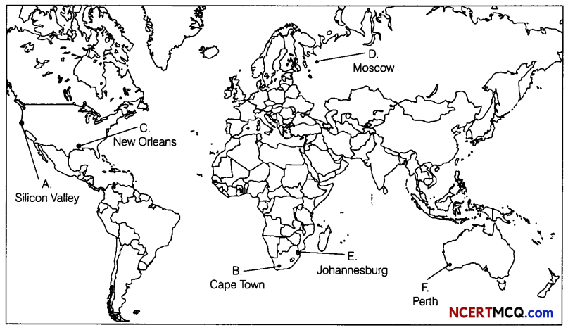
Question 10.
On the political map of the world, identify the places (Attempt any 5). (1 × 5 = 5)
A. A place of secondary activities
B. A major sea port
C. A major sea port
D. An international airport
E. A major airport
F. The Terminal Station of Trans-Continental Railway
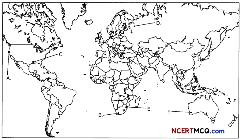
Answer: