Students can access the CBSE Sample Papers for Class 12 Geography with Solutions and marking scheme Term 2 Set 8 will help students in understanding the difficulty level of the exam.
CBSE Sample Papers for Class 12 Geography Term 2 Set 8 with Solutions
Time Allowed: 2 Hours
Maximum Marks: 35
Roll No. ___________
General Instructions:
- Question paper is divided into 5 sections A, B, C, D & E
- In section A, question number 1 to 3 are Very Short Answer type questions. Attempt any 3 questions.
- In section B, question number 4 is Source based question.
- In section C, question number 5 & 6 are Short Answer type questions.
- In section D, question number 7 to 9 are Long Answer type questions.
- In section E, question number 10 is a Map based question.
Section – A
Very Short Answer Questions
Question 1.
Describe the highways of any one developed region of the world. (2)
Answer:
In developed countries, every city and port town is linked through highways. For example, in North America, highway density is high, about 0.65 km per sq km. Every place is within 20 km distance from a highway. Cities located on the Pacific coast (west) are well-connected with those of the Atlantic Coast (East). Likewise, the cities of Canada in the north are linked with those of Mexico in the South.
![]()
Question 2.
Define transport (2)
Or
Explain the dependence of transportation on distance and volume of passenger or cargo by giving examples.
Answer:
Transport is a service or facility for the carriage of persons and goods from one place to the other using humans, animals and different kinds of vehicles. Such movements take place over land, water and air. Roads and railways form part of land transport; while shipping and waterways and airways are the other two modes. Transportation depends on distance and volume of passenger or cargo. For example,
- Road transport is cheaper and faster over short distances and for door-todoor services.
- Railways are most suited for large volumes of bulky materials over long distances within a country.
Question 3.
State the objective and activities of NITI Aayog. (2)
Answer:
NITI Aayog has been set up with the objective of involving the states in economic policy making for India for providing strategic and technical advice to the Central and State governments. Its entire activities can be categorised as
- Policy and programme framework.
- Cooperative federalism
- Monitoring and evaluation
- Think tank and knowledge hub
![]()
Section – B
Source Based Question
Question 4.
Read the source given below and answer the following questions by choosing the correct options.
The pressure on agricultural land increases not only due to the limited availability but also by deterioration of quality of agricultural land. Soil erosion, waterlogging, salinisation and alkalinisation of land lead to land degradation. What happens if land is consistently used without managing its fertility? Land is degraded and productivity declines.
Land degradation is generally understood either as a temporary or a permanent decline in productive capacity of the land. Though all degraded land may not be wasteland, but unchecked process of degradation may lead to the conversion to wasteland. There are two processes that induce land degradation. These are natural and created by human beings.
National Remote Sensing Centre (NRSC) has classified wastelands by using remote sensing techniques and it is possible to categorise these wastelands according to the processes that have created them. There are a few types of wastelands such as gullied /ravinous land, desertic or coastal sands, barren rocky areas, steep sloping land, and glacial areas, which are primarily caused by natural agents.
There are other types of degraded lands such as waterlogged and marshy areas, land affected by salinity and alkalinity and land with or without scrub, which have largely been caused by natural as well as human factors. There are some other types of wastelands such as degraded shifting cultivation area, degraded land under plantation crops, degraded forests, degraded pastures, and mining and industrial wastelands are caused by human action.
i. What is the result of unregulated use of agricultural land? (1)
Answer:
Unregulated use of agricultural can result in increase in soil moisture and fertility.
ii. Land degradation can be temporary or permanent. What is the possible reason behind a permanent land degradation? (1)
Answer:
The possible reason behind a permanent land degradation could be ignorance of sign of degradation and no efforts to restore the land.
iii. Lands under shifting cultivation or selective plantation may degrade due to which factor? (1)
Answer:
Lands under shifting cultivation or selective plantation may degrade due to loss of soil fertility and moisture.
Section – C
Short Answer Questions
Question 5.
Explain how access to transportation and communication facilities affect the location of industries especially in the context of footloose industries. (3)
Or
Identify the reason behind the resulting of a ‘New-Ruhr’ landscape. Explain this ‘New-Ruhr’ landscape.
Answer:
Access to transportation and communication facilities greatly affect the location of industries. Modem industry is inseparably tied to transportation systems. Improvements in transportation led to integrated economic development and regional specialisation of manufacturing. The cost of transport and location of industries depends on speedy and efficient transport facilities to carry raw materials to the factory and to move finished goods to the market.
In this context, footloose industries can be located in a wide variety of places. The important factor in their location is accessibility by road network. They are not dependent on any specific raw material, weight losing or otherwise. They largely depend on component parts which can be obtained anywhere. They produce in small quantity and also employ a small labour force. These are generally not polluting industries.
Or
‘New-Ruhr’ landscape refers to the change in industrial and other economic activities in the Ruhr coal field region in Germany. The reason behind it is changing demands and structure in coal and steel industries. The Ruhr coal field in Germany has been one of the major industrial regions of Europe. Coal and iron and steel formed the basis of the economy, but as the demand for coal declined, the industry started shrinking.
Once the iron ore exhausted, the industry confirmed on imported ore. The Ruhr region is responsible for 80 per cent of Germany’s total steel production. However, changes in the industrial structure have led to the decay of some areas, and problems of industrial waste and pollution. The future prosperity of the Ruhr is based less on the products of coal and steel and more on the new industries like the huge Opel car assembly plant, new chemical plants, universities. Outof-town shopping centres have appeared resulting in a ‘New Ruhr’ landscape.
![]()
Question 6.
Differentiate between the distribution of mineral resources in the North Eastern Plateau region and South Western Plateau region of India. (3)
Answer:
Differences between the distribution of mineral resources in North Eastern Plateau region and South Western Plateau region are North Eastern Plateau Region This belt covers Chota Nagpur (Jharkhand), Odisha Plateau, West Bengal and parts of Chhattisgarh Major iron and steel industries are located in this region It has variety of minerals viz. iron ore coal, manganese, bauxite, mica.
The South-Western Plateau Region This belt extends over Karnataka, Goa and contiguous Tamil Nadu uplands and Kerala. This belt is rich in ferrous metals and bauxite. It also contains high grade iron ore, manganese and limestone. This belt packs in coal deposits except Neyveli lignite. This belt does not have as diversified mineral deposits as the North-Eastern belt. Kerala has deposits of monazite and thorium, bauxite clay. Goa has iron ore deposits.
Section – D
Long Answer Questions
Question 7.
Iron and steel industry are basic industry which are important for development of an economy. State its global distribution with details on major iron and steel producing countries.(5)
Or
Technology has revolutionised the global economies with faster and efficient production in all types of industries. Discuss the concept of ‘High technology industries’.
Answer:
The iron and steel industry is one of the most complex and capital-intensive industries and is largely concentrated in the advanced countries of North America, Europe and Asia. In 1970’s, Japan, USA and western Europe were accounting for 2/3rd global production of iron and steel. However, the developing nations such as China, India, Brazil and South Korea gradually became important steel producers. The global distribution of iron and steel industry is
In USA, most of the production comes from the north Appalachian region (Pittsburgh), Great Lake region (Chicago-Gary, Erie, Cleveland, Lorain, Buffalo and Duluth) and the Atlantic Coast (Sparrows Point and Morisville). The industry has also moved towards the southern state of Alabama. In Europe, U.K, Germany, France, Belgium, Luxembourgh, the Netherlands and Russia are the leading producers.
The important steel centres are Scun Thorpe, Port Talbot, Birmingham and Sheffield in the U.K.; Duisburg, Dortmund, Dusseldorf and Essen in Germany, Le Creusot and St. Ettienne in France, and Moscow, St. Petersburgh, Lipetsk, Tula, in Russia and Krivoi Rog, and Donetsk in Ukraine.
In Asia, the important centres include Nagasaki and Tokyo-Yokohama in Japan; Shanghai, Tienstin and Wuhan in China; and Jamshedpur, Kulti-Burnpur, Durgapur, Rourkela, Bhilai, Bokaro, Salem, Visakhapatnam and Bhadravati in India.
Or
High-tech industries refer to those industries where the major work force has technology based occupations, such as engineers and scientists. High technology, or simply high-tech, is the latest generation of manufacturing activities. Some of the key features of high-tech industries are
In these industries, application of intensive Research and Development (R and D) efforts leads to the manufacturing of products of an advanced scientific and engineering character. Professional (white collar) workers make up a large share of the total workforce. These highly skilled specialists greatly outnumber the actual production (blue collar) workers.
Robotics on the assembly line, Computer – aided Design (CAD) and manufacturing, electronic controls of smelting and refining processes, and the constant development of new chemical and pharmaceutical products are notable examples of a high-tech industry.
Neatly spaced, low, modern, dispersed, office-plant-lab buildings rather than massive assembly structures, factories and storage areas mark the high-tech industrial landscape. Planned business parks for high-tech start-ups have become part of regional and local development schemes. High-tech industries which are regionally concentrated, self-sustained and highly specialised are called technopolies. The Silicon Valley near San Francisco and Silicon Forest near Seattle are examples of technopolies.
![]()
Question 8.
Movement of people and goods is critical for economy. What is the role of land transport in Indian economy? (5)
Answer:
Land transport via pathways and unmetalled roads have been used for transportation in India since ancient times. Land transport is usually defined in two broad categories i.e. road transport and rail transport. The importance of land transport in Indian economy is
Road Transport India has one of the second largest road networks in the world. About 85 per cent of passenger and 70 per cent of freight traffic are carried by roads every year. Road transport is relatively suitable for connectivity and shorter distance travel. For the purpose of construction and maintenance, roads are classified as National Highways (NH), State Highways (SH), Major District Roads and Rural Roads.
Rail Transport Indian Railways network is one of the longest in the world and largest in Asia. It facilitates the movement of both freight and passengers by approx 11000 trains daily and contributes to the growth of the economy. Railways transport over 5 billion passengers and 350 million tones cargo annually. Indian Railways is the largest government undertaking in the country. Due to its very large size and consequent pressure on the centralised railway management system, the railway system in India has been divided into 16 zones.
Question 9.
Discuss the importance and distribution of waterways as form of water transport in India. (5)
Answer:
Waterways is an important mode of water transport for both passenger and cargo traffic in India in
the following ways
- It is the cheapest means of transport and is most suitable for carrying heavy and bulky material,
- It is a fuel-efficient and eco-friendly mode of transport. Water offers less resistance during movement in comparison to the land transport, and hence is fuel and cost effective.
Generally, there is no need to lay down new routes for water transport due to pre-existing river channels and water bodies, which further saves resources. The types of water transport with their distribution are
(i) Inland Waterways India has 14,500 km of navigable waterways, contributing about 1% to the country’s transportation. It comprises rivers, canals, backwaters, creeks, etc. There are a total of five national water ways in India, i.e.
- NW1 Allahabad-Haldia stretch, 1620 km.
- NW2 Sadiya-Dhubri stretch, 891 km
- NW3 Kottapuram-Kollam stretch, 205 km.
- NW4 Specified stretches of Godavari and Krishna rivers along with Kakinada Puducherry stretch of canals, 1078 km.
- NWS Specified stretches of river Brahmani along with Matai river, delta channels of Mahanadi and Brahmani rivers and East Coast canals, 588 km.
(ii) Oceanic Routes India has a vast coastline of approximate 7,517 km, including islands. Twelve major and 185 minor ports provide infrastructural support to these route Few examples of major ports are Kolkata, Mumbai, Chennai, Cochin, Paradip and Nhavasheva (LN Port). Majority of Indian ports are located along the Peninsular coast line of India. For example, in States of Tamil Nadu, Kerala, Kamataka, Odisha, etc.
![]()
Section – E
Map Based Question
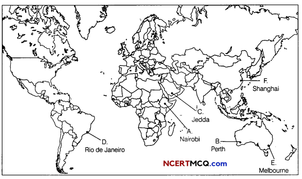
Question 10.
On the political map of the world, identify the following features (Attempt any 5). (1 × 5 = 5)
A. An airport in Africa
B. A major sea port
C. A major airport
D. A seaport in south America
E. A major seaport in Australia
F. A major seaport in China
Answer: