Check the below NCERT MCQ Questions for Class 10 Geography Chapter 3 Extra Questions and Answers Water Resources Pdf free download. https://ncertmcq.com/extra-questions-for-class-10-social-science/
Water Resources Class 10 Extra Questions Geography Chapter 3
Water Resources Class 10 Extra Questions And Answers Question 1.
Wherefrom the Brahmputra originates?
Answer:
From Tibet.
Class 10 Geography Chapter 3 Extra Questions And Answers Question 2.
In which direction does the Brahmaputra flow?
Answer:
The Brahmaputra flows in eastward direction parallel to the Himalayas.
Class 10 Geography Chapter 3 Extra Questions Question 3.
What does the Brahmputra do in Namecha Barwa?
Answer:
The Brahmputra reaching Namcha Barwa takes a U-turn and enters India in Arunachal Pradesh.
Water Resources Class 10 1 Mark Questions Question 4.
What is a river basin?
Answer:
A river basin is meant by the area which is drained by a single river system. This is also known as drainage basin.
Class 10 Geography Chapter 3 One Mark Questions Question 5.
Name two saltwater lakes on the eastern coast of India.
Answer:
- The chilka-in Orissa.
- The Pulicat-in Tamil Nadu.
![]()
Class 10 Geography Chapter 3 Extra Questions In Hindi Question 6.
In which states does the Brahmaputra flow in India?
Answer:
- Arunachal Pradesh,
- Assam.
Water Resources Class 10 Important Questions And Answers Question 7.
By which name the mainstream of Ganga is known in Bangladesh?
Answer:
Padma.
Water Resources Class 10 Questions And Answers Question 8.
When is the Ganga as Jamuna?
Answer:
In Bangladesh when the Brahmaputra joins the Ganga, it is known as Jamuna.
Class 10 Geography Chapter 3 Questions And Answers Question 9.
Where does the Jhelum fall into the Indus?
Answer:
A little over Mithankot.
Water Resources Class 10 Very Short Questions And Answers Question 10.
What is meant by the dendritic pattern of streams?
Answer:
The dendritic pattern of streams indicate the streams resembling like the branches of a tree.
Extra Questions Of Water Resources Class 10 Question 11.
Point out the prominent features of the Ganga-Brahmaputra delta.
Answer:
- It is the largest delta of the world.
- It is one of the most fertile areas of the world.
- It is a triangular-shaped area.
- It is a well-watered area.
- The lower part of this delta is marshy.
- Mangroves are found only in this place of the whole India.
Water Resources Class 10 Short Questions And Answers Question 12.
How would you differentiate between a glacier and a river?
Answer:
| Glacier | River |
| 1. Glaciers are in the solid form. | 1. River are in liquid form. |
| 2. Glaciers look like a mountain of ice. | 2. Rivers may be seen flowing. |
| 3. Glaciers move very slowly. | 3. Rivers move with a greater speed |
| 4. The movement of a glacier is not discernible. | 4. The movement of a river is easily discernible. |
Class 10 Water Resources Extra Questions Question 13.
How the lakes are formed?
Answer:
- Lakes are formed in the mountainous area when the glaciers block the valleys and large amount of water is collected in that place.
- The violent movements of the earth, like the earthquakes, also create lakes when the depressions formed on the crust of the earth are filled with rainwater.
- Human beings also form lakes for various purpose.
Water Resources Class 10 Questions And Answers Pdf Question 14.
What is meant by the Indus water treaty?
Answer:
Indus water treaty is a treaty between India and Pakistan. This treaty is about the sharing of the waters of the Indus system. According to this treaty, India can use only 20% of the total of the water carried by the Indus river system.
![]()
Class 10 Geography Chapter 3 Important Questions Q. 15.
Which are the important peninsular riv¬ers of India?
Or
Give a brief account of the different peninsu¬lar rivers of India.
Answer:
The Narmada: It rise from Amarkantak in Madhya Pradesh. It flows west-southward in a trough for a distance about 1300 km. The Narmada gorge in the marble rocks of Madhya Pradesh is very famous for its beauty.
The Tapi: It rises from the Betul district of Madhya Pradesh. It flows in a trough parallel to the Narmada. However, it is smaller in size than of the Narmada.
The Godavari: It is also known as the Dakshin Ganga and Vridha Ganga. It is the largest among the peninsular rivers of India. It rises in Nashik district of Maharashtra. Its length is about 15000 km. It drains into the Bay of Bengal.
The Mahanadi: It rises in Chattisgarh and flows through Orissa and reaches the Bay of Bengal.
The Krishna: It rises from the spring near Mahabaleshwar. It flows for nearly about 1400 km. Its drainage basin in shared by Maharashtra, Karnataka and Andhra Pradesh.
The Kaveri: It rises in the Brahmagir ranges of the Western Ghats. It flows over 800 km. Near the Kaveripatnam, it reaches the Bay of Bengal.
Question 16.
What is the reason of the water pollution? How the pollution level can be reduced?
Or
Suggest some measures to reduce the pollution of water.
Answer:
Water pollution indicates that the water is not pure and safe for the health. Today many factors are causing the water pollution. It is very dangerous for health as well as for the environment. The large number of the dead fishes found in Yamuna at Agra proved it. Factories, specially the chemical industries, paper mills, sugar mills, tanneries etc. are causing the water to be polluted. The disposal of sewage of urban areas into the rivers also lead to this pollution.
As for example, the Najafgarh Nala in Delhi may be taken. Water is also being polluted by the use of pesticides and fertilizers in the nearby fields.
To reduce the pollution level, the following steps should be taken:
- The effluents from the factories should not be allowed to fall into the rivers.
- No chemical industry, paper mill, sugar mill should be allowed to stagnate their effluents on land at any cost. So that it do not pollute the underground water through seepage.
- Effluents of the mills and the factories should be scientifically treated and recycled to be used again.
- Sewage should be treated and diverted to irrigate the fields and the wastelands.
- Oil spills from tankers must not be allowed to enter any water form or river. In fact being a little more aware and taking care of otherwise looking small matters, magic can be created. It would surely make the rivers and other water bodies pollution-free. It will also do magic for our environment.
Glacier:
- Glaciers are in solid form.
- Glaciers look like a mountain of ice.
- Glaciers move very slowly.
- The movement of a glacier is not discernible.
![]()
Multiple Choice Questions
1. Choose the right answer from the four alternatives given below;
Question 1.
The river Indus rises from the following:
(a) Mansarovar
(b) Gangotri
(c) Nasik
(d) Mahabaleswar.
Answer:
(a) Mansarovar
Question 2.
The Ganga is also known as:
(a) Krishna
(b) Bhagirathi
(c) Narmada
(d) Kaveri
Answer:
(b) Bhagirathi
Question 3.
The following is a peninsular riven
(a) The Ganga
(b) The Tapi
(c) The Indus
(d) The Brahmaputra.
Answer:
(b) The Tapi
Question 4.
The following is the largest peninsular river:
(a) Mahanadi
(b) Krishna
(c) Godawari
(d) Narmada.
Answer:
(c) Godawari
![]()
Question 5.
The following is the range from where the river Tapi rises:
(a) Satpura
(b) Aravalli
(c) Vindhya
(d) None of these.
Answer:
(d) None of these.
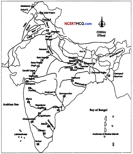
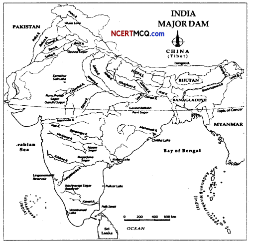
Map Skills
Question 1.
On the outline may of India, show major dams.
Answer:
Question 2.
On the outline map of India locate the following: Satluj, Damodar, Krishna, Godavari, Mahanadi and Brahmputra.
Answer: