Here we are providing Class 11 Geography Important Extra Questions and Answers Chapter 4 Distribution of Oceans and Continents. Important Questions for Class 11 Geography are the best resource for students which helps in class 11 board exams.
Important Questions for Class 11 Geography Chapter 4 Distribution of Oceans and Continents
Distribution of Oceans and Continents Important Extra Questions Very Short Answer Type
Question 1.
What is Pangaea?
Answer:
All landmasses of the world have been formed from one super¬continent called Pangaea.
Question 2.
Who first propounded the theory of continental drift?
Answer:
Alfred Wegner propounded the theory of continental drift in 1912.
Question 3.
Which plate is composed of mainly oceanic crust?
Answer:
The Pacific plate is composed of mainly oceanic crust.
Question 4.
How did the Himalayas rise?
Answer:
The collision between the Indian Plate and the Eurasian plate took place north of the Indian plate giving rise to the Himalayas.
Question 5.
What is the evidence in support of continental drift theory?
Answer:
- Geological matching
- Palaeoclimatic unity, and
- Palaeornagnetism.
Question 6.
Name the continents into which the supercontinent, Pangaea, got split.
Answer:
They are Laurasia and Gondwanaland.
Question 7.
How many years ago Pangaea, the supercontinent has evolved?
Answer:
Pangaea, the supercontinent, had evolved some 280, million years ago.
Question 8.
What are hot spots?
Answer:
The centers of volcanic activity are called hot spots.
Question 9.
Name the three kinds of boundaries based on their Relative motion.
Answer:
- Zones or margins of divergence or spreading,
- Margins of convergence, and
- Fracture zones or transform faults.
Question 10.
How many plates the lithosphere is divided into?
Answer:
Seven plates.
Question 11.
The collision between which two plates gave rise to the Himalayas?
Answer:
The collision between Indian and Eurasian plates gave rise to the Himalayas.
Question 12.
Name two fossils that tell us that continents were once united.
Answer:
The fossils of the plant Glossopteris and animals Mesosaurus and Lystosaurus, suggests that these continents were once joined.
Question 13.
What is Palaeornagnetism?
Answer:
It is the fossil magnetism evident today in igneous rocks such as magnetite, hematite, pyrrhotite, etc.
Question 14.
What is the Pacific plate?
Answer:
The latest plate in terms of its formation or origin.
Question 15.
What do you understand by the spreading of crust from the ridge and the widening of the ocean basin?
Answer:
It is the seafloor spreading.
Question 16.
Name the northern and southern parts of Pangaea.
Answer:
Laurasia and Gondwanaland.
Question 17.
Name the sea separating Laurasia and Gondwanaland.
Answer:
The Tethys sea.
Question 18.
In which parts Pangaea was split?
Answer:
Pangaea was split into northern continent Laurasia and Southern continent, Gondwanaland.
Question 19.
Name the original supercontinent. When was it formed?
Answer:
Pangaea. It was formed about 280 million years ago.
Question 20.
State three causes of plate movements.
Answer:
- Thermal convection,
- Hot spots of volcanic activity,
- Movement of currents.
Question 21.
What is meant by sea-floor spreading?
Answer:
The crust spreads away from the ridge and the ocean basin widens. This phenomenon is known as sea-floor spreading.
Question 22.
Name the process in which one plate overrides the other and the overriding plate slips down into the mantle and is submerged.
Answer:
Subduction.
Question 23.
What is thermal convection?
Answer:
It acts as a driving force for the movement of plates.
Question 24.
Name the four different types of plate interactions.
Answer:
Spreading, collision, subduction, and transform.
Question 25.
How was drifting of continents caused?
Answer:
It was caused by two forces :
- pole fleeing force, and
- tidal force.
Distribution of Oceans and Continents Important Extra Questions Short Answer Type
Question 1.
How do lithosphere plates behave along the transform fault?
Answer:
The lithospheric plates slide over each other, neither creating nor destructing any landmass. Instead, the. friction arising from the f* movement of the plates usually causes severe earthquakes and earth tremors.
Question 2.
Why do geographers focus their attention on plate boundaries?
Answer:
Geographers focus their attention on plate boundaries because each plate is a tectonic plate. It is rigid and moves as a single unit. Nearly all major tectonic activity occurs along the plate boundaries.
Question 3.
What does the term ‘supercontinent’ refer to?
Answer:
The term ’supercontinent’ refers to a single common geological landmass called Pangaea. It has been proposed that all landmasses of the world had formed from this ‘supercontinent’. Pangaea had evolved some 280 million years ago, at the end of the Carboniferous period and by mid-Jurassic age, 150 million years ago. Pangaea land split into Laurasia, the northern continent, and Gondwanaland, the southern continent. About 65 million years ago, i.e. at the end of the cretaceous, bound mainland were further broken up to give rise to several other continents such as South America, Africa, Australia, and Antarctica.
Question 4.
Discuss the causes of plate movement.
Answer:
Sub-crustal convection currents invoke the mechanism of thermal convection that acts as a driving force for the movement of plates. Hot currents rise, then cool as they reach the surface. At the same time, cool currents sink down. This convectional movement moves the crustal plates. .. Owing to current movements, the rigid plates of the lithosphere, which ‘float’ on more mobile asthenosphere, are in constant motion.
Question 5.
What is a geological time-scale?
Answer:
The chronology of the geological history’ of the earth is revealed by its rocks. Geological time scale indicates the hierarchy of time periods during which different rocks of the earth have formed.
Question 6.
What is subduction?
Answer:
The process in which the overridden plate slips down into the mantle and is submerged is known as subduction. Besides volcanism and shallow to deep-focus earthquakes, boundaries also formed deep trenches and folded mountains.
Question 7.
What is polar wandering?
Answer:
There has been a periodic change in the position of the magnetic pole. These changes are recorded in rocks by way of permanent magnetism. Unraveling of the signatures of such changes in the geologically old rocks by scientific methods provides the changing position of poles in geological time scale. It is known as ‘polar wandering’. It demonstrates that the continents have frequently moved and changed their direction of motion from time to time.
Question 8.
Account for the formation of the Himalayas according to the theory of plate tectonics in three points.
Answer:
- South-east Indian ocean ridge collided between the Indian plate and European plate. The Indian plate gave rise to the Himalayas.
- The suture between the Indian and Eurasian plates in the Himalayan region has been along the Indus and Brahmaputra.
- The mid-Indian ocean ridge has been spreading faster.
Question 9.
What is ‘Zolrt of Convergence’?
Answer:
Zone of Convergence is the boundary along which the edge of ‘ one plate overrides the other. It produces deep trenches and folds mountains. Volcanoes and deep-focus earthquakes mark it.
Question 10.
Describe the driving force for the movement of plates.
Answer:
The sub-crustal convection currents invoke the mechanism of thermal convection that acts as a driving force for the movement of plates. As these currents reach the surface, the hot current rises, then cools. Sometimes, cooler currents sink down. This type of convectional movement causes the movement of crustal plates.
Question 11.
Name the major plates of the earth. Which plate is composed of the oceanic plate?
Answer:
Pacific plate, Eurasian plate, Indo-Australian plate, African plate, North American plate, South American plate, and Antarctica plate are the major plates of the earth.
The zone of divergence is the boundary along which the plate is composed of mainly oceanic crust. It is known as the Pacific plate.
Question 12.
What is palaeoclimatic unity?
Answer:
The uniformity in the nature of the sediment in the biological past indicates that these continents were together in the geological past and experienced similar climatic conditions. It is the native of glacial deposits of the separated continents indicating that these continents were together in the geological past and experienced similar climatic conditions.
Distribution of Oceans and Continents Important Extra Questions Long Answer Type
Question 1.
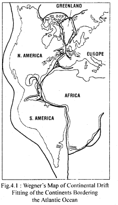
What do you mean by ‘jig-saw-fit’? Describe the similarities found on the east and west coasts of the Atlantic ocean. What do they suggest?
Answer:
The ‘jig-saw-fit’ means the landmasses on the east and west coast of the Atlantic ocean can be fitted together. There are many similarities found on the two coasts :
- The Gulf of Guinea can be fitted into Cape San-Rogue of Brazil, the shoulder of Africa can be fitted into Gulf of Mexico, Western Europe and Eastern coast of North America along with Greenland can be fitted together.
- Gold deposits of Ghana lands are found on the east and in Brazil on the west.
- The glacial deposits are found in all landmasses of Gondwana land.
These similarities suggest that these continents were together in the geological past.
Question 2.
Discuss the Continental Drift Theory.
Answer:
Continental Drift Theory was proposed by Alfred Wegner in 1912. He postulated that all landmasses of the world have been formed from one super-continent called Pangaea.
The supercontinent, Pangaea, had evolved some 280 million years ago, at the end of the Carboniferous period and by the mid-Jurrasic age, 150 million years ago. Pangaea had split into a northern continent, Laurasia, and a southern continent Gondwanaland. About 65 million years ago, i.e., at the end of the Cretaceous, Gondwanaland further broke up to give rise to several other continents, such as South America, Africa, Australia, and Antarctica. Thus, the present distribution of the continental masses and the oceans are the n .uit of fragmentation of one or more pre-existing masses. These landmasses have drifted apart the intervening hollows having been occupied by the oceans.
There are several pieces of evidence that suggest the existence of Pangaea. This evidence is available in the form of geological watching, palaeoclimatic units, and paleomagnetism.
Question 3.
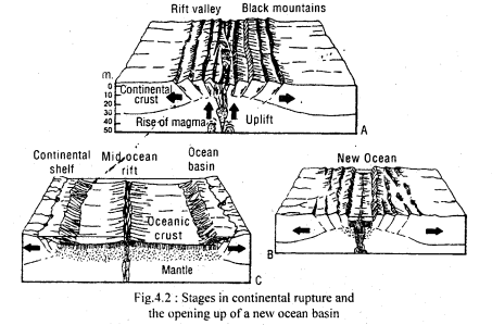
Describe sea-floor spreading in brief.
Answer:
The present distribution of continents has taken place in the last 65 million years. The drift of continents still continues. The ridges down the middle of ocean floors have been emitting lava continuously. Those mid-oceanic ridges are cracks on the floor of the ocean where molten rocks push up to form a new crust. The crust spreads among the ridge and the ocean basin widens. This phenomenon is known as sea-floor spreading. The Atlantic ocean is getting smaller and the Red Sea is the part of a crack in the crust that will widen to produce new ocean millions of years ahead in the future. In the past, the widening of the South Atlantic ocean has separated Africa and South America.
Question 4.
Explain the plate tectonic theory and its mechanism.
Answer:
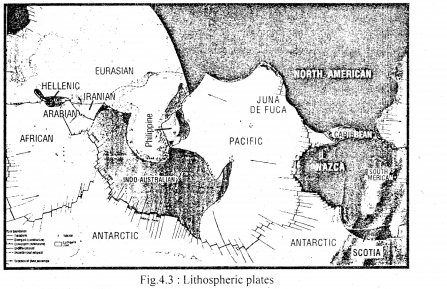
Plate tectonic theory proves that the earth’s crust consists of several plates that carry continents and the ocean floors and float on the asthenosphere, moving very slowly, the movement probably resulting from currents in the asthenosphere. As shown in fig., the lithosphere is broken into seven major plates. They include :
- Pacific plate
- Eurasian plate
- Indo-Australian plate
- African plate
- North American plate
- South American plate
- Antarctic plate
The latest among these is the Pacific plate which is composed of oceanic crust almost entirely. The other plates have both continental and ocean crust. No plate consists of only continental crust. Plates range in thickness from about 70 km. beneath oceans to 150 km. under continents. Each tectonic plate is rigid and moves on a single unit. Nearly all major tectonic activities occur along the plate boundaries.
Based on the relative motion of plates, three kinds of plate boundaries have been recognized. They are :
1. Zones of divergence: These are boundaries along which plates separate and in the process of separation molten materials upwell. This is commonly observed along linear ocean edge where the new lithosphere is created in the form of new ocean floors. Active volcanism and shallow focus earthquakes make such boundaries,
2. Zones of convergence: There are the boundaries along which, the edge of one plate overrides the other. The overridden plate slips down into the mantle and is absorbed. This process is known as subduction.
3. Fracture zones or Transform faults: The plates slide past each other effect creating or destructing the boundaries. However, shallow focus earthquakes may result due to this friction.
Question 5.
Describe the main features of the Indian plate.
Answer:
Indian ocean floor presents striking topography consisting of a number of elevated ridges and plateaus. Two of the ocean ridges, namely, the Mascarene Plateau, Chagos-Maldweep-Lakshadweep island ridge are said to be the volcanic tracts of two hot spots. The Northward extension of Ninety-east Ridge indeed in the trench which consumed the seafloor to the north of the Indian continental mass. The Chagos- Lakshadweep ridge linked the ancient Carlsberg ridge with the Southeast Indian ridge during the Eocene period (50 million years ago).
Consequent to the Carlsberg-Southeast Indian ocean ridge, the collision between the Indian plate and the Eurasian plate took place north of the Indian plate giving rise to the Himalayas. The suture between Indian and Eurasian plates in the Himalayan region has been along the Indus and Brahmputra rivers.