Here we are providing Class 12 Geography Important Extra Questions and Answers Chapter 9 Planning and Sustainable Development in Indian Context. Geography Class 12 Important Questions are the best resource for students which helps in class 12 board exams.
Class 12 Geography Chapter 9 Important Extra Questions Planning and Sustainable Development in Indian Context
Planning and Sustainable Development in Indian Context Important Extra Questions Very Short Answer Type
Question 1.
When was the First Five Year Plan started? State its period.
Answer:
In 1951; 1951-56.
Question 2.
When has the 10th Five Year Plan ended?
Answer:
31.3.2007.
Question 3.
State two approaches of planning?
Answer:
Sectoral and Regional.
Question 4.
What was the period of plan holiday?
Answer:
1966-67, 1968-69.
Question 5.
Examine the twin environmental problems that have emerged in the ‘Indira Gandhi Canal Command Area’. (C.B.S.E. Outside Delhi 2017)
Answer:
The problems that have emerged in the ‘Indira Gandhi Canal Command area’ are water logging and soil salinity.
Question 6.
How much area can be irrigated in drought prone areas?
Answer:
Less than 30%.
Question 7.
Name two hilly areas of Hill development.
Answer:
Darjeeling and Nilgiris.
Question 8.
In which district of Himachal Pradesh is Bharmaur tribal area located?
Answer:
In Bharmaur and Holi Tehsil of Chamba District.
Question 9.
Name two hill ranges in Bharmaur region.
Answer:
Pir Punjal and Dhaula Dhar Ranges.
Question 10.
State the population and population density of Bharmaur region.
Answer:
Total population = 32246 and the density of population = 20 person per sq. km.
Question 11.
From which Barrage was the Indira Canal taken out ?
Answer:
Harike Pattan.
Question 12.
When was NITI Aayog formed?
Answer:
On 1st January 2015.
Question 13.
What was the main objective to implement the Fourth Five Year Plan for the people in drought prone areas ? (C.B.S.E. 2009)
Answer:
The main objective was to provide employment to the people in drought prone areas.
Question 14.
In which Five Year Plan of India was the Hill Area Development programme initiated?
Answer:
Hill Area Development programme was initiated during the Fifth Five Year Plan (1974-75 upto 1977-78) to harness indiginous resources.
Question 15.
What is sectoral planning ? (C.B.S.E. 2013)
Answer:
Development of various sectors of the economy.
Question 16.
How has the Gaddi Tribal community of Bharamaur region maintained the district identity ? (C.B.S.E. 2013)
Answer:
By practising Transhumance.
Planning and Sustainable Development in Indian Context Important Extra Questions Short Answer Type
Question 1.
What do you mean by Planning? How is it a sequential process ?
Answer:
Planning is the process of evolving a sequence of actions, which are designed to solve problems in future. The planning problems vary but tend to be primarily economic and social; the planning period also varies according to the type and level of planning; but all planning involves a sequential process, which can be conceptualised into a number of stages.
Question 2.
In which areas Hill Area Development Programmes was intiated ?
Answer:
Hill Area Development Programme. Hill Area Development Programmes were initiated during the Fifth Five Year Plan covering 15 districts comprising all the hilly districts of Uttar Pradesh (present Uttarakhand), Mikir Hill and North Cachar hills of Assam, Darjeeling district of West Bengal and Nilgiri district of Tamil Nadu.
The National Committee on the Development of Backward Area in 1981 recommended that all the hill areas in the country having height above 600 m and not covered under tribal sub-plan, be treated as backward hill areas.
Question 3.
What steps have been recommended for development of backward areas ?
Answer:
The National committee on the development of Backward areas have recommended the following steps:
- All the people should get benefits.
- To develop the local resources and talent.
- To make the subsistence economy investment oriented.
- Backward areas should not be exploited in internal trade.
- To benefit the labourers by setting the markets.
- To maintain the ecological balance.
Question 4.
Which aspects have been developed in hill area development ?
Answer:
The detailed plans for the development of hill areas were drawn keeping in view their topographical, ecological, social and economic conditions. These programmes aimed at harnessing the indigenous resources of the hill areas through development of horticulture, plantation agriculture, animal husbandry, poultry, forestry and small-scale and village industry.
Question 5.
What were the objectives of Drought Prone Area Programme ?
Answer:
Drought Prone Area Programme. This programme was initiated during the Fourth Five Year Plan wdth the objectives of providing employment to the people in drought-prone areas and creating productive assets. Initially this programme laid emphasis on the construction of labour-intensive civil works. But later on, it emphasised on irrigation projects, land development programmes, afforestation, grassland development and creation of basic rural infrastructure such as electricity, roads, market, credit and services.
Question 6.
Which areas are Drought Prone Areas in India ?
Answer:
Planning Commission of India (1967) identified 67 districts (entire or partly) of the country prone to drought. Irrigation Commission (1972) introduced the criterion of 30 per cent irrigated area and demarcated the drought prone areas.
Broadly, the drought-prone area in India are spread over semi-arid and arid tract of Rajasthan, Gujarat, Western Madhya Pradesh, Marathwada region of Maharashtra, Rayalseema and Telangana plateaus, Karnataka plateau and highlands and interior parts of Tamil Nadu. The drought prone areas of Punjab, Haryana and north-Rajasthan are largely protected due to spread of irrigation in these regions.
Question 7.
What do you mean by Indira Gandhi Canal Command Area? Describe its location and extent.
Answer:
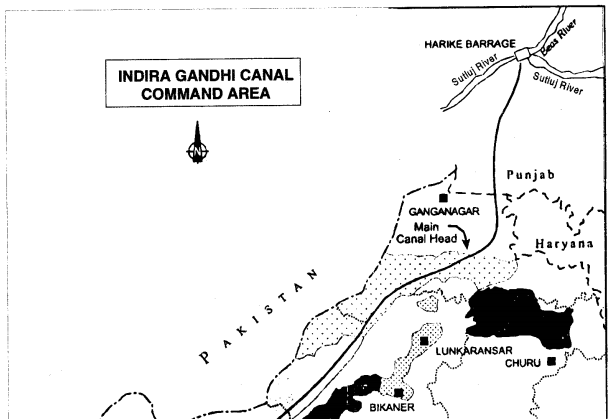
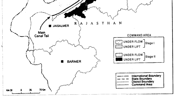
Indira Gandhi Canal Command Area
The areas through which the Indira canal has been built and will get the benefits of it, are called its command area. Indira Gandhi Canal Project is a gigantic human effort to transform a part of desert land into a land of prosperity and plenty.
It is one of the largest canal systems of the world. The command area of Indira Gandhi Canal is located in north-western part of the Thar desert of Rajasthan in the districts of Ganganagar, Bikaner, Jaisalmer, Barmer, Jodhpur and Churu. It is strecthed over an area of 2,37,725 sq. km., an approximate area of 525 x 45 sq. km along the border of Pakistan. The Indira Gandhi Main Canal runs parallel to the Pakistan border for an approximate distance of 38 km from north-east to south-west.
Question 8.
When was Indira Gandhi canal started? Name the states through which I this canal runs.
Answer:
Origin of Indira Canal
(i) Origin: Work on the Indira Gandhi canal began on 31 March, 1958.
(ii) Place of origin: This canal originates from Harike barrage near the confluence of Satluj and Beas rivers in Ferozpur district of Punjab.
(iii) Capacity: It is 40 metres wide at the bottom and 6.4 metres deep. The carrying capacity of canal is 18,500 cusecs of water at its head. According to a proposal in 1981, Rajasthan was allocated 8.6 million acre feet ofRavi-Beas surplus water. The Indira Gandhi Canal envisages the utilisation of 7.6 million acre feet of water allocated to Rajasthan.
(iv) Sharing States: The Indira Gandhi Canal is feeder up to a length of 204 km and traverses for a length of 150 km in Punjab and 19 km in Haryana where it does not have any outlet.
(v) Head of Canal: The head of the main canal is located near Masitanwali in Hanumangarh tehsil of Ganganagar district. The tail of the 445 km long main canal is located near Mohangarh in Jaisalmer district.
(vi) Command area: The Command Area of the canal is further extended till Gadra road in Barmer district, through Sagarmal Gopa branch. Construction work of the project is in progress and is being carried out into two states. Water was released in the main canal on 11 October 1967 and reached its tail on 1 January, 1987.
Question 9.
Describe the impact of irrigation on environment of command area.
Answer:
Impact of Irrigation on Environment.
Introduction of irrigation has brought about perceptible changes in agricultural landscape, and has increased agricultural production tremendously,
(i) Rise in water table. But it has led to environmental degradation in terms of water-logging and soil salinity. The ground-water table is rising at an alarming rate of 0.8 metre per year in most parts of Stage I. According to an estimate of the ground-water department, about 25 per cent of land under the command area in the vicinity of Ghaggar basin is critical area as the groundwater level in this area is less than 6 metres below surface level. About 50 per cent area of this region would be critical by the turn of this century if measures are not taken to arrest it.
(ii) Salinity in soils. In a large part of the command area in Stage I, soil salinity has arisen because of water-logging and the presence of strong salt regime in the soils.
(iii) Fertility of soil. This has adversely affected the soil fertility and agricultural productivity. This
problem is expected to be more serious in the command area of Stage II, where irrigation was introduced in mid-eighties. This part of the command area is underlain by hard pan of calcium carbonate and clay at a depth of few* metres which causes parched water table and water logging.
Question 10.
‘The development is a mixed bag of opportunit ies as well as [9nl; deprivations of India’. Support the statement with suitable examples.
(C.B.S.E. 2011)
Answer:
In India, development is marked by social discrimination and regional disparity. Present development has not been able to address the issues of social justice, regional imbalance and environment degradations. Development has effect on deteriorating human conditions. Environment pollution—air, soil, water have not only led to the tragedy of commons but also have threatened the existence of our society.
Thus, development in India is a mixed bag of opportunities as well as neglect and deprivation.
- Few metropolitans with small section of population have modern facilities.
- Large rural areas and slums in the urban areas do not have basic amenities.
- Different sections of the society do not have opportunities of development.
- Majority of Scheduled Castes, Scheduled Tribes, landless agricultural labourers, poor farmers, are the most marginalised lot.
- A large segment of female population is the worst sufferer among all.
Question 11.
Distinguish between sectoral planning and Regional planning.
Or
Examine the concept of Regional Planning.
Answer:
Generally, there are two approaches to planning, i.e. sectoral planning and regional planning.
1. Sectoral planning. The sectoral planning means formulation and implementation of the sets of schemes or programmes aimed at development of various sectors of the economy such as agriculture, irrigation, manufacturing, power, construction, transport, communication, social infrastructure and services.
2. Regional planning. There is no uniform economic development over space in any country. Some areas are more developed and some lag behind. This uneven pattern of development over space necessitates that the planners have a spatial perspective and draw the plans to reduce regional imbalance in development. This type of planning is termed as regional planning.
Question 8.
When was Indira Gandhi canal; started? Name the states through which At this canal runs.
Answer:
Origin of Indira Canal
(i) Origin. Work on the Indira Gandhi canal began on 31 March, 1958.
(ii) Place of origin. This canal originates from Harike barrage near the confluence of Satluj and Beas rivers in Ferozpur district of Punjab.
(iii) Capacity. It is 40 metres wide at the bottom and 6.4 metres deep. The carrying capacity of canal is 18,500 cusecs of water at its head. According to a proposal in 1981, Rajasthan was allocated 8.6 million acre feet of Ravi-Beas surplus water. The Indira Gandhi Canal envisages the utilisation of 7.6 million acre feet of water allocated to Rajasthan.
(iv) Sharing States. The Indira Gandhi Canal is feeder up to a length of 204 km and traverses for a length of 150 km in Punjab and 19 km in Haryana where it does not have any outlet.
(v) Head of Canal. The head of the main canal is located near Masitanwali in Hanumangarh tehsil of Ganganagar district. The tail of the 445 km long main canal is located near Mohangarh in Jaisalmer district.
(vi) Command area. The Command Area of the canal is further extended till Gadra road in Barmer district, through Sagarmal Gopa branch. Construction work of the project is in progress and is being carried out into two states. Water was released in the main canal on 11 October 1967 and reached its tail on 1 January, 1987.
Question 9.
Describe the impact of irrigation on environment of command area.
Answer:
Impact of Irrigation on Environment.
Introduction of irrigation has brought about perceptible changes in agricultural landscape, and has increased agricultural production tremendously,
(i) Rise in water table. But it has led to environmental degradation in terms of water-logging and soil salinity. The ground-water table is rising at an alarming rate of 0.8 metre per year in most parts of Stage I. According to an estimate of the ground-water department, about 25 per cent of land under the command area in the vicinity of Ghaggar basin is critical area as the groundwater level in this area is less than 6 metres below surface level. About 50 per cent area of this region would be critical by the turn of this century if measures are not taken to arrest it.
(ii) Salinity in soils. In a large part of the command area in Stage I, soil salinity has arisen because of water-logging and the presence of strong salt regime in the soils.
(iii) Fertility of soil. This has adversely affected the soil fertility and agricultural productivity. This problem is expected to be more serious in the command area of Stage II, where irrigation was introduced in mid-eighties. This part of the command area is underlain by hard pan of calcium carbonate and clay at a depth of few metres which causes parched water table and water logging.
Question 10.
‘The development is a mixed bag of opportunities as well as deprivations of India’. Support the statement with suitable examples. (C.B.S.E. 2011)
Answer:
In India, development is marked by social discrimination and regional disparity. Present development has not been able to address the issues of social justice, regional imbalance and environment degradations. Development has effect on deteriorating human conditions. Environment pollution air, soil, water have not only led to the tragedy of commons but also have threatened the existence of our society.
Thus, development in India is a mixed bag of opportunities as well as neglect and deprivation.
- Few metropolitans with small section of population have modern facilities.
- Large rural areas and slums in the urban areas do not have basic amenities.
- Different sections of the society do not have opportunities of development.
- Majority of Scheduled Castes, Scheduled Tribes, landless agricultural labourers, poor farmers, are the most marginalised lot.
- A large segment of female population is the worst sufferer among all.
Question 11.
Distinguish between sectoral planning and Regional planning.
Or
Examine the concept of Regional Planning.
Answer:
Generally, there are two approaches to planning, i.e. sectoral planning and regional planning.
1. Sectoral planning. The sectoral planning means formulation and implementation of the sets of schemes or programmes aimed at development of various sectors of the economy such as agriculture, irrigation, manufacturing, power, construction, transport, communication, social infrastructure and services.
2. Regional planning. There is no uniform economic development over space in any country. Some areas are more developed and some lag behind. This uneven pattern of development over space necessitates that the planners have a spatial perspective and draw the plans to reduce regional imbalance in development. This type of planning is termed as regional planning.
Question 12.
‘In India the Planning is still centralised’. Discuss and mention the subjects under it.
Answer:
In India, Planning is still centralized. National Development Council, consisting of the central cabinet, members of the Planning Commission and chief ministers of states and union territories set the policy of the planning. The Planning Commission is entrusted with the formulation of the national plans.
Subjects of national significance, such as defence, communication, railway, etc., come under the scope of Central Government, while vital elements of rural development, such as agriculture, power, education, health, social services, small-scale industries and development of roads and transport fall in the scope of the state government. In most cases, strategies, policies and programmes are formulated by the Planning Commission and states are simply asked to implement them.
Question 13.
What do you mean by “Target area’ and ‘Target group’? What programmes are being undertaken in these areas ?
Answer:
With the planning experience of about one and half decades, it was realised that regional imbalances in economic development were getting accentuated. In order to arrest the accentuation of regional and social disparties, the Planning Commission introduced the ‘target area’ and ‘target group’ approaches to planning.
Some of the examples of programmes directed towards the development of target areas are Command Area Development Programme, Drought Prone Area Development Programme, Desert Development Programme, Hill Area Development Programme.
The Small Farmers Development Agency (SFDA) and Marginal Farmers Development Agency (MFDA) which are the examples of target group programme. In the 8th Five Year Plan special area programmes were designed to develop infrastructure in hill areas, north-eastern states, tribal areas and backward areas.
Planning and Sustainable Development in Indian Context Important Extra Questions Long Answer Type
Question 1.
Describe the overview of planning prespective in India.
Answer:
After Independence, the Planning Commission stated the following Five Year Plans.
1. First Five Year Plan. The First Five Year Plan was launched in 1951 and covered the period, 1951-52 to 1955-56.
2. The Second and Third Five Year Plans. Second and Third Five Year Plans covered the period from 1956-57 to 1960-61 and 1961-62 to 1965-66 respectively.
3. Plan Holiday. Two successive droughts during mid-sixties (1965-66 and 1966-67) and war with Pakistan in 1965 forced a plan holiday in 1966-67 and 1968-69.
4. Rolling Plans. This period was covered by annual plans, which are also termed as rolling plans.
5. The Fourth Five Year Plan. The Fourth Five Year Plan began in 1969-70 and ended in 1973-74.
6. The Fifth Five Year Plan. Following this the Fifth Five Year Plan began in 1974-75 but it was terminated by the then government one year earlier, i. e., in 1977-78.
7. The Sixth Five Year Plan. The Sixth Five Year Plan took off in 1980.
8. The Seventh Five Year Plan. The Seventh Five Year Plan covered the period between 1985 and 1990.
9. The Eight Five Year Plan. Once again due to the political instability and initiation of liberalisation policy, the
Eighth Five Year Plan got delayed. It covered the period, 1992 to 1997.
10. The Ninth Five Year Plan. The Ninth Five Year Plan covered the period from 1997 to 2002.
11. The Tenth Five Year Plan. The Tenth Plan began in 2002 and ended on 31.3.2007.
12. The Eleventh Plan. The Eleventh Five Year Plan covered the period of 2007 to 2012.
13. The Twelfth Five Year Plan. The Twelfth Five Year Plan started on 2012 and currently in progress.
Question 2.
Describe the physical environment of Bharmaur regions.
Answer:
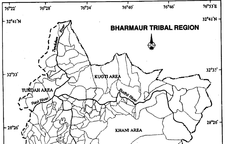
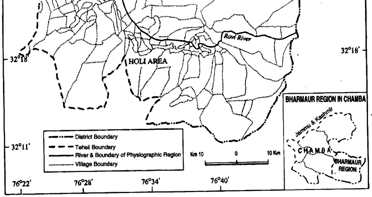
1. Location and Area. This region lies between 32° 11′ N and 32°41′ N latitudes and 76° 22′ E and 76° 53’E longitudes and is spread over an area of about 1,818 sq. km.
2. Relief. The region mostly lies between 1,500 m to 3,700 m above the mean sea level. This region popularly known as the homeland of Gaddis is surrounded by lofty mountains on all sides. It has Pir Panjal in the north and Dhaula Dhar in the south. In the east, the extension of Dhaula Dhar converges with Pir Panjal near Rohtang Pass.
3. River. The river Ravi and its tributaries the Budhil and the Tundahen, drain this territary, and carve out deep gorges. These rivers divide the region into four physiographic divisions called Holi, Khani, Kugti and Tundah areas.
4. Climate. Bharmaur experiences freezing weather conditions and snowfall in winter. Its mean monthly temperature in January remains 4°C and in July 26°C.
Question 3.
Describe the development in Bharmaur integrated Tribal region and state their effects. (C.B.S.E. 2014)
Or
Examine the importance of ‘Integrated Tribal Development Project’
Answer:
implemented in Bharmaur region of Himachal Pradesh. (C.B.S.E. 2016)
What was the main aim of the ‘Tribal Sub-Plan’ introduced in 1974 in Bharmaur area? Review its contribution in the development of the Bharmaur region. (CBSE Outside Delhi 2017)
Answer:
Case Study-Integrated Tribal Development Project in Bharmaur Region.
1. Social life. Bharmaur tribal area comprises Bharmaur and Holi tehsils of Chamba district of Himachal Pradesh. It is a notified tribal area since 21 November 1975. Bharmaur is inhabited by ‘Gaddi’, a tribal community who have maintained a distinct identity in the Himalayan region as they practised transhumance and conversed through Gaddiali dialect.
Bharmaur tribal region has harsh climate conditions, low resources base and fragile environment. These factors have influenced the society and economy of the region. According to the 2001 census, the total population of Bharmaur sub-division was 37.246, i.e., 20 persons per sq. km. It is one of the most (economically and socially) backward areas of Himachal Pradesh. Historically, the Gaddis have experienced geographical and political isolation and socio-economic deprivation. The economy is largely based on agriculture and allied activities such as sheep and goat rearing.
2. Developmental Programmes. The process of development of tribal area of Bharmaur started in 1970s when Gaddis were included among ‘scheduled tribes’. Under the Fifth Five Year Plan, the tribal sub-plan was introduced in 1974 and Bharmaur was designated as one of the five Integrated Tribal Development Projects (ITDP) in Himachal Pradesh.
This area development plan was aimed at improving the quality of life of the Gaddis and narrowing the gap in the level of development between Bharmaur and other areas of Himachal Pradesh. This Plan laid the highest priority on development of transport and communications, agriculture and allied activities, and social and community services.
3. Objectives. The most significant contribution of tribal sub-plan in Bharmaur region is the development of infrastructure in terms of schools, healthcare facilities, portable water, roads, communications and electricity. But the villages located along the river Ravi in Holi and Khani areas are the main beneficiaries of infrastructural development. The remote villages in Tundah and Kugti areas still do not have sufficient infrastructure.
4. Social benefits. The social benefits derived from ITDP include tremendous increase in literacy rate, improvement in sex ratio and decline in child marraige.
(i) The female literacy rate in the region increased from 1.88 per cent in 1971 to 42.83 per cent in 2001.
(ii) The difference between males and females in literacy level, i.e., gender inequality, has also declined.
(iii) Traditionally, the Gaddis had subsistence agricultural, i.e., cumpastoral economy having emphasis on foodgrains and livestock production. But during the last three decades of twentieth century, the cultivation of pulses and other cash crops has increased in Bharmaur region. But the crop cultivation is still done with traditional technology.
(4) The declining importance of pastoralism in the economy of the region can be guaged from the fact that at present only about one-tenth of the total households practise transhumance. But the Gaddis are still very mobile as a sizeab . auction of them migrate to Kangra and surrounding areas during winter to earn their livings from wage labour.
Question 4.
Write an essay on sustainable development.
Answer:
Natural resources are a kind of assets which are double edged. They provide raw materials and energy for development; they also form a part of the environment which influences health and vitality. Wise use of the resources is therefore essential for human survival and development. The key lies in sustainable development which Mahatma Gandhi advocated as early as 1908.
Sustainable development refers to a process of development wherein the quality of the environment is maintained by the use of exhaustible resources. This is to ensure the quality of the total stock of all forms of wealth (including environmental wealth) must not be depleted. Many forms of development erode the environmental resources upon which they are based; which in turn, undermines present economic development and reduces future possibilities drastically. Therefore, sustainable development should keep in view the stability of the ecosystem.
With this view the International Union of Conservation of Nature has defined sustainable development as ‘improving the quality of human life while living within the carrying capacity of the supporting ecosystem. Thus the question is not simply of sustenance of life but of good quality of life.
The processes of human-environment interaction depend upon the level of technology and institutions nurtured by a society. While the technology and institutions have helped in increasing the pace of human-environment interaction, the momentum thus generated, in return has accelerated technological progress and transformation and creation of institutions. Hence, development is a multidimensional concept and signifies the positive, irreversible transformation of the economy, society and environment.
The concept of development is dynamic and has evolved during the second half of twentieth century. In the post World War II era, the concept of development was synonymous to economic growth which is measured in terms of temporal increase in Gross National Product (GNP) and per capita income/per capita consumption.
But, even the countries having high economic growth, experienced speedy rise in poverty because of its unequal distribution. So, in 1970s, the phrases such as redistribution with growth and equity were incorporated in the definition of development.
While dealing with the questions related to redistribution and equity, it was realised that the concept of development cannot be restricted to the economic sphere alone. It also includes the issues such as improving the well-being and living standard of people, availing of the health, education and equality of opportunity and
ensuring political and civil rights. By 1980s, development emerged as a concept encapsulating wide¬spread improvement in social as well as material well being of all in a society.
The notion of sustainable development emerged in the wake of general rise in the awareness of environmental issues in the late 1960s in Western World. It reflected the concern of people about undesirable effects of industrial development on the enviornment. The publication of ‘The Population Bomb’ by Ehrlich in 1968 and ‘The Limits to Growth’ by Meadows and others in 1972 further raised the level of fear among environmentalists in particular and people in general.
This sets the scenario for the emergence of new models of development under a broad phrase ‘sustainable development.’Concerned with the growing opinion of world community on the environmental issues, the United Nations established a World Commission on Environment and Development (WCED) headed by the Norwegian Prime Minister Gro Harlem Brundtland.
The Commission gave its report (also known as Brundtland Report) entitled ‘Our Common Future’ in 1987. The report defines sustainable development as a “development that meets the needs of the present without compromising the ability of future generations to meet their own needs.”
Question 5.
What changes have been brought in western Rajasthan due to the Indira Gandhi Canal ?
Answer:
Command Area Development Programme
The Command Area Developmet Programme is an integrated area development approach towards the command areas of major and medium irrigation projects in the country. This programme is aimed at bridging the gap between created irrigation potential and its utilisation.
It is one of the major irrigation projects in India where this programme was introduced at the earliest. The importance of this programme is all the more in this command area because it requires efficient utilisation of irrigation water and overall economic and ecological development.
1. To check desertification. Due to scarcity of rainfall, Thar desert is rapidly advancing towards adjoining states. By afforestation and pasture development, the advance of this desert has been arrested.
2. Drinking water. The water table is low in this area. Fresh water is supplied to rural areas.
3. Development of transport system. This transport system is inadequate due to sandy area. This project will help in the development of transport.
It will provide communication and civic amenities which include construction of roads, connecting the settlements with markets, construction of new markets and supplying drinking water.
4. Agricultural development. Rajasthan is a man-made desert. Agriculture is possible in fertile areas. Irrigation will help in cultivation of wheat, sugarcane, etc. It is estimated that foodgrains worth ? 400 crore can be produced in this area. It will overcome problem of famines.Farm development includes surveying and planning water course lining, land levelling, shaping and reclaimation of degraded lands.
5. Industrial development. About 1200 cusecs water will be supplied to agro-based industries.
6. Irrigation. On its completion, the canal will be able to irrigate 14 Lakh hectares of land.
Implementation of this programme has helped in bringing the land under irrigation rapidly, increase
in water-use efficiency, agricultural production and productivity.
7. Afforestation. Afforestation and pasture development which includes canal side and roadside plantation, block plantation near new settlements, sand dune stabilisation and pasture development on culturable waste land.
8. Cropping pattern. Deficiency in soil-moisture has been a limited factor for agricultural development in western Rajasthan. Farmers can raise crops during kharif season only and a large tract of cultivable land lies uncropped in the form of cultivable waste land and fallow land. Introduction of irrigation has helped in increasing the net sown and double cropped areas.
In this region before introduction of irrigation, drought-resistant crops such as bajra, guar, moong, moth and gram occupied about 95 per cent of the gross cropped area. The cropping pattern of the region has changed drastically with the introduction of irrigation. As commercial crops such as cotton, groundnut, wheat and mustard have come up rapidly and occupy about 65 per cent of the gross cropped area in Stage I of the Canal Command Area.
Wheat occupied about one-fourth of the gross cropped in the Canal Command Area in 1984-85 followed by cotton, mustard and guar. Groundnut is coming up as a major irrigated crop in kharif season in the lower parts of the command area.
Agricultural production and productivity per hectare has increased rapidly in the command area of Indira Gandhi Canal. It will help in availability of modern agricultural inputs including ensuring supply of HYV seeds, chemical fertilisers, insecticides and pesticides and providing agricultural extension and training facilities to the farmers.
9. Development of Pastures. It will help livestock rearing by bringing an area of 3.66 Lakh hectares under pastures.
10. Civic amenities. This is a newly settled area and, therefore, requires civic amenities, infrastructural facilities and supply of modern agricultural inputs. It will increase employment opportunities. The population density will be increased. It will bring a socio-cultural and economic revolution in this area.
Planning and Sustainable Development in Indian Context Important Extra Questions HOTS
Question 1.
Explain any three human values which are required to empower socially and economically disadvan¬taged people. (C.B.S.E. 2013)
Answer:
The planning process has to take special care of those people which have remained economically and socially backward. Some resource rich regions remain backward. Their development requires technology. The social benefits required are :
- Education can empower socially disadvantaged people. Education should be provided to all sections of the society.
- The sex ratio has to be in favour of women. Social evils of female foeticide and infanticide should be stopped.
- Child marriage is a curse and abolishing it will empower all sections of the society.