NCERT Solutions for Class 6 Social Science Geography Chapter 4 Maps are part of NCERT Solutions for Class 6 Social Science. Here we have given NCERT Solutions for Class 6 Social Science Geography Chapter 4 Maps.
| Board | CBSE |
| Textbook | NCERT |
| Class | Class 6 |
| Subject | Social Science Geography |
| Chapter | Chapter 4 |
| Chapter Name | Maps |
| Number of Questions Solved | 4 |
| Category | NCERT Solutions |
NCERT Solutions for Class 6 Social Science Geography Chapter 4 Maps
NCERT TEXTBOOK EXERCISES (Pages 28-29)
Question 1.
Answer the following questions briefly.
(a) What are the three components of a map?
(b) What are the four cardinal directions?
(c) What do you mean by the term ‘the scale of the map’?
(d) How are maps more helpful than a globe?
(e) Distinguish between a map and a plan,
(f) Which map provides detailed information?
(g) How do symbols help in reading maps?
Answer:
(a) Three components of a map.
(i) Distance
(ii) Direction
(iii) Symbols
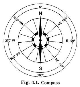
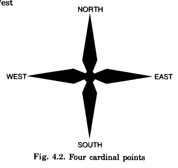
(b) Four cardinal directions:
(i) North
(ii) South
(iii) East
(iv) West
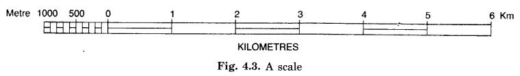
(c) The Scale of the Map:
Ratio between the distance on the paper and the distance on the ground is defined as the scale of the map.
Example: 1 cm = 5 kms.
- It means the distance on the paper between two points is 1 cm.
- The distance on the ground (actual distance) is 5 kms.
- 1 cm distance on the paper represents 5 km distance on the ground.
(d) Maps are more helpful than globe because of the following reasons:
- Globe cannot be used in all conditions.
- Globe can be used only when we want to study the whole Earth.
- It cannot be used when we want to study a village, road, building etc.
- Maps are used in the study of minutest items/features.
- It contains innumerable facts.
- Maps can be found in the form of an Atlas.
- Maps provide more information than Globe.
(e) Distinction between a map and a plan
| Map | Plan |
| 1. The map shows a large area on a sheet of paper such as-world, continents, countries, etc. | 1. It shows a small area on a sheet of paper such as a room, a garden, school building etc. |
| 2. The map is drawn on a small scale such as 1 centimetre = 1 kilometre etc. | 2. The plan is drawn on a large scale such as 1 centimetre = 1 metre. |
| 3. Colours arc mostly Used in maps. | 3. The plans are mostly simple. |
| 4. Only the important features can be shown in brief on a map. | 4. Even details of small and unimportant areas can be shown on a plan. |
(f) A thematic map provides detailed information.
(g) Symbols are an important part of a map. They give a lot of information in a limited space. With the use of symbols maps can be drawn easily and are simple to read. Even if we don’t know the language of an area and therefore cannot ask someone for directions. We can collect information from maps with the help of symbols.
Question 2.
Tick the correct answers.
(a) Maps showing distribution of forests are
(i) Physical map
(ii) Thematic map
(iii) Political map
(b) The blue colour is used for showing
(i) Waterbodies
(ii) Mountains
(iii) Plains
(c) A compass is used
(i) To show symbols
(ii) To find the main direction
(iii) To measure distance
(d) A scale is necessary
(i) For a map
(ii) For a sketch
(iii) For symbols.
Answer:
(a) → (ii) Thematic map
(b) → (i) Waterbodies
(c) → (ii) To find the main direction
(d) → (i) For a map.
INTEXT QUESTIONS
Question 1.
Find out the following directions from Figure 4.1 of your textbook
(a) the direction of the Community Centre, the playground from Vikas’s house,
(b) the direction of the school from shops. (NCERT Page 25)
Answer:
(a) Community Centre – North direction
Playground – North-East direction
(b) School – East
Question 2.
Look at the Figure 4.4 of your textbook and find out:
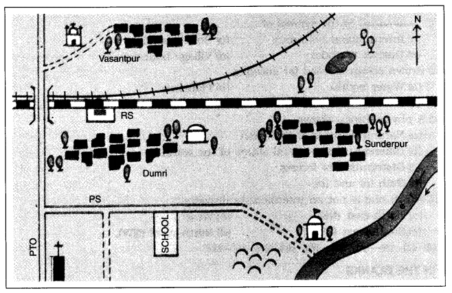
(i) In which direction is the river flowing?
(ii ) What kind of road passes by the side of village Dumri?
(iii) Sunderpur is situated on what type of railway line?
(iv) The police station is situated on which side of the railway bridge ?
(v) On which side of the railway line do the following lie: (NCERT Page 27)
(a) Chhatri
(b) Church
(c) Pond
(d) Mosque
(e) River
(f) Post and Telegraph Office
(g) Graveyard.
Answer:
(i) South-east portion.
(ii) Metalled Road.
(iii) Broad Gauge Railway Line.
(iv) South
(v) (a) South
(b) South-west
(c) North
(d) South
(e) South-east
(f) South-west
(g) South.
We hope the NCERT Solutions for Class 6 Social Science Geography Chapter 4 Maps, help you. If you have any query regarding NCERT Solutions for Class 6 Social Science Geography Chapter 4 Maps, drop a comment below and we will get back to you at the earliest.