Land Resources and Agriculture Class 12 Important Extra Questions Geography Chapter 5

Here we are providing Class 12 Geography Important Extra Questions and Answers Chapter 5 Land Resources and Agriculture. Geography Class 12 Important Questions are the best resource for students which helps in class 12 board exams.

Class 12 Geography Chapter 5 Important Extra Questions Land Resources and Agriculture

Land Resources and Agriculture Important Extra Questions Very Short Answer Type

Question 1.
How much part of total geographical area is cultivated ?
Answer:
43%.

Question 2.
What is the percentage of fallow land ?
Answer:
7.6%.

Question 3.
What is the average crop intensity in India ?
Answer:
130%.

Question 4.
What is total production of food grains in India ?
Answer:
2500 Lakh tonnes (2012).

Question 5.
What is the total production of Rice in India ?
Answer:
1020 Lakh tonnes (2012).

Question 6.
What is total production of Wheat in India ?
Answer:
840 Lakh tonnes (2012).

Question 7.
What is the total production of Tea in India ?
Answer:
10 Lakh tonnes.

Question 8.
How much percent of population depends on agriculture for its livelihood ?
Answer:
70 percent.

Question 9.
What is fallow land ?
Answer:
A land which is not cultivated for 1 to 5 years.

Question 10.
Which state has the highest intensity of crops ?
Answer:
Punjab, 189 percent.

Question 11.
State the formula to calculate cropping intensity. (C.B.S.E. 2009)
Answer:
\(=\frac{\text { Gross Cultivated Area }}{\text { Net Sown Area }} \times 100\)

Question 12.
Name the main cropping seasons of India.
Answer:
Kharif, Rabi and Zaid.

Question 13.
Name the three crops of Rice grown in one year.
Answer:
Aus, Aman and Boro.

Question 14.
Name the main types of Oil seeds grown in India.
Answer:
Groundnut, rapeseed, mustard, soyabean and sunflower.

Question 15.
How much area is irrigated in India ?
Answer:
570 lakh hectares.

Question 16.
Name the two most important cereal crops of India. Give the name of any two states which are the important producers of each of their crops.
Answer:
Wheat and Rice are the two most important cereal crops of India.

Important Producers
(a) Wheat: Uttar Pradesh and Punjab
(b) Rice: Uttar Pradesh and Punjab.

Question 17.
Explain any three features of dryland farming in India. (C.B.S.E. 2013)
Answer:
(i) Dryland farming is practised in areas with less than 75 ems rainfall.
(ii) This type of farming grows hard and resistant crops.
(iii) This practices method of soil moisture conservation.

Question 18.
Name the leading state in the production of Jute in India. (C.B.S.E. 2014)
Answer:
West Bengal.

Land Resources and Agriculture Important Extra Questions Short Answer Type

Question 1.
Distinguish between reporting area and geographical area.
Answer:
The land use categories add up to reporting area, which is some what different from the geographical area. The Survey of India is responsible for measuring geographical area of administrative units in India. The reporting area is calculated on land revenue records. The difference between the two concepts is that while the former changes somewhat depending on the estimates of the land revenue records, the latter does not change.

Question 2.
Distinguish between actual forest cover and classified forests.
Answer:
Actual forest cover is different from area classified as forest. The classified forest area is identified and demarcated by government for forest growth. But the actual forest cover is that area where forests are actually found.

Question 3.
State three facts to show the Agricultural development in India.
Answer:
Agriculture continues to be an important sector of Indian eocnomy,
(i) In 2001, about 53 per cent population of the country was dependent on it.

(ii) The importance of agricultural sector in India can be gauged from the fact that about 57 per cen t of its land is devoted to crop cultivation, whereas, in the world, the corresponding share is only about 12 per cent.

(iii) In spite of this, there is tremendous pressure on agricultural land in India, which is reflected from the fact that the land-human ratio in the country is only 0.31 ha. which is almost half of that of the world as a whole (0.59 ha.).

Question 4.
Define Agriculture. Which conditions favour agriculture ?
Answer:
Agriculture is the art and science of cultivating the land, raising crops for food. It includes tilling of land, raising of crops, and cattle rearing. The term agriculture has been derived from two Latin words: ager meaning ‘land’ and cultura meaning ‘cultivation’. Agriculture thus means cultivation of
land and tending of animals.

Favourable conditions for Agriculture : All lands are not suitable for cultivation.

Physical conditions : For crop raising land must be level, covered with fertile soils and have adequate rainfall and favourable temperature.

Human conditions : How man uses land also depends on the technology, tenure and size of the holdings, government policies and several other infrastructural factors.

Question 5.
What is the net sown area in India ? Where does India rank in world ?
Answer:
Land utilization statistics are available for 92.8 per cent of total geographical area (328.73 million hectares) of India. The net sown area is 140.3 million ha. in 2011-2012; it increased to 142.82 million ha. in 1996-97. Thus, about 46.59 per cent of the geographical area of the country is currently under cultivation as against only 36.1 per cent in 1950-51. About 23.2 million hectares are classified as fallow lands which constitute 7.6 per cent of the reported area.

Thus, India has more than half of the total area under cultivation. It is pertinent to note that India stands seventh in the world in terms of total geographical area but second in terms of cultivated land. The first being the LTnited States of America, which is two and a half times larger than India in land area.

Question 6.
Describe three main achievements of the Green Revolution in India.
Answer:
(i) It has led to a substantial increase in production and productivity of foodgrains increasing from 72 million tonnes (1965-66) to 210 million tonnes (2003-04).
(ii) Import of foodgrains declined from 10.3 million tonnes (1965-66) to 2.4 million tonnes in 1983-84. There was no import of food grains in 2000-01.
(iii) The croppd area, use of high yielding varities, the yield per hectare use of irrigation and fertilisers has increased.

Question 7.
Why is agricultural productivity still low in India ? Write three main reasons.
Answer:
In India, the yield per hectare of foodgrains and other crops is low. The main reasons lare:
(i) Less use of HYV. Only 16% of the cultivated land is under HYV.
(ii) Poor technique. The fertility of soils is declining. Use of fertilisers and pesticides is limited.
(iii) Low investment. Poor farmers cannot invest in agriculture. Size of farms is small.

Question 8.
Describe any three haraeteristies of wetland farming in India. (2013)
Answer:
(i) In wetland farming, rainfall is more than 75 cms.
(ii) These grow various water intensive crops such as Rice, Jute, etc.
(iii) Rainfall is in excess of soil moisture requirements of plants.

Question 9.
Classify land according to its ownership. State the characteristics of common property sources. Why are common property resource called natural resources ?
Answer:
Land, according to its ownership can broadly be classified under two broad heads—
(i) private land and
(ii) common property resources (CPRs). While the former is owned by an individual or a group of individuals, the latter is owned by the state meant for the use of the community. CPRs provide fodder for the livestock and fuel for the households along with other minor forest products like fruits, nuts, fibre, medicinal plants, etc.

In rural areas, such land is of particular relevance for the livelihood of the landless and marginal farmers and other weaker sections since many of them depend on income from their livestock due to the fact that they have limited access to land. CPRs also are important for women as most of the fodder and fuel collection is done by them in rural areas. They have to devote long hours in collecting fuel and fodder from a degraded area of CPR.

Natural Resources. CPRs can be defined as community’s natural resource, where every member has the right of access and usage with specified obligations, without anybody having property rights over them. Community forests, pasture lands, village water bodies and other public spaces where a group larger than a household or family unit exercises rights of use and carries responsibility of management are examples of CPRs.

Question 10.
What is the importance of land resources ? State three facts.
Answer:
Land resource is more crucial to the livelihood of the people depending on agriculture :
(i) Agriculture is a purely land based activity unlike secondary and tertiary activities. In other words, contribution of land in agricultural output is more compared to its contribution in the outputs in the other sectors. Thus, lack of access to land is directly correlated with incidence of poverty in rural areas.

(ii) Quality of land has a direct bearing on the productivity of agriculture, which is not true for other activities.

(iii) In rural areas, aside from its value as a productive factor, land ownership has a social value and serves as a security for credit, natural hazards or life contingencies, and also adds to the social status.

Question 11.
‘Scope for bringing in additional land under net sown area in India is limited.’ Discuss. How can we increase cultivated land ?
Answer:
It may be observed that over the years, there has been a marginal decline in the available total stock of cultivable land as a percentage to total reporting area. There has been a greater decline of cultivated land, in spite of a corresponding decline of cultivable wasteland. It is clear that the scope for bringing in additional land under net sown area in India is limited.

There is, thus an urgent need to evolve and adopt land-saving technologies. Such technologies can be classified under two heads—those which raise the yield of any particular crop per unit area of land and those which increase the total output per unit area of land from all crops grown over one agricultural year by increasing land-use intensity.

The advantage of the latter kind of technology is that along with increasing output from limited land, it also increases the demand for labour significantly. For a land scarce but labour abundant country like India, a high cropping intensity is desirable not only for fuller utilisation of land resource, but also for reducing unemployment in the rural economy.

Question 12.
Describe the different cropping seasons in India. Name the crops grown in each season. (C.B.S.E. 2014)
Answer:
Cropping Seasons in India
There are three distinct crop seasons in the northern and interior parts of country, namely kharif, rabi and zaid.
(1) The kharif season largely coincides with Southwest Monsoon under which the cultivation of tropical crops such as rice, cotton, jute, jowar, bajra and tur is possible.

(2) The rabi season begins with the onset of winter in October-November and ends in March-April. The low temperature conditions during this season facilitate the cultivation of temperate and subtropical crops such as wheat, gram and mustard.

(3) Zaid is a short duration summer cropping season beginning after harvesting of rabi crops. The cultivation of watermelons, cucumbers, vegetables and fodder crops during this season is done on irrigated lands.

Question 13.
Distinguish between wetland farming and dryland farming.
Answer:
Rainfed farming is further classified on the basis of adequacy of soil moisture during cropping season into dryland and wetland farming. In India, the dryland farming is largely confined to the regions having annual rainfall less than 75 cm. These regions grow hardy and drought resistant crops such as ragi, bajra, moong, gram and guar (fodder crops) and practise various measures of soil moisture conservation and rain water harvesting.

In wetland farming, the rainfall is in excess of soil moisture requirement of plants during rainy season. Such regions may face flood and soil erosion hazards. These areas grow various water intensive crops such as rice, jute and sugarcane and practise aquaculture in the fresh water bodies.

Question 14.
Distinguish between Protective irrigated farming and Productive irrigated farming.
Or
Distinguish between Protective Irrigation and Productive Irrigation. (Outside Delhi 2019)
Answer:
On the basis of main source of moisture for crops, the farming can be classified as irrigated and rainfed (barani). There is difference in the nature of irrigated farming as well based on objective of irrigation, i.e. protective or productive. The objective of protective irrigation is to protect the crops from adverse effects of soil moisture deficiency which often means that irrigation acts as a supplementary source of water over and above the rainfall.

The strategy of this kind of irrigation is to provide soil moisture to maximum possible area. Productive irrigation is meant to provide sufficient soil moisture in the cropping season to achieve high productivity. In such irrigation the water input per unit area of cultivated land is higher than protective irrigation.

Question 15.
Name the major oil seeds grown in India. Also state the major areas of production.
Answer:
The oilseeds are produced for extracting edible oils. Drylands of Malwa plateau, Marathwada, Gujarat, Rajasthan, Telangana and Rayalseema region of Andhra Pradesh and Karnataka plateau are oilseeds growing regions of India. These crops together occupy about 14 per cent of total cropped area in the country. Groundnut, rapeseed and mustard, soyabean and sunflower are the main oilseed crops grown in India.

Question 16.
(i) What is intensity of cropping ?
(ii) Explain four factors affecting it.
(iii) Give two reasons for high index of intensity of cropping in Punjab.
Answer:
Intensity of cropping means the number of crops raised on the same field in one agricultural year. If two crops are grown in a year, the index of cropping is 200. It shows intensive use of the land. Intensity of cropping is influenced by the following factors:

  • Irrigation facilities
  • Use of fertilisers
  • Use of high yielding varieties
  • Mechanisation
  • Use of pesticides.

The intensity of cropping in Punjab is due to high inputs. There is heavy application of fertilisers. A large area is under irrigation and mechanised farming. High yielding varieties are grown.

Question 17.
Distinguish between crop rotation, crop intensity and mixed cropping.
Answer:
Crop rotation means the cultivation of different crops in the same field year after year. The change of crops helps to maintain the fertility of the fields. Crop intensity means the number of crops grown on the same field in the agricultural year. Mixed cropping refers to the practice of sowing two to three crops together in the same field in one crop season.

Question 18.
What does the term dry farming mean ?
Answer:
Dry farming is an agricultural method practised in areas where rainfall is scanty (less than 50 cms). In such regions, irrigation facilities are also not available. In this method, deep ploughing is done after every rain to preserve most of the rain water. In such areas, one crop is grown in a year. Generally, drought resisting crops like wheat, cotton, gram and pulses are grown. In India, dry farming is practised in arid areas of Rajasthan, Gujarat and Haryana.

Question 19.
What do you mean by fallow land ? How can we reduce the period of fallowing ?
Answer:
Continuous cropping in the same field for a long period results in the depletion of soil-nutrients. In order to provide time for the recoupment of the soil fertility, land is kept without crop for a season or a year. The soil fertility increases through this natural process. When land is left without crop for a season it is called current fallow land. It is called old fallow land if it is left without crop for a period of more than one year. The extent of fallowing may be reduced by higher dose of fertilizer and manure.

Question 20.
Which are the two important staple food crops of India ? Give three points of contrast in the climatic and soil requirements of the two crops named by you.
Answer:
Wheat and rice are the two staple crops. Wheat needs cool wet growing season and warm dry harvesting season, but rice needs high temperature throughout. Wheat needs moderate rainfall. Rice needs high rainfall. Loamy soils are best suited for wheat, while rice is grown on alluvial soils.

Question 21.
Describe lancUuse pattern in ndia. C.B.S.E. 2011)
Answer:
Land-use pattern. Land is a limited resource. Attempts are made to make the maximum use of land. India has a total geographical area of 32.8 crore hectares. Main characteristics of land-use are as under:
(a) Net Sown area. About 54% of total land (7.6 crore hectares) is net sown area. This vast area shows the importance of agriculture in India.

(b) Fallow land. About 7% land (2.4 crore hectares) is left as fallow land and is cultivated after two or three years.

(c) Forests. About 23% of land is (6.6 crore hectares) under forests.

(d) Plantation crops. About 1% land is under plantation crops like tea, coffee, etc.

(e) Other uses. Land under permanent grassland, cultivable waste and not available for cultivation amounts to about 5 crore hectares. Area under forests is increasing. Fallow land has been reduced in area. Net sown area under doubled cropped area is also increasing.

Question 22.
What is crop rotation ? Why has this method been adopted ?
Answer:
When the different crops are sown turn by turn in the same field; it is called crop rotation. For example: Pulses, Legumes and Oilseeds are grown in the same field after harvesting food crops. This is helpful in correcting the imbalance of the soil nutrients.

Same crop year after year accelerates the loss of soil nutrients. Legumes have the utility of fixing nitrogen of the soil from atmosphere. Oilseeds also fix nitrogen. Highly fertilizer intensive crops like sugarcane or tobacco are rotated with cereal crops. Selection of the crops for rotation depends upon the local soil conditions and the experience of the farmers.

Question 23.
Explain the importance of agriculture in Indian economy.
Answer:
India is an agricultural country. Agriculture is not only the backbone of Indian economy, but also a way of living in India. Agriculture provides work to about 70 per cent of the total work force of the country. It contributes 35 per cent of the net national product. It provides food for hillions of people of the country. About 20 crore herds of cattle get fodder.

Agriculture provides raw materials to agro-based industries like cotton textiles, sugarcane, etc. It also contributes a sizeable share of the country, total exports—by earning a foreign exchange of about ? 5000 crores which accounts for about 70% on total exports. Agriculture provides base for development of other sectors. It ensures higher purchasing power in rural areas. It generates demand for industrial goods.

Question 24.
How did Green Revolution bring about ‘grain revolution’ in some parts of India ?
Answer:
Since the 1960s, a new strategy has been used for the intensive agricultural development in India. It has led to a rapid increase in the production of foodgrains in the country. A revolution has taken place in the agricultural methods and technology. This revolution is known as Green Revolution. It includes the use of better quality seeds, high yielding varieties, chemical fertilisers, agricultural machinery and to provide irrigation facilities. It has led to a complete modernisation of Indian agriculture.

This strategy was introduced to do away with food shortage and import of foodgrains. In 1965, the total production of foodgrains was 90 million tonnes. It became essential to increase the cropped area total production and yield per hectare. Wonderful results were achieved through Green Revolution. The total production of foodgrains in 2015-2016 has increased to above 280 million tonnes. In fact, Green Revolution has been a grain revolution.

It is clear from the following table :

Year Foodgrains production (Million tonnes)
1970 – 71 108.4
1980 – 81 129.6
1990 – 91 176.4
2000 – 01 196.8
2006 – 07 217.3
2009 – 10 218.1
2015 – 16 280.0

The adoption of Green Revolution has given a boost to agricultural development in many aspects such as:
(i) The chopped area has increased due to multiple cropping.

(ii) The use of high yielding varieties of wheat and rice like Kalyan, S-308, Jaya, Ratna, etc. have led to increased yields per hectare. The yield of wheat rose from 13 quintal per hectare to 33 quintals per hectare in Punjab. In case of rice, a 45% increase in productivity was obtained in Andhra Pradesh.

(iii) The use of extensive irrigation increased the total production of foodgrains.

(iv) Use of chemical fertilisers led to higher yield per hectare.

(v) Massive programme of farm mechanisation, use of better quality seeds and pesticides, use of agricultural implements has led to the success of Green Revolution.

Question 25.
Review any five measures adopted to solve the problems of Indian agriculture.
Answer:
Agriculture is a very important sector of Indian economy. In spite of the phenomenal progress particularly since the 1960s, Indian agriculture still suffers from several serious problems, such as :

(1) Dependence on Erratic Monsoon : Unfortunately, most parts of the India receive rainfall in 3 – 4 months of the rainy season and rest of the year is practically dry, large (parts) of the country do not receive sufficient amount of rainfall. Such areas can give high agricultural productivity if sufficient arrangements for irrigation and water harvesting are made.

(2) Low Productivity : Yields of almost all the crops in India is very low. High pressure of population results in low labour productivity. We have to use HYV seeds and fertilizes to increase the productivity.

(3) Small Farm Size: Small land holdings is major obstacle in the way of modernisation of agriculture. These are some states where consolidation of holding has not yet been carried out even once.

(4) Lack of Commercialisation : Indian agriculture is still of subsistence type. Foodgrains produced by small and marginal farmers are just sufficient to meet the requirement of the family members of the farmers. Irrigation and modern farm techniques has spread to the country at a rapid pace.

(5) Lack of development of rural infrastructure, withdrawal of subsidies and price support and crop rotation etc., reduce the regional imbalances if these implement properly.

Land Resources and Agriculture Important Extra Questions Long Answer Type

Question 1.
Discuss the geographical conditions favouring the cultivation of wheat. Describe production and areas of cultivation in India.
Answer:
Wheat is one of the master grains of the world. It is the ‘staple food’ for 1/3 people of the world. It is a valuable cereal due to high gluten content. It has been grown since pre-historic times. It was originally grown in Mediterranean lands.

Conditions of Growth. Wheat is a plant of temperate latitudes. It is grown in a variety of climates. The cultivation of wheat is widespread in the world. Every month, wheat is being seeded or being harvested in some part of the world.

(i) Temperature. Wheat requires a minimum temperature of 10°C in the growing period and a maximum temperature of 20°C in the harvesting period. A frost-free period of 100 days is required for wheat.

(ii) Rainfall. The wheat lands generally need a moderate rainfall between 50 to 100 cms. annually. Wheat needs a cool and wet growing season, but a warm and a dry harvesting season.

(iii) Irrigation. Means of irrigation are used in areas of low rainfall as in Indus and Punjab. Dry farming methods are also used.

(iv) Soil. Light clay or heavy loamy soil is the best soil for wheat.

(v) Land. Wheat needs well-drained level land. It suits the use of machinery and means of irrigation.

(vi) Economic Factors: Wheat is a soil exhausting crop. Better seeds, chemical fertilisers and new varieties are used to increase the yield per hectare. It is a mechanised agriculture.Machines like tractors, combines, harvesters are often used. Huge stores are required to store wheat.

Production in India: India ranks as the second largest producer of wheat in the world (12% production). Wheat is a winter crop and India produces about 67 million metric tons of wheat. India has become self-sufficient in wheat production due to Green Revolution, yield per hectare is 2618 kg.

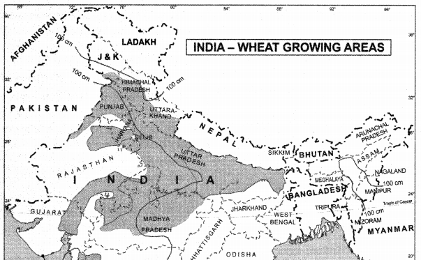
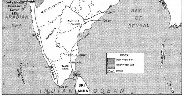
Area of cultivation: Wheat is grown in most of the Sutlej-Ganga plain (N.W. India). Spring wheat is grown in hilly areas of Lahaul-Spiti (Himachal Pradesh), Ladakh, Sikkim in the Sub-Himalayan region, upto a height of 2700 metres. Wheat is grown on 14% of Net Sown area. Uttar Pradesh, Punjab, Haryana, Madhya Pradesh and Rajasthan are the main wheat producing areas. These regions have the favourable conditions of fertile soils, winter rain, irrigation facilities.
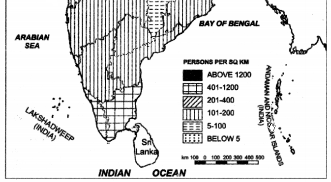
Geography Class 12 Important Questions Chapter 5 Land Resources and Agriculture 1
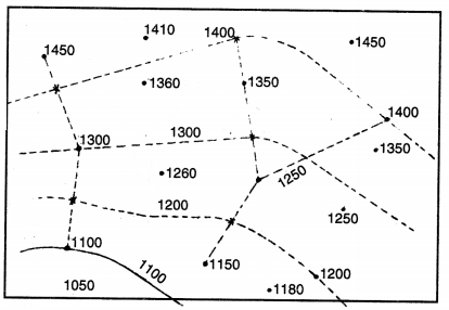
Geography Class 12 Important Questions Chapter 5 Land Resources and Agriculture 2

Question 2.
Describe the conditions of growth, production and major area of cultivation of rice in India.
Answer:
Rice had been cultivated since pre-historic times. China and India are regarded as the birthplace of rice. Rice is the staple food of millions of people in monsoon Asia. Rice is also called ‘Gift of Asia’.

Types of rice:
There are many varieties of rice but rice is broadly divided into two types
(i) Upland Rice. This rice is grown in hilly areas and has low yields.
(ii) Lowland Rice. This rice is grown on the lowland areas of river valleys and deltas and has high yields.

Methods of cultivation:
Rice is sown by three methods:
(i) Drilling method
(ii) Broadcasting method.
(iii) Transplanting method.

Conditions of growth:
Rice is a crop of hot-wetland of the tropics. Rice cultivation is concentrated in Monsoon Asia.
(i) Temperature. Rice needs a temperature of 20°C during the growing season and a temperature of 27°C during the harvesting period. Due to uniformly high temperature, 3 crops of rice a year are produced in West Bengal.

(ii) Rainfall. Rice is a plant of wet areas with an annual rainfall between 100 to 200 cms. Rice is grown in flooded fields. Irrigation is used in areas of low rainfall as in Punjab.

(iii) Land. Rice needs level land so that the fields can be flooded. Rice is grown on hilly slopes with Terraced Agriculture upto a height of 2000 metres.

(iv) Soils. Heavy clay or loamy soil is the ideal soil for rice. River valleys, delta and coastal plains are most suited for rice cultivation.

(v) Cheap Labour. Rice needs large supply of cheap human labour. It is labour intensive crop because most of the work in the fields is done by hand. It is also called ‘Hoe-culture’. The densely populated areas supply cheap plentiful labour.

In brief we can say ‘Rice needs plenty of heat, plenty of water, plenty of alluvium, plenty of labour to produce plenty of rice for plenty of people. ’

India. India is the second largest producer of rice in the world. About 24% (22%) of the (40 million hect.) cultivated land is under rice. India produces about 86 million metric tons of rice. Over large areas, only one crop of rice is grown every year. The yield per hectare is not high. High-yielding varieties are being used to increase the production. Yield per hectare is 1562 kg.

West Bengal is the largest producer of rice in India. Due to hot and wet climate, 3 crops are grown on the same land in a year. Aman, Aus and Boro are the three types of rice crops. Rice is grown throughout the Sutlej-Ganges plain in Punjab, Haryana (with irrigation), Uttar Pradesh and Bihar and coastal plains.

Question 3.
Describe the conditions of growth, production, areas of cultivation of cotton in India.
Answer:
Cotton is the leading fibre crop of the world. Of all the fibres, cotton is produced in the largest quantity. It is known from the writing of Herodotus that cotton has been in use in India since 3000 BCE. It is a universal fibre. Now-a-days many synthetic fibres are being used, but the cheapness and lightness of cotton make it an ideal fibre for clothing.

Conditions of Growth. Cotton is a plant of tropical and subtropical areas.
(i) Temperature. Cotton needs uniformly high summer temperatures between 22°C to 32°C. It requires a warm climate with bright sunshine. Frost is harmful to cotton plant. A growing period of 210 frost free days is necessary. It is grown as an annual crop. Sea breezes increase the lustre and length of the cotton fibre.

(ii) Rainfall. Cotton needs light to moderate rainfall between 50 to 100 cms. It needs light showers during the growing period and a dry sunny picking period.

(iii) Irrigation. In arid areas, irrigation is used. It increases the yield per hectare as in Punjab.

(iv) Soils. Cotton grows best on rich,well-drained loamy soils. Lava soil is capable of retaining moisture and is highly suitable for the cultivation of cotton. Regular use of fertilisers is required to maintain the fertility of the soil.

(v) Cheap Labour. Cotton is picked by hand. Generally women labour is used. The presence of large, cheap and hard-working labour is necessary.

(vi) Land. Cotton is grown best on flat, or rolling lands. These are well-drained areas. Machinery can be used in such areas.

(vii) Absence of Diseases. The control of pests and diseases is necessary.
India. India is the fourth largest producer (8.3%) of cotton in the world. India has the largest acreage under cotton cultivation. India is the oldest cotton- producing country in the world. The Cotton Textile Industry depends on Indian cotton. India has low yield of cotton.

Mostly short staple cotton is produced. Long staple cotton is imported from Egypt, Sudan and Pakistan. About 65 lakh hectare area (4.7% area) is under cotton cultivation. The total production is 20 lakh tonnes.

Areas of Cultivation. Due to a great diversity in climate and soil the cotton producing areas are found scattered over India. Southern India produces more cotton than Northern India.

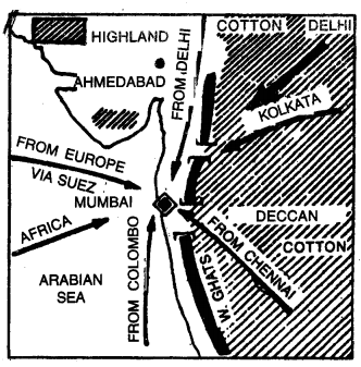
(i) Black Cotton Soil Region. This is chief cotton growing area of India on the lava soils of North-West Deccan. Gujarat, Maharashtra and Madhya Pradesh are the major cotton-producing states.

(ii) Red Soil Region. Medium staple cotton is grown in the red soil area including the states of Tamilnadu, Karnataka and Andhra Pradesh.

(iii) Alluvial Soil Region. Long staple cotton (Narma) is grown on the Alluvial soils of Northern plain. The states of Punjab, Haryana and Rajasthan are the important producers of cotton. Punjab has the highest yield per hectare due to wrarm climate, fertile soil and facilities of irrigation.

Question 4.
Describe the geographical conditions required for the cultivation of Tea. Describe its production and distribution in India.
Answer:
Tea is the most popular and stimulating drink in the world. Assam (India) and China are the native places of tea. Tea plantations were started by the Europeans. Tea is made from the leaves of a tropical bush. It contains a stimulating substance called Theme’or ‘Tannic acid.’

Types of Tea. Different varieties of Tea fall into four main types:

  • Black Tea.
  • Green Tea.
  • Brick Tea.
  • Oolong Tea.

Conditions of Growth. Tea is a plant of both tropical and temperate areas.
(i) Temperature. Tea requires uniformly high temperature (20°C – 30°C) throughout the year. More pickings can be done due to warm summers. Frost is harmful for tea leaves.

(ii) Rainfall. An annual rainfall of 150 cms. is essential for the growth of tea. Rainfall should be uniform and in frequent showers. Long-dry season is harmful for tea. Shady trees protect tea-bushes from strong sunlight. Irrigation is also used.

(iii) Soil. Tea requires a deep and fertile soil. Soil should be acidic to give better flavour. A content of iron and potash is helpful.

(iv) Land. Tea is grown on gently sloping, well- drained hilly slopes and valley-sides. Tea plantations are most suited upto a height of 300 metres above sea level.

(v) Labour. Tea is a labour intensive crop. It requires a cheap, skilled labour for picking tea leaves. Picking is done by hand. Mostly women labour is used for picking.

(vi) Management. A successful tea plantation requires a good management and huge capital.

(vii) Weather. Heavy fog, high humidity and morning dew favour the growth of tea leaves.

Major Producing Areas:

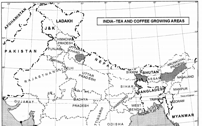
India. Tea is a commercial crop in India. India is the largest producer of Tea (28%) of the world. India is the third largest exporter of tea in the world, earning a foreign exchange of ? 1100 crores. There are about 12000 tea estates managed by 700 tea companies. The total production is 81 crore kg.
Areas of Cultivation. More tea is produced in Northern India than Southern India.

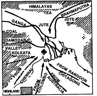
(a) Assam. Assam is the largest producer of tea in India. Tea is grown on the valley-sides of Brahmputra and in Duar region. Hot-Wet Monsoon climate, cheap labour, fertile land and good management are favourable factors.

(b) West Bengal. Tea is grown in Darjeeling and Jalpaiguri districts in West Bengal. Darjeeling tea has a special flavour. This flavour is due to slow growth under high humidity and low temperature due to high altitude.

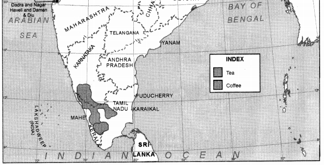
(c) Southern India. Tea is grown on the slopes of Nilgiris, Cardamom and Anamalai hills. Coimbatore (Tamil Nadu), Malabar coast (Kerala), Coorg region (Karnataka) and Ratnagiri (Maharashtra) are important areas of tea production.

(d) Other Areas.

  • Ranchi Plateau in Jharkhand.
  • Palampur in Himachal Pradesh.
  • Kumaon and Garhwal hills in Uttarakhand.
  • Tripura Region.

Question 5.
Describe the conditions of growth, production and distribution of coffee in India.
Answer:
Coffee. Coffee is a plantation crop. It is a powder obtained from the seeds of berries of a tree. It contains a stimulating substance called “Caffeine”. Next to tea, coffee is the most popular drink in the world. It is prized for its flavour. Conditions of Growth. Coffee is a plant of tropical and sub-tropical regions.

(i) Temperature. Coffee requires uniformly high temperature (22 °C), throughout the year. Strong winds and frost are harmful. Therefore, coffee is planted on the protected hill slopes.

(ii) Rainfall. Coffee needs an annual rainfall of 100 to 150 cms. Coffee needs a hot-wet growing season, but a cool dry harvesting season. Irrigation is also used in dry season.

(iii) Shady Trees. Coffee can’t stand direct sunshine. Therefore coffee trees are planted under shady trees such as bananas.

(iv) Soils. Coffee needs deep, fertile soil. It should contain iron, potash and organic content. Lava soils and deep loams are suitable.

(v) Land. Coffee grows best on well-drained hill slopes. Most of coffee is grown at height up to 1000 metres.

(vi) Cheap Labour. Coffee has to be hand picked. Therefore a large, cheap labour is required. The transplanting, pruning, harvesting and processing of coffee need a large supply of human labour.

(vii) Absence of disease. Most of the coffee plantations have been destroyed due to insects like beetle. So plant protection from diseases is necessary.

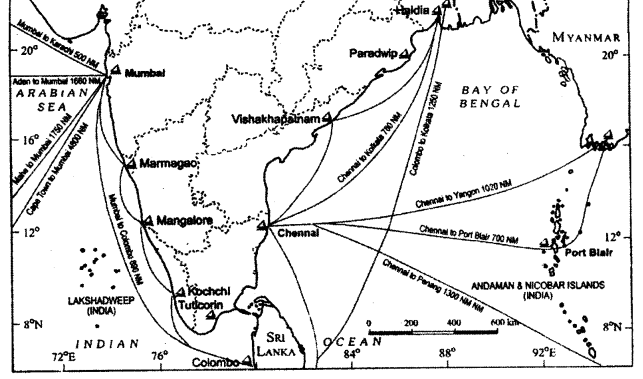
India. Coffee was introduced by a Muslim faqir named Baba Boodan’. Coffee plantations were started in 1830 in Chick-mangloor district (Karnataka). India produces about two lakh tonne coffee on the area of 2 lakh hectares. About 60% of the total production is exported through the ports of Kozhi-Kode, Chennai
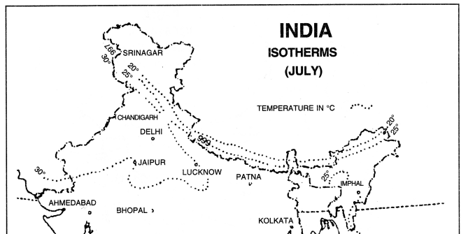
Geography Class 12 Important Questions Chapter 5 Land Resources and Agriculture 3
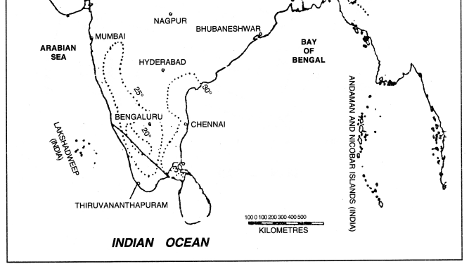
Geography Class 12 Important Questions Chapter 5 Land Resources and Agriculture 4

and Mangaluru. India earns a foreign exchange of about ₹ 1500 crores by this export.

Areas of Cultivation: Cool climate doesn’t encourage coffee cultivation in Northern India. Coffee is mostly grown in the hills and plateaus of Southern India in Shimoga, Kadoor, Hassan and Coorg districts (Nilgiris in Karnataka).

Question 6.
Analyse the geographical conditions required for the cultivation of Sugarcane. Describe the major producing areas of Sugarcane in India.
Answer:
Sugar is an important item in man’s food. Sugar is most widely liked and used in the world. This luxury item has a universal demand. The two main sources of sugar are sugarcane and sugar beet. About 5% sugar of the world is obtained from sugarcane. It is a commercial and industrial crop. Many products like Gur, Molasses, Paper, Wax and Fertilizers are prepared from sugarcane. India is considered the native place of sugarcane.

Conditions of Growth. Sugarcane is a plant of hot and wet tropical region.
(i) Temperature. High temperatures between 21°C and 27°C are required throughout the year. It is grown in a long sunny growing season. Frost and cloudiness are harmful for sugarcane.

(ii) Rainfall. A rainfall of 100 to 175 cms. is required. The harvesting period should be dry. Sugarcane is grown under irrigation in dry areas.

(iii) Soils. Sugarcane is grown well on deep, fertile soils which can retain moisture. Alluvial soils, volcanic soils and calcareous (Limestone) soils are best suited for the growth of sugarcane.
Geography Class 12 Important Questions Chapter 5 Land Resources and Agriculture 5
Geography Class 12 Important Questions Chapter 5 Land Resources and Agriculture 6

(iv) Cheap Labour. Large supply of cheap labour is required mainly at the harvest time.

(v) Land. Sugarcane is cultivated on level, well- drained low lands. Such areas provide easy transportation, irrigation and use of machines.

(vi) Sea-Breezes. In coastal areas, sea breezes are useful. These increase the sugar content.

(vii) Use of fertilisers. Soils are kept fertile with the use of fertilisers. It gives high yields.

Major Sugarcane Producing Areas:

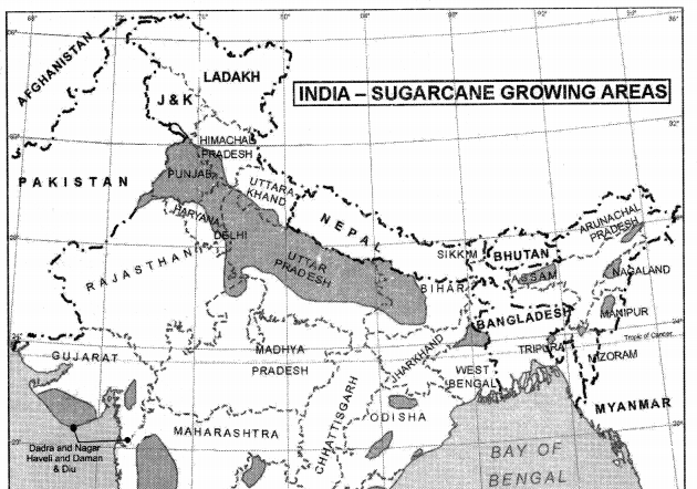
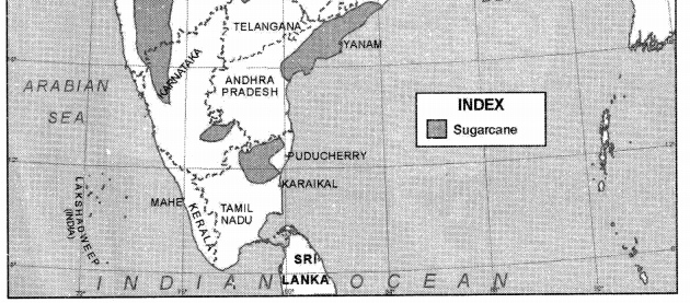
India. India is the second largest and the oldest sugarcane producer (23%) in the world. India has the largest acreage (33%) under sugarcane in the world. But the yield is low. In India, favourable conditions are found in Southern India. This region with hot- wet climate gives better yield. About 60% of sugarcane  is produced in Northern plain due to fertile soils. India produces about 2900 lakh metric ton sugarcane on an area of 33 lakh hectares.

Areas of Cultivation: The sugar belt of India extends from Gurdaspur (Punjab) to Darbhanga (Bihar), Uttar Pradesh with a production of 88 lakh tonnes, is the largest producer of sugarcane in India. It is grown in Doab, Terai and Gorakhpur region. Andhra Pradesh, Tamil Nadu, Maharashtra, Punjab and Bihar are other main producers of sugarcane.

Question 7.
Describe the conditions of growth, production and distribution of Millets in India.
Answer:
Millets
(i) Jowar. Jowar ranks third in area among foodgrains. Jowar can be grown in semi-arid and arid having rainfall under 45 cms. High temperature is necessary for its growth. It is generally grown on poor soils and in precarious rainfall zones. Jowar is both kharif and rabi crop. About 7.0 million hectares (5.3%) are devoted to this crop in India. Thanks to the hybrid seeds, its production increased.

Jowar is grown throughout the peninsular India but its notable concentration is on heavy or medium black soils and in regions with annual rainfall under 100 cms. Half (50.1%) of the jowar cropped area of the country is in Maharashtra. Karnataka (21.2%), Andhra Pradesh, Tamil Nadu and Madhya Pradesh are also major jowar producers.

(ii) Bajra. Bajra, an inferior millet crop, is grown on lighter soils and drier conditions than jowar, and therefore, does well on well-drained sandy, loamy soils and shallow black soils. Marusthali and Aravalli hills of Rajasthan, south-western Haryana, Chambal basin, south-western Uttar Pradesh; Kachchh, Kathiawar and northern Gujarat, and rain shadow area of Western Ghats of Maharashtra are important areas of bajra cultivation. It is also a rainfed kharif crop.

Bajra occupies 7.6 million hectares (about 5.0%) of cropped area of the country. Its production increased to 4.6 million tonnes. Rajasthan, is the largest bajra producing state in the country. Uttar Pradesh Maharashtra, Gujarat, and Haryana are other important producers of bajra.

(iii) Maize. Maize occupies 3.6 per cent of the cropped area of the country. Its production was 10.3 million tonnes. Both the area and production have increased rapidly. Use of yield raising hybrid strains, fertilisers, and irrigation helped in enhancing productivity. Production of maize has increased ten times between 1951 and 2001.

Maize is cultivated throughout the country. Karnataka ranks first in production, followed by Uttar Pradesh, Bihar and Andhra Pradesh. Madhya Pradesh, Rajasthan, Gujarat, and Himachal Pradesh are other producers.

(iv) Pulses. Pulses are the main source of protein in Indian diet. They are leguminous crops and enhance soil fertility by fixing. Nitrogen Pulses need less moisture and survive even in dry conditions. Tur (pigeonpea), urd (black gram), moong (green gram), and moth (brown gram) are major kharif crops and gram, peas, tur, masoor (lentil) and urd are rabi crops. Their production rose from 8.4 million tonnes to 11.4 million tonnes.

(v) Gram is the principal pulse crop in the country. The major gram growing areas are the Malwa plateau of Madhya Pradesh, north-eastern Rajasthan and southern Uttar Pradesh. Madhya Pradesh produces more than two-fifths (40.8%) of the total gram output in the country, Uttar Pradesh is next to it (19.6%).

Tur is another important pulse crop. Major tur producers are Maharashtra and Uttar Pradesh. The distribution of other pulse crops varies widely. Uttar Pradesh produced 2.2 million tonnes (20.3%) of pulses, and thus was the largest producer of pulses in the country. Madhya Pradesh (19.5%), and Maharashtra (15.3%) are other major pulse producing states.

Question 8.
What is Green Revolution ? What are its effects ?
Answer:
Green Revolution. Since the 1960s a new strategy has beer used for the intensive agricultural development in India. It has led to a rapid increase in the production of foodgrains in the country. A revolution has taken place in the agricultural methods and technology.

This revolution is known as Green Revolution. It includes the use of better quality seeds, high yielding varieties, chemical fertilisers, agricultural machinery, and to provide irrigation facilities. It has led to a complete modernisation of Indian agriculture.

This strategy was introduced to do away with food shortage and import of foodgrains. In 1965, the total production of foodgrains was 90 million tonnes. It became essential to increase the cropped area total production and yield per hectare. Wonderful results were achieved through Green Revolution. The total production of foodgrains in 2005-2006 has increased to above 230 million tonnes. In fact, Green Revolution has been a grain revolution.

It is clear from the following table :

Year Foodgrains production (Million tonnes)
1966—67 74
1970—71 107
1977—78 110
1980—81 111
1984—35 150
1989—90 175
2005—06 230
2015—16 280

The adoption of Green Revolution has given a boost to agricultural development in many aspects such as— (i) The cropped area has increased due to multiple cropping.

(ii) The use of high yielding varieties of wheat and rice like Kalyan, Sonalika, Jaya, Ratna, etc. has led to increased yields per hectare. The yield of wheat rose from 13 quintal per hectare to 33 quintal per hectare in Punjab. In case of rice, a 45% increase in productivity was obtained in Andhra Pradesh.

(iii) The use of extensive irrigation increased the total production of foodgrains.

(iv) Use of chemical fertilisers led to higher yield per hectare.

(v) Massive programme of farm mechanisation, use of better quality seeds, and pesticides, use of agricultural implements has led to the success of Green Revolution.

Social effects: The standard of living of farmers has risen due to increase in per capita income. Tractor is a common asset in Punjab. Literacy has risen among the farmers. Recreation facilities are increasing due to Green Revolution.

It has not been possible to apply Green Revolution all over the country. Due to inadequate facilities of irrigation, fertilisers, lack of capital to purchase machinery, uneconomic size of land holdings, the sm all farmers could not take the advantage of Green Revolution.

Question 9.
‘Inspite of significant I development, Indian Agriculture suffers from some problems? Explain. (C.B.S.E. 2011, 2014)
Or
“Erratic monsoons and indebtness” are the major problems of Indians for agricultureSuggest and explain the measures to overcome these problems.
Or
Describe the major challenges of I agriculture in present india. (Sample Paper 2017-18)
Or
“Lack of Land reforms and degradation I of cultivable land are the major problems of Indian agriculture.” Substantiate the ; statement. (.Delhi 2019)
Or
“Erratic monsoon and low productivity are the major problems of Indian ; agriculture.” Substantiate the ; statement. (Delhi 2019)
Answer:
Problems of Indian Agriculture. Though Herculean efforts are being made for agricultural development, productivity of crops, however, is still low in comparison to the developed countries of the world. This situation is the result of the interplay of several factors. These are grouped into four classes: (i) environmental
(ii) economic
(iii) institutional, and
(iv) technological.

(i) Environmental Factors. The most serious problem is the erratic nature of the monsoon. Temperature remains high throughout the year. Therefore, crops can be grown all the year round if sufficient water could be supplied regularly. But it is not possible because major portion of the country receives rainfall during 3-4 months and rainfall amount and its seasonal and regional distribution are highly variable.

This situation affects the agricultural development. Major part of the country is sub-humid, sub-arid and arid as far as amount of rainfall is concerned. These regions suffer from frequent occurrences of droughts. Development of irrigation and water harvesting can raise productivity of these regions.

(ii) Economic factors. Investment in agriculture, use of inputs such as HYV, fertilisers etc. and transport facilities constitute economic factors. On account of lack of marketing facilities or non availability of loan on fair rate of interest, the cultivators are not able to invest the requisite resources in agriculture. This results in low productivity. In fact the pressure of population on land is continuously increasing. Consequently, per capita cropped land has declined from 0.444 hectare in 1921 to 0.296 hectare in 1961 and 0,219 hectare in 1991. The land holdings being small, the capacity to invest is also low.

(iii) Institutional factors. Increasing pressure of population is responsible for the sub-division and fragmentation of holdings. In 1961-62, about 52% of total holdings were marginal and small (below 2 ha. in size). In 1990-91, the percentage reached to 78% of the total holdings. Most of these holdings are also fragmented into a number of tiny plots. The uneconomic size of holdings is one of the major obstacles in the way of modernisation of agriculture. Land tenure system also does not favour large scale investment by tenants because of the insecurity of tenure.

(iv) Technological factors. Agricultural techniques are old and inefficient. Wooden plough and bullocks are still used by a majority of farmers. Mechanization is very limited. Use of fertilisers and HYV of seeds are also limited. Only one-third of the cropped area could be provided irrigation facilities. Its distribution is not in accordance with the deficit

Land Resources and Agriculture Important Extra Questions HOTS

Question 1.
‘Indian Agriculture is still dependent on rains.’ Explain.
Answer:
Indian agriculture is still dependent on rains. Out of the net cropped area of 142.82 million hectares (in 1996-97), only 55.14 million hectares (38.5%) are irrigated. Coarse cereals and millets, pulses, oilseeds and cotton are the principal rainfed crops. In areas getting more than 75 cm. annual rainfall, they are called rainfed crops. rainfall and its variability. These conditions keep the agricultural productivity and intensification of farming at low level.

Question 2.
Account for the highest intensity of crop in Punjab.
Answer:
Punjab state has the highest intensity of crop as 189 percent. Irrigation appears to be the principal determinant of the intensity of cropping. More than 94 percent of total cropped area is irrigated in Punjab, its intensity of cropping is also very high. Workability and fertility of soils and pressure of population also exert influence on the intensity of cropping. Modern high yielding crops helped a lot in intensification of cropping.
 

Colonial Cities Class 12 Important Extra Questions History Chapter 12

Here we are providing Class 12 History Important Extra Questions and Answers Chapter 12 Colonial Cities: Urbanisation, Planning and Architecture. Class 12 History Important Questions are the best resource for students which helps in class 12 board exams.

Class 12 History Chapter 12 Important Extra Questions Colonial Cities: Urbanisation, Planning and Architecture

Colonial Cities Important Extra Questions Very Short Answer Type

Question 1.
Name three Presidency cities established by the British.
Answer:
Bombay, Calcutta and Madras.

Question 2.
Who gave Bombay to the British East India Company in 1661 A.D.?
Answer:
Bombay was given to the company in 1661 A.D. by the English King.

Question 3.
Name the important centres of imperial administration and central during the Mughal Empire.
Answer:
Agra, Delhi and Lahore.

Question 4.
Which south Indian cities were femous for their temples?
Answer:
Madurai and Kanchipuram.

Question 5.
What is Qasbah?
Answer:
Qasbah is a small town in the countryside, often the seat of a local notable.

Question 6.
What is meant by Ganj?
Answer:
Ganj refers to a small fixed market.

Question 7.
When and where did the different Europeans establish their base in India?
Answer:
Portugues in Panaji in 1510, the Dutch in Masulipatnam in 1605, the British in Madras in 1639 and the French in Pondicherry in 1673.

Question 8.
Why did the importance of Surat, Masulipatnam and Dhaka decline during the British period?
Answer:
Due to shifting of trade to other places such as Madras, Bombay and Calcutta. .

Question 9.
How did the British try to raise money for administering towns?
Answer:
Through the systematic annual collection of municipal taxes.

Question 10.
How much was the urban population in India in 1900 and 1940?
Answer:
10 per cent in 1900 and 13 per cent in 1940.

Question 11.
When was railway introduced in India?
Answer:
In 1853 A.D.

Question 12.
Name three cities developed as railway towns.
Answer:
Jamalpur, Waltair and Bareilly.

Question 13.
When did the decennial (conducted every ten years) census become a regular feature in India? Also, tell its importance.
Or
When was the first All India Census attempted? Mention two of its early aims. (C.B.S.E. 2009 (D))
Answer:
The first All-India census was attempted in the year 1872. However, the decennial census became a regular feature since 1881. This collection of data is an invaluable source to study urbanisation in India.

Question 14.
What factors helped in the establishment of industries in Bombay and Calcutta in the middle of the 19th century?
Answer:

  1. These cities were linked to the whole country by the expanding network of railways.
  2. There was an availability of cheap labour. Therefore, it was convenient to set up new factories in these towns.

Question 15.
What were the two important industrial cities of India in the nineteenth century? What was manufactured there?
Answer:
In the nineteenth century, there were two main industrial cities, that is, Kanpur and Jamshedpur. Kanpur was famous for leather, woollen and cotton textiles. But Jamshedpur was known for the production of steel.

Question 16.
What were the objectives of early hill-stations?
Or
How were the hill-stations a distinctive feature of colonial urban development? Give two reasons. (C.B.S.E. 2010 (D))
Answer:

  1. The initial hill-stations served the needs of the British army.
  2. They served as places to stay troops, guard frontiers and launch campaigns against enemy rulers.

Question 17.
How important were the hill- stations for the colonial economy?
Or
Why were hill stations important for the colonial economy? Give any two reasons. (C.B.S.E. 2010 (D))
Or
Why did the hill stations become an ideal destination for the British and Europeans? Give any one reason. (C.B.S.E. 2014 (O.D.))
Answer:
Hill stations were very important for the colonial economy on account of the following reasons:

  1. They had tea and coffee plantations in their vicinity.
  2. There was an influx of immigrant labour from the plains as these hill-stations provided many opportunities for jobs.

Question 18.
What was the Lottery Committee of Calcutta (1817)?
Or
Give any two functions of the Lottery Committee in the context of colonial Calcutta (Kolkata). (C.B.S.E. 2008 (O.D.))
Or
Name the region where the lottery committee initiated town planning ‘. during the 18th century. Mention any ‘one feature of it. (C.B.S.E. 2015 (O.D.))
Answer:
The Lottery Committee was set up at Calcutta in 1817 after the departure of Lord Wellesley. It carried on the work of town planning with the help of the government. It was named as the Lottery Committee because it raised funds through public lotteries. However, it used these funds for the improvement of the town.

Question 19.
What did the city of Bombay gain by the opening of Suez Canal in 1869?
Answer:

  1. The opening of the Suez Canal strengthened the links of Bombay with the entire world economy.
  2. It developed Bombay as the most important city in India. In fact, Bombay was declared as the Urbs Prima in India-a Latin phrase, which meant that Bombay was a great city of India.

Question 20.
What is the importance of architecture for students of history?
Answer:
Architecture helps in giving shape to our ideas with the help of stone, brick, wood or plaster. Social relations and identities are reflected in many ways through the bungalow of the government officers, the palatial house of the rich merchant to the humble hut of the labourer.

Question 21.
Name two buildings each made in Neo-Gothic and Indo-Saracenic styles during the colonial period.
Answer:

  1. Neo-Gothic Style: The Secretariat, University of Bombay and High Court.
  2. Indo-Saracenic Style: Gateway of India, Taj Mahal Hotel.

Question 22.
Name two buildings of Neo-Gothic style and name those Indians who donated money for these buildings.
Answer:

  1. University Hall: Sir Cowas Jee Jehangir Readymoney.
  2. Rajabai Tower: Premchand Roychand.

Question 23.
Mention any two characteristic features of the “middle classes” in the new colonial cities under the British. (C.B.S.E. 2008 (O.D.))
Answer:

  1. The middle class had access to new education centres like schools, colleges and libraries.
  2. As they were educated, they could express their views in newspapers, journals and social gatherings. It helped in the creation of the new public environment.

Question 24.
Who were the Dubashes in colonial cities? Explain one function they performed. (C.B.S.E. 2008 (O.D.))
Answer:
In the colonial cities, the Dubashes were those people who spoke in both the local language and English language. They used to act as agents or traders. They acted as mediators between the British and Indian society. They constructed their houses in the traditional way near the markets of the Black Town.

Question 25.
Mention two changes that were seen in the network of trade in the urban centres from the mid 18th century. (C.B.S.E. 2010 (O.D.))
Answer:

  1. Traders migrated from the old Mughal centres to new centres in search of work and patronage.
  2. Importance of commercial centres like Dhaka, Surat, etc., declined when trade shifted to other places, like Bombay.

Question 26.
Mention two features of the Fort St. George of White Town, where most of the Europeans lived. (C.B.S.E. 2010 (O.D.))
Answer:

  1. The white towns were those parts of the colonial towns where the white people lived. The cantonment areas were also developed at safe places.
  2. They had wide roads, barracks, churches and parade grounds. Besides, they had big bungalows as well as gardens.

Question 27.
Mention two fears of Conservatives in introducing social changes in the new cities built by the British. (C.B.S.E. 2010 (O.D.))
Answer:

  1. Conservatives feared that the British could destroy their social customs.
  2. They also feared that the British could convert them to Christians.

Question 28.
Who were Dubashes? What did they do in Madras (now Chennai)? (C.B.S.E. 2010 (O.D.))
Answer:
Dubashes were those Indians who knew the local language and English language. They also worked as agents and traders and played the role of mediocre between Indian society and the British.

Question 29.
How was the separation between town and country fluid? State any two reasons. (C.B.S.E. 2010 (O.D.))
Answer:
(i) Peasants travelled long distances to visit pilgrimage and they went through towns.
(ii) They generally collected in towns at the time of famine.

Question 30.
Mention two new transport facilities introduced in the new colonial cities and also one important effect of it. (C.B.S.E. 2010 (O.D.))
Answer:

  1. In 1853, railways were introduced, which completely changed the outlook of cities. It connected colonial city with the rest of India.
  2. New facilities lead to the development of ship industry.

Question 31.
Mention two characteristics of the Neo-Gothic style of architecture for public buildings. (CB.S.E. 2010 (D), 2014 (O.D.))
Answer:

  1. The building constructed in this style had high pitched roofs, pointed arches and extensive decoration.
  2. This style was adopted in the construction of churches in northern Europe during the medieval period

Question 32.
How did the introduction of the railway in 1853 bring a change in the fortunes of towns? Mention any two changes. (C.B.S.E. 2010 (D))
Or
Analyse how did the introduction of the railways by the British prone advantageous for the Indians in the late nineteenth century. (C.B.S.E. 2015 (D))
Answer:

  1. The centre of economic activities started to move away from traditional centres because these towns were near to old routes and rivers.
  2. Each railway station became a centre of a collection of raw material and distribution of imported items.

Question 33.
Mention two characteristics of the neoclassical style of architecture for public buildings in India during the British period. (C.B.S.E. 2010 (D))
Answer:

  1. The First characteristic of it was the construction of geometrical structures fronted with lofty pillars.
  2. It was delved from a style that was originally typical of buildings in ancient Rome. It was considered particularly appropriate for the British Empire in India.

Question 34.
Mention the significance of census operation undertaken by the British in India. (C.B.S.E. 2011 (D))
Answer:
Census data helped the British to undertake development works in new cities. This census data was also a valuable source to study the development of urbanisation in India.

Question 35.
Why did paupers from rural areas flock to the cities? Mention any two reasons. (C.B.S.E. 2011 (O.D.))
Answer:
(i) Paupers from rural areas flocked to the cities in the hope of employment.
(ii) Some saw cities as places of opportunity, others were attracted by the allure of a different way of life.

Question 36.
Why were Kanpur and Jamshedpur known. as prosper “Industrial Cities”? (Give any two reasons. (C.B.S.E. 2012 (O.D.))
Answer:
Kanpur and Jamshedpur were known as prosper industrial cities, because:

  1. Kanpur was specialised in the production of leather, woollen and cotton textiles.
  2. Jamshedpur was specialised in steel production.

Colonial Cities Important Extra Questions Short Answer Type

Question 1.
Why and how the phase of towns changed by the middle of the 18th century?
Or
Describe briefly these changes that came about in the Indian towns during the 18th century. (C.B.S.E. 2010 (O.D.))
Or
Explain the changes that came in the eighteenth century in towns, established by Mughals. (C.B.S.E.2011 (O.D.))
Or
Describe briefly the changes that came in towns from the mid 18th century onwards. (C.B.S.E. 2011 (O.D.))
Or
Highlight the significant variations observed in the pattern of urbanisation during the nineteenth century in India. (C.B.S.E. 2019 (O.D.))
Answer:
There was a new phase of change in towns by the middle of the 18th century. Commercial towns like Surat, Masulipatnam and Dhaka, which were growing in the 17th century, declined with the shift of trade to other places. After the Battle of Plassey in 1757, the British gradually acquired political control and the trade of the English East India Company expanded. Colonial port cities like Madras, Calcutta and Bombay emerged as new economic capitals. These cities also emerged as centres of the colonial administration and political power.

New institutions and buildings were developed. Urban spaces were ordered in new ways. New occupations were developed and that is why people moved towards these colonial cities. By about 1800, these three cities were the largest cities in India from the point of view of population.

Question 2.
Why Colonial (British) Government gave special emphasis on mapping?
Or
Why was the Colonial Government? keen on mapping? Mention any two reasons. (C.B.S.E. 2011 (D))
Answer:
Right from its early years, the colonial government gave special emphasis on mapping, because of the following reasons:

  1. The government believed that good maps are very much necessary to understand the landscape and know about topography.
  2. When towns began to grow, maps were prepared to make plans of development of these towns. Maps were also prepared to develop commerce and consolidate power.
  3. Maps of towns give information about the location of rivers, hills and vegetation. This information is very much important for planning structures for defence purposes.
  4. These maps also show the density and quality of houses and alignment of roads, location of ghats, used to gauge commercial possibilities and even plan strategies of taxation.

Question 3.
Which problems were faced by the Census Commissioners in collection and classification of data?
Answer:
Following problems were faced by the Census Commissioners in collection and classification of data:

1. Generally, people refused to cooperate in this process or gave wrong information to the census officials.

2. For a long time, people were suspicious about census operations. People believed that the government is conducting enquiries to impose new taxes on them.

3. People of upper castes were not willing to give any information about females of their household. Females were expected to remain within the four walls of the house. They were not subjected to public gaze or enquiry.

4. It was also very difficult to collect data related to mortality and diseases. All deaths were not reported. Generally, people were not treated by licensed doctors. In such a condition, it was not possible to accurately calculate the cases of illness or deaths.

Question 4.
What was the role of the introduction of the railway in 1853 C.E. in the process of urbanisation?
Answer:
The railway was introduced in 1853 C.E. It changed the fortunes of towns. The centre of economic activities was shifted away from traditional towns because these towns were situated along old routes and rivers. Each railway station became a centre of the collection of raw material and distribution point for imported goods. For example, Mirzapur, on the banks of Ganga, was the centre of the collection of cotton and cotton goods from the Deccan. This town declined when a railway link was made to Bombay. Railway workshops and colonies were established with the expansion of the railway network. As a result, railway towns like Waltair, Jamalpur and Bareilly were developed.

Question 5.
Why were the records preserved in the colonial cities?
Answer:
All the colonial cities emphasised on the upkeep of enormous data. The British always considered it important to carry out regular surveys, gather statistical data and publish official reports. We came to know about the following from the accumulated data:

  1. The record of the trading activities helped the British in regulating their commercial affairs.
  2. The collection of data helps in the study of the level of urbanisation.
  3. The census, survey maps and records of the municipality are invaluable for studying colonial cities.
  4. The gathered data brings out the rate of growth in the population. It also studies the social changes that occur from time to time.

Question 6.
How did the urban and rural elements merge in the colonial city of Madras?
Answer:
Madras was an important commercial town during the colonial rule. Most of the Europeans lived in this city as the administration and judicial systems were favourable to them. They settled near Fort St. George. But the Black Town developed outside the fort. It was laid out in straight lines. In this town, the weavers, artisans, middlemen and interpreters lived. Thus, Madras had a semi-rural air about it.

The development of Madras was made to fulfil the needs and provide essential comforts to the white people living there.

Question 7.
Why were the cities of Calcutta, Madras and Bombay fortified? How did it lead to the development of White Town and Black Town?
Answer:
Madras, Calcutta and Bombay had become important ports by the eighteenth century. They had many factories and mercantile offices built by the East India Company. So the British got these cities fortified to ensure the protection of both men and the goods. In Madras, the White men settled in Fort St. George. They settled in Fort William in Calcutta. They lived near the Fort in Bombay.

On the other hand, the Indians lived outside these forts. They had their own settlements where the merchants, artisans and other workers lived together. All these cities had separate quarters for the Indians and the European. The Indians lived in the Black Towns whereas the white lived in the White Towns. The Black areas symbolised chaos and anarchy, filth and disease but the white areas stood for hygiene and cleanliness.

Question 8.
Why did the British take upon themselves the task of town planning from the early years of their rule in Bengal?
Or
Mention any two reasons for the British to take upon themselves the tasks of town planning in Bengal in the very beginning. (C.B.S.E. 2011 (O.D.))
Answer:
The credit for the beginning of modern town planning in India goes to the British. They framed regulations for urban land use, which were inspired by a vision of good town planning. There were many reasons for the British taking upon themselves the task of town-planning from the early years of their rule in Bengal.

Concern for Defence: The British adopted the task of town-planning as they needed defence against local rulers. Siraj Ud-Daulah, the Nawab of Bengal, attacked Calcutta in 1756. He sacked the small fort built by the English men to keep their goods. The traders of the East India Company always questioned the sovereignty of the Nawab and were not ready to pay customs duties. So, Sirajudaula wanted to assert his authority.

Construction of another Fort: Siraj Ud-Daulah was defeated in the Battle of Plassey in 1757. So, East India Company decided to build a new fort, which was invincible and impregnable. It was named Fort William.

Question 9.
What was the Lottery Committee? Under it, what steps were taken for the town-planning in Calcutta?
Answer:
The town planning of Calcutta was inspired by a vision of what the city should look like. It also meant that all the available space should be well-utilised and organised. The British built Fort William in Calcutta. They also developed the Maidan. When Lord Wellesley became the Governor-General in 1798, he built for himself a massive palace known as the Government House. This building depicted the authority of the British. Lord Wellesley also set up various committees for the development of the city.

Why was the Lottery Committee constituted?

The Lottery Committee was constituted in 1817 to help the government in carrying out the work of town¬planning in Calcutta. This committee was named the Lottery Committee because it raised funds for the development of the town through public lotteries. In other words, the government did not provide all the funds for the development of cities and town-planning. Rather the funds of town-planning were raised by responsible public-minded citizens.

Steps initiated under Lottery Committee: The Lottery Committee took various steps for the development of Calcutta. They can be enumerated as follows:

  1. The Lottery Committee commissioned a new map of Calcutta so that it may have a comprehensive picture of the city.
  2. It took up road-building in the part of the city where mostly the Indians lived.
  3. It removed all the encroachment from the banks of the river. It also removed many huts to make the city more beautiful and cleaner.
  4. Due to the demolition of the huts, many poor labourers were displaced. The Committee sent all these people to the outskirts of Calcutta.Question 10.
    Describe any two architectural styles used by the British in the construction of public buildings in Bombay. Give one example from each.
    Or
    Explain briefly a few architectural styles adopted by the British. (C.B.S.E. 2013 (D))
    Answer:
    Basically, three architectural styles were used for the construction of public buildings in Bombay and two of them are given ahead:

1. The Neo-Classical Style: The buildings constructed in this architectural style had geometrical structures. They also had lofty pillars in the front. It resembled the style of buildings in ancient Rome. This style was considered most suitable for the construction of buildings in British India. The Town Hall of Bombay was built in 1833 and was based on this architectural style. Similarly, the Elphinstone Circle, a group of commercial buildings was built in 1860.

2. The Neo-Gothic Style: The buildings constructed in the Neo-Gothic architectural style had high-pitched-roofs, pointed arches and extensive decoration. This style was adopted in the construction of the churches in northern Europe during the medieval period. It was again revived in England in the mid 19th century. In Bombay, many buildings like the Secretariat, the High Court and the University of Bombay were built in this style.

Question 11.
How are the architectural styles important historically?
Answer:
The British gave a lot of attention to the architectural beauty of the buildings and cities. So, they adopted various styles, which are considered historically very important.

  1. They reflect the aesthetic ideas of the British and also show that sometimes the British varied from their ideals.
  2. Their buildings also express the vision of those who built them.
  3. Their buildings expressed their power and authority. For example, the Government House built by Lord Wellesley conveyed the authority of the British. In other words, the attributes of the British power were expressed through their massive structures.
  4. They not only reflected the prevalent tastes but also moulded them.
  5. They were the symbols of modernity, civilisation and culture.

Question 12.
Why were the towns, built by the Mughals, during the 16th and 17th centuries famous? Explain with examples. (C.B.S.E. 2010 (D))
Answer:

  1. Towns built by the Mughals, during the 16th and 17th centuries were famous for the concentration of population, their large buildings, royal grandeur and wealth.
  2. Delhi, Agra and Lahore were important centres of power and imperial administration. Mansabdars and Jagirdars in their respective territories generally maintained houses in these cities. Residence in these centres of power was symbolic of the status and prestige of a noble.
  3. The presence of the emperor and nobles in these centres meant that a number of services had to be provided.
  4. The treasury was also located in the imperial capital. Thus, the revenues of the kingdom flowed into the capital regularly.
  5. The emperor lived in a fortified palace and the town was enclosed by a wall, with entry and exit being regulated by different gates.

Question 13.
How did the colonial cities reflect the mercantile culture of the British rulers? Explain. (C.B.S.E. 2011 (O.D.))
Or
How did the colonial cities reflect the mercantile culture of the new rulers during the mid 19th century? Explain. (C.B.S.E. 2013 (D))
Answer:
The colonial cities reflected the mercantile culture of the new rulers. Political power and patronage shifted from Indian rulers to the merchants of East India Company. Indians who worked as middlemen, interpreters, traders and suppliers of goods also had an important place in these new cities. Economic activity near the river or the sealed to the development of docks and ghats.

Along the shore were godowns, mercantile offices, insurance agencies for shipping, transport depots, and banking establishments. Further inland was the chief administrative officer of the company. The writer’s building in Calcutta (Kolkata) was one such office. Around the periphery of the fort, European merchants and agents built palatial houses in European styles. Some build garden houses in the suburbs. Racially exclusive clubs, racecourses and theatres were also built for the ruling elite.

Question 14.
Describe the characteristics of public buildings built in the new classical style with special reference to the Town Hall’ of Bombay. (C.B.S.E. 2011 (O.D.))
Answer:
For constructing public buildings, three main architectural styles were used. Two of these were prevalent in England. The first one was neo-classical or the new classical. Its characteristic included constructions of geometrical structures fronted with lofty pillars. It was considered particularly appropriate for the British empire in India. The British imagined that a style that embodied the grandeur of imperial Rome could now be made to express the glory of imperial India.

The Town Hall in Bombay was built in this style in 1833. Another group of commercial buildings, built during the 1860s was the Elphinstone circle. This building was inspired by the models in Italy. It made innovative use of covered arcades at ground level to shield the shopper and pedestrian from the fierce sun and rain of Bombay.

Question 15.
Why did the British colonial power import European style in Bombay’s architecture? Explain briefly three architectural styles adopted by them. (C.B.S.E. 2013 (D))
Answer:
European style created an atmosphere of familiarity for the British. When they saw buildings in the European style, they found a familiar landscape in India, which was an alien country for them. So, they felt at home in Bombay. Moreover, they thought that the buildings would distinguish them from the Indian. Three architectural styles were:

  • The Neo-Classical Style: The buildings constructed in this style had geometrical structures.
  • The Neo-Gothic Style: The buildings made in this style had high pitched roofs, pointed arches and extensive decoration.
  • Indo-Saracenic Style: This style was a mixture of the Indian style with European style.

Question 16.
Explain how the conversion of Census data into convenient statistical data by the Britisher in India riddled. with ambiguities in the late nineteenth century. (C.B.S.E. 2015 (D))
Answer:
The conversion of census data into convenient statistical data by the British in India riddled with ambiguities because of the overlapping identities, the people gave wrong information during surveys. They were suspicious of the census which would impose new taxes. They even feared of being low status. Moreover, the figures of mortality and disease were difficult to collect as all the deaths were not registered and illness were neither reported nor treated by licensed doctors.

Question 17.
Explain why some hill stations were developed during the colonial period in India. (C.B.S.E. 2018)
Answer:
The Hill station was very important for the British as they fulfilled the following objectives:

  1. They were strategic places for the stay of troops.
  2. They facilitated defence and guarded the frontiers.
  3. They were the best places to launch a campaign against enemy rulers.
  4. The temperate and cool climate of the hill- stations was suitable for the British who associated hot weather with epidemics.
  5. Hill stations served as cantonments for the army in the hills. They also protected the army in the hills. They also protected the army from diseases like cholera and malaria.
  6. They were developed as sanitariums. These were the places where soldiers cosmic be sent for rest, recreation and recovery from diseases.

Colonial Cities Important Extra Questions Long Answer Type

Question 1.
While explaining the process of urbanisation in Madras, describe the development of White Town and Black Town over there.
Answer:
The Company had, first of all, made the port of Surat, situated on the west coast, as the centre of its trading activities. Later on, the British traders reached the east coast in search of textiles. They constructed a trading post at Madraspatam in 1639 C.E. Local people called this settlement as Chenapattanam. The Company had bought the rights to settle over there from local Telugu lords, the Nayaks of Kalahasti who wanted to encourage trading activities in their region.

The British had to fortify the Madras because of their rivalry (1746-63) with the French East India Company. They also increased the political and administrative functions of their representatives. French were defeated in 1761 C.E. and Madras became more secure. Now, Madras began to grow as an important commercial town.

White Town:

  1. Fort St. George became the nucleus of the White Town. where most of the Europeans lived. It looked unique and distinctive because of the walls and the bastions. A stay in the fort was allowed on the basis of colour and religion.
  2. The Europeans like the English, the Dutch and the Portuguese were allowed to stay in this fort.
  3. The workers of the Company were not allowed to marry with the Indians.
  4. The administrative and judicial system was in favour of the whites. Though small in numbers, the Europeans were still the rulers. The development of Madras was made to fulfil the needs and provide essential comforts to the white people living there.

Black Town: The Black Town was developed outside the Fort. The population of Black Town was laid out in straight lines, which was one of the important features of colonial towns. But it was demolished in the mid-1700s and the area was cleared so that a security zone could be built around the Fort. Later on, another Black Town was developed further to the north. This town comprised artisans, weavers, middlemen and interpreters. They played an important role in the trade of the Company.

The new Black Town of Madras was just like traditional Indian towns. Living quarters for the people were built around its own temple and bazaar. People of different castes lived over there in the narrow lanes that crisscrossed the township. An area called Chintadripet was only meant for weavers. In the same way, Washermanpet Royapuram was a settlement for Christian boatmen who worked for the Company.

Question 2.
Discuss the main aspects of town planning of Calcutta after the departure of Lord Wellesley. What was the result of the opposition of racial division of the city?
Answer:
After the departure of Wellesley, the work of town planning of Calcutta was taken over by the Lottery Committee (1817) with the help of the government. This committee was named as the Lottery Committee because it raised the funds for town improvement through public lotteries. It means that till the early decades of the 19th century, the work of raising funds for the city was considered as the responsibility of not only government but of public-minded citizens as well.

The Lottery Committee prepared a new map for the city so that a new comprehensive picture of Calcutta should come forward. The Committee undertook certain activities, which included road-building in the Indian part of the city and to clear encroachments on the banks of the river. The Committee wanted to make Indian part of the city cleaner, that is why it removed a number of huts and displaced a number of poor labourers. They were given places in the outskirts of Calcutta.

The solution to problems of health and hygiene: In the next few decades, the threat of epidemics gave a boost to town planning in Calcutta. From 1817, cholera started spreading and the plague made its appearance in 1896. Medical science had not yet been able to establish the cause of these diseases. Then, the government acted according to the accepted theory of the time, which says that there is a direct relationship between living conditions and the spread of disease. This idea was also supported by the prominent Indian traders of Calcutta like Dwarkanath Tagore and Cowasjee. They felt that it was necessary to make Calcutta more healthy.

Densely populated areas were considered unsanitary because these areas obstructed direct sunlight and circulation of air. That’ is why ‘busty’ or huts of working people were demolished very quickly. The poor people of the city including hawkers, workers, porters, artisans and the unemployed were forced to move to distant parts of the city. Strict building regulations were made because of frequent fires. In 1836, thatched huts were banned and tiled roofs were made compulsory.

Official intervention in the city became more stringent by the late 19th century. All the initiatives for town planning, including funding, were taken over by the government. As a result, more huts were cleared and the British portions were developed in the towns at the cost of other areas.

The opposition of Racial Divides: The racial divide of the city, i.e., White and Black Town, was reinforced on the basis of ‘healthy’ and ‘unhealthy’. Indian representatives in municipal corporation opposed against the more development of European parts of the town. The public also protested against these government policies. It also strengthened the feeling of anti-colonialism and nationalism among Indians.

Question 3.
How was the capitalist class of Bombay developed? What was its contribution to the economic development of the city?
Answer:
Bombay was the commercial capital of colonial India. It was a premier port on the western coast and that is why it was the centre of international trade. Half of the imports and exports of India passed through Bombay by the end of the 19th century. Opium was one of the important items of this trade. The East India Company exported this opium to China. Indian traders and middlemen were partners in this trade.

They helped in integrating Bombay’s economy with the opium-growing areas like Malwa, Rajasthan and Sind. This integration with the Company was profitable for them. This profit helped in the growth of an Indian capitalist class. This class included the people of many communities like Parsi, Marwari, Gujarati Bania, Konkani Muslim, Bohra, Jew and Armenian.

The American Civil War started in 1861 and it stopped the arrival of American cotton into the international market. It increased the demand for Indian cotton. It was a great opportunity for capitalists of Bombay for earning huge profits. Suez Canal was opened in 1869, which further strengthened links of Bombay with the world economy. Bombay government and Indian merchants took advantage of this opportunity and declared Bombay as ‘Urbs Prima in India’ or the most important city of India. By the late 19th century, Indian merchants were investing their money in industries like cotton mills and also helped in building activities of the city.

Question 4.
Discuss the main stages of town planning and architecture of Bombay. Explain mainly the buildings made in neo-classical style.
Or
Taking the example of Bombay (Mumbai), explain how the imperial vision of the British was realised through town planning. (C.B.S.E. 2008 (O.D.))
Or
“The architecture in colonial. Bombay represented ideas of imperial power, nationalism and religious glory.” Support the statement with examples. (C.B.S.E. 2015 (O.D.))
Answer:
Initially, Bombay was a state of seven islands. With the increase in population, these islands were connected to create more space and a new big city was created. With the growth of Bombay’s economy, a need was felt from the mid 19th century to expand railway and shipping and even develop the administrative structure. A number of new buildings were constructed at this time. The architectural style of these buildings was usually European.

Bungalows and Public Buildings: Initially, these buildings looked very strange in comparison with the traditional Indian buildings. But gradually, Indians too used the European style of architecture and they adopted this style. On the other hand, the British adopted some of the Indian styles to suit their needs. One of its examples is bungalows, which were made for government officers in Bombay and the other parts of the country.

The bungalow was constructed on a large piece of land. It not only ensured privacy for the people living in it but also marked a distance horn the Indian world around. It had a traditional pitched roof and surrounding veranda to keep the bungalow cool. There were separate quarters for domestic servants in the compound.

Basically, three architectural styles were used for public buildings. Two of these styles were prevalent in England. One of these styles was the neo-classical style. The buildings constructed in this style had geometrical structures. They also had lofty pillars in the front. It resembled the style of buildings in ancient Rome. This style was considered most suitable for the construction of buildings in British India. The Town Hall of Bombay was built in 1833 and based on this architectural style.

A number of commercial buildings were built in the decade of 1860, which was known as Elphinstone Circle. Later on, its name was changed to Horniman Circle.

This building was inspired by the buildings of Italy. It made innovative use of covered arches at ground level to shield the shopper and pedestrian from the fierce sunlight and the rain of Bombay.’

Question 5.
Hill stations were a distinctive feature of colonial urban development. In this context, throw some light on the development and importance of hill stations.
Or
Explain why hill stations were a distinctive feature of colonial urban development. (C.B.S.E. 2008 (D))
Or
Explain why some hill stations were developed during the colonial period in India. (C.B.S.E. 2018)
Answer:
Almost all hill-stations in India were developed by the British. The hill- stations were an important aspect of colonial urban development. They were set-up and developed to fulfil the needs of the British army. Shimla was founded during the course of the Gurkha War (1815-16). Similarly, the British developed Mount Abu during the Anglo- Maratha War of 1818. They snatched Darjeeling from the rulers of Sikkim in 1835.

Importance
The hill-stations were very important for the British as they fulfilled the following objectives:

1. They were strategic places for the stay of troops.

2. They facilitated defence and guarded the frontiers.

3. They were the best places to launch a campaign against enemy rulers.

4. The temperate and cool climate of the hill stations was suitable for the British who associated hot weather with epidemics.

5. Hill stations served as cantonments for the army in the hills. They also protected the army from diseases like cholera and malaria.

6. They were developed as sanitariums. These were the places where soldiers could be sent for rest, recreation and recovery from diseases.

7. They were frequently visited by the British rulers like the Viceroys. Most of the British officials moved to hill stations during the summer season. In 1864, John Lawrence, the then Viceroy of India, officially moved its council to Shimla. The official residence of the Commander-in-Chief of the Indian Army was also in Shimla.

8. The hill stations provided many opportunities for recreation. They served as picnic-spots and place to organise tea-parties, race and visits to the theatre.

9. The hill-stations were important for the economy of the British. They had tea and coffee plantations in the nearby areas. So, they had a large number of immigrant labour.

Question 6.
How can you say that the pace of urbanisation and city development was sluggish after 1800 C.E.? What factors were responsible for it?
Answer:
After 1800 C.E., the pace of urbanisation in India was sluggish. The growth of urban population in proportion to the total population of India was almost stagnant. From 1900 to 1940, the urban population increased from 10 to 13%. Besides, the smaller towns did not grow because they had limited economic opportunities. Only the cities like Calcutta, Bombay and Madras grew rapidly. They became sprawling cities because they offered ample opportunities for employment. They became commercial and administrative centres. But most of the other urban centres remained the same.

The other urban centres did not grow as only Calcutta, Madras and Bombay had become the hub of the colonial economy. They had become export centres of Indian goods. But after the Industrial Revolution in England, the trend of growth was reversed. These cities had become the centres to export Indian goods. Hence, the other areas did not develop well.

The introduction of railways in 1853 C.E. also accelerated the economic activities in Calcutta, Bombay and Madras. The traditional towns lagged behind in growth as they were located along old routes and rivers. For example, Mirzapur was a famous collection centre of cotton and cotton goods from the Deccan. When a rail link was made to Bombay, this town witnessed a decline. On the other hand, cities like Jamalpur, Voltaire and Bareilly developed the most as they came on a rail track.

Colonial Cities Important Extra Questions HOTS

Question 1.
Give any two points showing differences in the character of towns and rural areas. Explain briefly the difference between town and countryside in the precolonial period. (C.B.S.E. 2011 (O.D.))
Answer:
Towns were quite different from the rural areas. The differences can be seen as follows:

  1. In the rural areas or the countryside, people cultivated land, forage in the forest and rear animals.
  2. On the other hand, towns are characterised by specific forms of economic activities and cultures.

Question 2.
Why did many people in the beginning view census with suspicion?
Or
State any two difficulties faced by the Census Commissioners in collecting and classifying the data.
Answer:
People viewed the census with suspicion because of the following reasons:

  1. They thought that the census was conducted to impose new taxes.
  2. They were unwilling to give any information about the women of the household.

Question 3.
Why should the historians use sources like the census with great caution?
Answer:
The historians should use the data of the census with great care and caution because of the following reasons:

  • The collection of data may be biased.
  • It may not provide all the requisite information.

Question 4.
Why was India unable to become a modern industrial country during the colonial period?
Answer:
The British government had biased industrial policies. As a result, the British hardly supported industrial development of India. That is why India was unable to become a modern industrial country.

Question 5.
Why medieval nature of towns started changing in the 18th century? Give reasons.
Answer:
Medieval nature of towns started changing during the 18th century. Old towns declined and new towns developed with the political and commercial realignments. Towns related to the Mughal rule declined with the gradual decline of Mughal power. New regional powers emerged and the importance of regional capitals increased; including Lucknow, Hyderabad, Poona, Nagpur, etc.

Question 6.
Give any two reasons why the Colonial Government was keen on producing good maps. (C.B.S.E. 2008 (D))
Or
Why was the Colonial Government keen on mapping from the early years? ‘Mention two reasons. (C.B.S.E. 2010 (D), 2014 (D))
Answer:
The Colonial Government paid special attention to prepare good maps. They did so because of the following reasons:

  1. The government believed that the maps were essential to know the detail of any location.
  2. When the cities started growing big, the need for the maps was felt to prepare plans of urban development. The maps were also considered essential to strengthen political authority.

Question 7.
State two reasons for the migration of the working class to the big cities. (C.B.S.E. 2009 (O.D.))
Answer:

  1. Big cities had new institutions and every type of facility was available over there.
  2. They had ample opportunities for new jobs and occupations.

Question 8.
In the colonial period, the nature of towns was different from that of the villages. Even then the separation between the two was fluid. Elucidate.
Answer:
The distinct character of towns and villages:
The towns were quite different from the villages during the colonial rule. It is evident fro>m the points are given below:

  1. The towns represented specific, cultures and economic activities. But in the villages, people cultivated land, reared animals and went to a forest in search of food.
  2. The towns were inhabited by people who came from various walks of life such as, the artisans, traders, administrators and rulers. So, they dominated the rural people, which were mostly peasants and milk-men.
  3. The towns and cities were fortified by walls. It symbolised their separation and aloofness from the rural people. On the other hand, the villages were not fortified by the walls.

The fluid relationship between towns and countryside (villages): Though the towns and villages were quite distinct from each other yet their separation from each other was fluid, which is clear from the following points:

  1. The peasants covered long distances whenever they went on pilgrimage. So they passed through many towns.
  2. During natural calamities like famines, the villagers flocked to towns.
  3. Sometimes, goods and human-beings went to villages from the towns. For example, the people of towns and cities took shelter in the countryside whenever their towns or cities were attacked by the enemy.

Question 9.
“The British Government consciously developed the city of Madras to reflect their racial superiority.” Justify the statement by giving suitable arguments.
Answer:
The development of the city of Madras shows the racial superiority of the British. It also shows the subordinate position of the Indian people and traders.

  1. Fort St. George became the nucleus of the White Town where most of the Europeans lived. It looked unique and distinctive because of the walls and the bastions.
  2. A stay in the fort was allowed on the basis of colour and religion. The Europeans like the English, the Dutch and the Portuguese were allowed to stay in this fort.
  3. The workers of the Company were not allowed to marry with the Indians.
  4. The administrative and judicial system was in favour of the white. Though small in numbers, the Europeans were still the rulers.
  5. The development of Madras was made to fulfil the needs and provide essential comforts to the white people living there.
  6. The Black Town developed outside the Fort. It was laid out in straight lines, which is a main feature of the colonial cities.

Colonial Cities Important Extra Questions Source-Based

Read the following passages and answer the questions that follow:

Question 1.
“For the regulation of nuisances of every description”

By the early nineteenth century, the British felt that permanent and public rules had to be formulated for regulating all aspects of social life. Even the construction of private buildings and public roads ought to conform to standardised rules that were clearly codified. In his Minute on Calcutta (Kolkata) (1803) Wellesley wrote:

It is a primary duty of Government to provide for the health, safety and convenience of the inhabitants of this great town, by establishing a comprehensive system for the improvement of roads, streets, public drains, and watercourses, and by fixing permanent rules for the construction and distribution of the houses and public edifices, and for the regulation of nuisances of every description.
(i) From where has the given excerpt been taken? Who wrote it?
Answer:
This excerpt has been taken from the Minute on Calcutta (Kolkata) (1803). It was written by Lord Wellesley.

(ii) Why did the British feel concerned about rules in the 19th century?
Answer:
In the 19th century, the British felt concerned about laws on account of the following:
(a) They realised the need for town-planning. They wanted to regulate the construction of buildings and public roads.
(b) They were concerned about public health because of the threat of epidemics.

(iii) According to Wellesley, what was the responsibility of the Government towards Calcutta (Kolkata)?
Answer:
Lord Wellesley considered it the duty of government to regulate all aspects of social life. It is the primary duty of the government to ensure arrangements for health, safety and town-planning. He wanted the government to evolve a comprehensive plan for the improvement of roads, streets, public drains and watercourses.

(iv) After the departure of Wellesley, which committee continued the work of town-planning in Calcutta (Kolkata)?
Answer:
After the departure of Wellesley, the work of town planning was carried on by the Lottery Comnlitstee which was constituted in 1817. It raised funds for the improvement of the town through public lotteries.

Question 2.
A Rural City

Read this excerpt on Madras from the Imperial Gazetteer, 1908:
……. the better European residences are built in the midst of compounds which almost attain the dignity of parks, and rice-fields frequently wind in and out between these in almost rural fashion. Even in the most thickly peopled native quarters such as Black Town and Triplicane, there is little of the crowding found in many other towns
(i) From where has this excerpt been taken?
Answer:
This excerpt has been taken from “Imperial Gazetteer”.

(ii) Where were better European houses situated? How did they look?
Answer:
The European residences were quite better. They were built in the midst of compounds. So they had the dignity of parks.

(iii) In comparison to these, what was the position of Black Town and Triplicane?
Answer:
In comparison to the European residences, the Black Town and Triplicane had houses of the natives. They were thickly populated. But even then, the atmosphere was barren. They did not have any dignity.

(iv) Madras (Chennai) had a semi-urban air about it. Why and how?
Answer:
During the colonial rule, Madras (Chennai) was fast expanding. As a result, many new suburbs came up around the city. Many people settled in these suburbs. So slowly and steadily the areas of villages became a part of the city. An a result, Madras (Chennai) had a semi-rural air about it.

Question 3.
Escaping to the Countryside

This is how the famous poet Mirza Ghalib described what the people of Delhi did when the British forces occupied the city in 1857:

Smiting the enemy and driving him before them, the victors (i.e., the British) overran the city in all directions. All whom they found in the street they cut down… For two to three days every road in the city, from the Kashmiri Gate to Chandni Chowk, was a battlefield. Three gates-the Ajmeri, the Turcoman and the Delhi-were still held by the rebels … At the naked spectacle of this vengeful wrath and malevolent hatred the colour fled from men’s faces, and a vast concourse of men and women … took to precipitate flight through these three gates. Seeking the little villages and shrines outside the city, they drew breath to wait until such time as might favour their return.
(i) Who was Mirza Ghalib? What has he described in this excerpt?
Answer:
Mirza Ghalib was a famous poet. He described what the people of Delhi did when the British forces occupied Delhi in 1857.

(ii) What happened in Delhi after two or three days of its occupation?
Answer:
When the British had occupied the Delhi in 1857, all its roads from the Kashmiri Gate to Chandni Chowk had become the battlefield. The rebels were driven out of the city. Many of them were even smitten, the British forces overran the city in all directions.

(iii) How did the people escape from Delhi and where did they take shelter?
Answer:
The people fled from the Ajmeri Gate, the Turcoman Gate and the Delhi Gate which were still under the control of the rebels. They took shelter in small villages and shrines outside the city.

International Trade Class 12 Important Extra Questions Geography Chapter 11

Here we are providing Class 12 Geography Important Extra Questions and Answers Chapter 11 International Trade. Geography Class 12 Important Questions are the best resource for students which helps in class 12 board exams.

Class 12 Geography Chapter 11 Important Extra Questions International Trade

International Trade Important Extra Questions Very Short Answer Type

Question 1.
What was the value of foreign trade of India in 2010-11 ?
Answer:
₹ 28,74,600 crore.

Question 2.
What is the share of India in International trade ?
Answer:
1.1%.

Question 3.
Which port has been developed to relieve the pressure of Chennai port ?
Answer:
Ennore.

Question 4.
Name the import of India having the highest value ?
Answer:
Petroleum.

Question 5.
What is the value of adverse balance of trade in India in 2011 ?
Answer:
₹ 540,818 crore.

Question 6.
What in the value of total exports of India in 2011 ?
Answer:
₹ 1,142,649 crore.

Question 7.
To which Block, the most of exports go ?
Answer:
Asia-Oceania.

Question 8.
State the number of major ports of India ?
Answer:
12 major ports and 187 minor ports.

Question 9.
Name two new ports of India.
Answer:
Nhava Sheva and Paradip.

Question 10.
How many domestic airports are there in India ?
Answer:
11 international airports and 81 Domestic airports.

Question 11.
Name a new port of Tamil Nadu.
Answer:
Tuticorn.

Question 12.
State the difference between import- export trade of India.
Answer:
₹ 540,818 crore.

Question 13.
Name two main groups of imports of India.
Answer:
Fuel and Raw-material minerals.

Question 13 A.
Name the port developed on a Satellite port to relieve the pressure of Mumbai port.
Answer:
Nhava Sheva (Jawarher Lai Nehru Port).

Question 14.
What is the share of petroleum and petroleum products in India’s imports ?
Answer:
26 percent.

Question 15.
What is the share of minerals in exports of India ?
Answer:
5 percent.

Question 16.
To which eight countries of western Europe are exports from India sent ?
Answer:
Germany, U.K., Belgium, Italy, France, the Netherlands, Spain, Switzerland.

Question 17.
Which one of the Indian Sea Ports provides facilities to the land locked neigh- bouring countries ? Name any one such country. (C.B.S.E. 2009)
Answer:
Kolkata provides facilities to Nepal and Bhutan.

Question 18.
Name the oldest artificial sea port of India. (C.B.S.E. 2009)
Answer:
Chennai is the oldest artificial sea port of India. It was built in 1859.

Question 19.
Describe in brief any three measures that have been adopted by India to increase its share in the International trade. (C.B.S.E. 2009)
Answer:
India aims to double its share in the international trade within the next five years. The three measures have been adopted for it:

  • Import liberalisation.
  • Reduction in import duties
  • Delicencing.

Question 20.
Name the first major sea port developed after Independence. (C.B.S.E. 2011, 2014)
Answer:
Kandla.

Question 21.
What is the meaning of the (C.B.S.E. 2013)
Answer:
An inland area adjoining the port which provides the resources of a port.

Question 22.
Name the major sea port I located on the Hoogly river. (C.B.S.E. 2013)
Answer:
Kolkata.

International Trade Important Extra Questions Short Answer Type

Question 1.
Mention four important items which India imports from other countries.
Answer:

  • Petroleum and Petroleum products.
  • Fertilisers
  • Machinery
  • Transport Equipment.

Question 2.
Name four important items which India exports to other countries.
Answer:

  • Manufactured goods
  • Readymade garments
  • Cotton yarn
  • Leather goods.

Question 3.
Name five countries of Africa with which India has trade relations.
Answer:

  • South Africa
  • Nigeria
  • Kenya
  • Ivory coast
  • Tanzania.

Question 4.
Name the ports of India located on the East coast.
Answer:
Kolkata, Haldia, Vishakapatnam, Paradip, Chennai, Tuticorn.

Question 5.
State the major problem being faced by Kolkata Seaport. (CBSE 2018)
Answer:
Problem of silt accumulation in Hugli River which provides a link to the sea.

Question 6.
Give two reasons for the increase in difference between value of import and exports trade of India.
Answer:
In 2010-1 lvalue of imports was ₹ 1,683,467 croreand the value of exports was ₹ 1,142,649 crore and difference was ₹ 540,818 crore. Gap between import and export values has widened, resulting a mounting adverse balance of trade.

There are two major reasons for this state of affairs: first is the hike in prices on the world level and second is the declining value of Indian rupee in the world market. Slow growth in production, increasing domestic consumption and keen competition in the world market are other reasons of slow growth in export.

Question 7.
Name the items whose share in import of India has increased.
Answer:
Fertilisers, Chemicals, Machinery, Electrical and Non-electrical goods and Machinery.

Question 8.
Name the items whose share in imports of India has declined.
Answer:
Food products, Food grain, Pulses, Milk products, Fruit, Vegetables.

Question 9.
Name the agricultural products of export from India.
Answer:
Among agricultural produces, marine products including fish and fish products are at the top accounting for 3.1 per cent of the total value of export. Next in importance are cereals, tea, oil cake, cashew nuts, spices, fruits and vegetables, coffee and tobacco. A small quantity of raw cotton is also exported.

Question 10.
‘Ports are the Gateways tp I trade’. Discuss. (C.B.S.E. 2014) !
Answer:
The word ‘Port’ comes from the latin word ‘Porta’ which means gateway. Port is the gateway of a country as exports and imports are handled through them. Therefore, ports are called the gateways to trade.

Question 11.
‘Ports function as focal points for foreign trade’. Explain.
Answer:
Sea ports function as focal points for foreign trade of India. They act as collection centres of commodities from hinterland for further shipment to foreign destinations on one hand, and as receiving points of foreign consignments coming to India for distributing them in the interior part of the country.

Question 12.
State two main characteristics of sea ports of India. Name any two states which have two major ports.
Answer:
There are 12 major ports of India. These are the gateways for imports and exports of India. These serve as collection centres for commodities to be exported and for commodities coming to India for distribution. West Bengal has two major ports of Kolkata and Haldia. Tamil Nadu has two major ports of Chennai and Tuticorin.

Question 13.
What is the role of sea ports in the foreign trade of India? Write any three points in this regard.
Answer:
Sea ports function as focal points for foreign trade of India.

  • Ports act as collection centres of commodities from hinterland for further shipment to foreign distinations.
  • Ports act as receiving points of foreign consignment coming to India for distribution.
  • Ports are the gateway for foreign trade as these handle exports and imports.

Question 14.
Why is Mumbai called a Unique port ? Explain three reasons.
Answer:

  • Mumbai is the biggest port of India as regards exports and imports are handled.
  • It is a natural port with deep waters and safe facilities for big ships.
  • It is an important industrial and commercial centre of India.

Question 15.
Explain the increase of share of petroleum and petroleum products in India’s import trade.
Answer:
Largest positive change occurred in petroleum and petroleum product group, which gained 23.8 per cent points during 1960-61 and 2000-01. In 1960-61, these items accounted for only 6.2 per cent of total import value but it reached to 19.2 per cent in 1973-74 and 26% per cent in 2004-05.

This rapid growth was more due to the increasing prices and less due to increasing quantity. During 1974, oil producing and exporting countries raised the price of crude petroleum many times. Consequently, petroleum bill jumped very high.

Question 16.
The importance of manufactured goods and raw materials in India’s, import trade has reduced. Explain.
Answer:
Manufactured goods also lost their significance. Among them, jute textile, cotton textile, leather goods and iron and steel products are the major sufferers. Significant decline was registered in items of crude material group. In this group, the decline in crude rubber, wood, timber, textile fibres and ferrous minerals has been most striking. This was due to increasing domestic production of these products.

Question 17.
Describe in brief the changing nature of export items in the international trade of India.
Answer:

  • India’s international trade is continuously increasing.
  • The share of agricultural and allied products is decreasing.
  • The import of Petroleum products is increasing.
  • The exports of coffee, tea, spices is decreasing.
  • The share of fresh fruits and sugar has increased in exports.
  • The share of manufactured goods has increased in exports.
  • The export of engineering goods has increased.
  • Share of Gems-pearls and ornaments in exports has increased.

Question 18.
Distinguish between a major and a minor port.
Answer:

Major Port Minor Port
1. A port which handles traffic of ten lakh metric tonnes every year is known as a major port.

2. These ports are handled by Port Trusts and the Central Govt.

3. These ports have all the facilities to handle international trade of the country.

4. There are ten major ports of India like as Pondicherry.

1. A port which handles traffic less than ten lakh metric tonnes every year is a minor port.

2. These port as are managed by the Stale Govt.

3. These ports handle the regional and coastal trade of a country.

4. There are 145 minor working ports such Mumbai, Chennai, etc.

Question 19.
Distinguish between imports and exports.
Answer:
No country is self-sufficient in all the commodities. When a country produces a commodity more than its needs, this commodity is sent to the deficit countries. It is called export. When a country produces a commodity less than its needs, it has to get the commodity from other countries. This is called import. For example, India exports tea but imports petroleum.

Question 20.
Compare the east and west coast harbour in respect of their site, hinterland and pattern of foreign trade.
Answer:

West Coast Ports East Coast Ports
Site. The major ports situated on Western coast of India are Cochin, Mangalore. Marmagao. Mumbai and Kandla. These ports are river ports and artificial ports. There is the problem of silting due to many problems during cyclones. The major ports situated on the Eastern coast of India are Kolknta. Paradip. Vishakhapatnam. Chennai and Tuticorin. There are natural ports situated along indented coast-line. These are deep, deposition by rivers and tides. Ships well- protected harbours. These provide face shelter to ships during monsoons.
2. Hinterland. These ports have densely populated rich hinter lands. Raw cotton is the main product of these areas. The western ghats are important for plant-ation crops like tea, coffee, rubber, etc. These ports export tea, coffee, iron ore and manganese. These ports have hinterlands with rich natural resources. Minerals are the main products of these areas. Ganges plain and Damodar valley is known for sugarcane, jute, rice, coal, iron, manganese and mica. These ports export manufactured goods and minerals like iron from Vishakhapatnam and Paradip

Question 21.
Define the term ‘trade.’ Describe the features of rural marketing centres and urban marketing centres. (Outside Delhi 2019)
Answer:
Trade: Trade is essentially buying and selling of items produced elsewhere. The trade services are intended for profits. All this work takes in towns and cities and are called trading centres.

(а) Rural marketing centres: These centres cater to nearby settlements. These are quasi urban centres. Here personal and professional services are not well developed. These form local collecting and distributing centres. Most of these have mandis and also retailing centres. These supply goods demanded by rural folk.

(b) Urban marketing centres: These provide urban services. These supply specialised goods and services. These sell manufactured goods. Markets for labour, housing and semi-finished goods are held. These provides services of eduction, teachers, lawyers, consultants, physicians, dentists and veterinary doctors.

International Trade Important Extra Questions Long Answer Type

Question 1.
Describe the location, characteristics and commercial importance of major ports of India.
Answer:
Ports are protected inlets on the coast providing shelter to ships. An ideal port should haye indented coast line, deep water, rich hinterland and good climate. India has a coastline of 7,517 km long. There are 12 major, 22 medium and 185 minor ports.

Ports on the Western Coast:

1. Kandla. It is located at the head of gulf of Kachchh. It is a tidal port and is expected to take the place of Karachi. It is a natural and safe harbour connected with a vast and rich hinterland of North West India. An offshore terminal has been built at Vadinar. It has the facilities of entrance of large ships. It is located on the Suez Canal route. Main items of imports include petroleum, chemicals, fertilisers and machinery. Its main exports are salt, sugar, cement and cotton goods.
Geography Class 12 Important Questions Chapter 11 International Trade 1
(2) Mumbai. Mumbai occupies central position on the west coast of India. It stands on an island connected with the mainland. Mumbai has developed as a port for historical reasons. The British Colonial interests were the major forces for its development. It is the only natural deep-water harbour of India. It is a 20 km. long and 10 km. wide port. It is connected with Europe through Suez Canal.

It has rich productive hinterland of black cotton soil region. It is a spacious and safe port with natural facilities for the big ships. It has 54 docks and many warehouses. It is also known as the ‘Gateway of India’. It is an important industrial and commercial town of India.

Textiles, oil seeds, hides and skins and manganese are its major exports. The imports include machinery, petroleum, raw films, fertilisers, paper and medicines. A new mechanised port is being developed at Nhava Sheva. (Jawaharlal Nehru port), it is the largest container port in India.

(3) Mormugao. This port lies on the west coast in Goa on an estuary. It is a deep natural harbour. Its hinterland includes Goa, Maharashtra and Karnataka. It exports mainly iron ore, groundnut and manganese. The imports include machinery and manufactured goods. Konkan Railway has helped its development.

(4) New Mangalore. It lies in Karnataka to export iron ore, fertilisers coffee, tea, yarn, etc.

(5) Cochin. Cochin lies on the Malabar coast in Kerala. It is called the queen of the Arabian sea. It has a large sheltered back waters formed by lagoons. It is a safe, deep and natural harbour. It is located on the route to Australia and the far east. It is an important naval centre and a shipyard. The major exports include tea, coffee, cashew nuts, rubber, pepper, cardamoms and cotton goods. The imports include oil, fertilisers, machinery and coal.
Geography Class 12 Important Questions Chapter 11 International Trade 2
Geography Class 12 Important Questions Chapter 11 International Trade 3

(B) Ports on the Eastern Coast:

(6) Kolkata. It is a river port on the mouth of Hugh about 120 kms. inland. It has a rich hinterland of productive agricultural Ganges-Brahmputra delta and Chhottanagpur region rich in minerals. It is located on the route to Japan and U.S.A. Ships have to depend upon tides to enter this port.

It gets silted and needs constant dredging. A new port of Haldia is being developed to share the burdens of Kolkata. It is the second biggest port of India. Its main exports are jute, tea, sugar, iron ore, mica and coal. The imports consist of machinery, chemicals, rubber, paper, etc.

(7) Vishakhapatnam. It is a new major port on the east coast of India. It lies mid-way between Kolkata and Chennai. It is a well protected natural harbour enclosed by hard rocks of Dolphin nose. It is connected with a mining region of iron ore, coal and manganese. Its hinterland includes Andhra Pradesh, Madhya Pradesh and Odisha. It has the largest shipyard of India. It exports iron ore, manganese, oilseeds, mica and tobacco. The imports include rice, machinery and petroleum.

(8) Paradip. It is a new major port on the Odisha coast on Mahanadi Delta. It is a deep natural port. It provides facilities for the stay of big ships. It has a vast hinterland of Odisha-Chhatisgarh-Jharkand with minerals, forest products and agricultural resources. It exports iron ore to Japan and other minerals like chrome, manganese and mica. The imports include fertilisers, chemicals and rice.

(9) Chennai. It is an artificial, man-made port on the east coast. It is the third largest port of India.
Geography Class 12 Important Questions Chapter 11 International Trade 4

Two concrete walls (Break waters) have been built to provide shelter. Its hinterland includes Tamil Nadu and Karnataka. It is a rich agricultural region. The principal exports include tea, coffee, oilseeds, hides and skins, rubber, cotton goods and tobacco. The imports include, coal, rice, paper, chemicals and machinery.
(10) Ennore. It lies 25 km. North of Chennai.

(11) Tuticorn. It is a major port and lies South of Chennai.

Question 2.
Describe the main features of India’s Foreign trade.
Answer:
India’s Foreign Trade.
In ancient period, India had a large foreign trade. India was called the ‘Golden sparrow’. During the British Period, India became a market for the manufactured goods from Europe. The agricultural raw materials were exported to Britain. After Independence, India’s foreign trade has undergone many changes. It has the following characteristics

  • Coastal Trade. Above 90% trade of India is by sea.
  • Low Foreign Trade. The total amount of trade is very low. It is only 1% of the international trade of the world.
  • Low per-capita Trade. Due to large population, the per capita trade in India is low as compared to other countries.
  • Increase in Volume and Value of Trade. India’s trade is rising in volume as well as value.
Year Imports 7 crores Exports ₹ crores Total
1950-51 608 608 1,214
1990-91 43,198 32,553 75.751
2000-2001 230.873 203,571 134.444
2010-2011 1,683,467 1,142.649 2,826,116

(v) Unfavourable Balance of Trade. Due to large import of machinery and petroleum, the balance of trade is becoming unfavourable.

Year Import ₹ crores Export ₹ crores Balance ₹ crores
1990-91 43,193 32,553 10,645
2000-01 230.873 203,571 27.302
201.0-2011 1,683,467 1,142,649 540,818

(vi) Features of Export Trade—
(а) Traditional export. India still exports a large number of traditional goods like tea, jute-goods, cotton textile, oilseeds, minerals, hides and skins. Now, a large variety of goods are being exported.

(b) Manufactured goods and Engineering goods. India used to export mostly raw material, but now manufactured goods occupy a major share in the total exports. Their share has increased to 35%.

(c) A large number of buyers of exports. India has now trading links with a large number of countries. About 3000 items are exported every year.

(d) Change in direction of foreign trade. Great Britain was the biggest buyer of Indian goods. Our trade increased with U.S.A. and Russia during the last decade. Now, Japan is the biggest purchaser of Indian goods.

(vii) Features of import trade.
(a) Predominance of machinery. India is on the road to industrialisation. Machinery and transport- equipment form the major items of import.

(b) Increase in the transport of manufactured goods. The imports of manufactured goods is increasing. Paper, silk, chemicals and petroleum are being imported.

(c) Decrease in imports of food grains. Green Revolution has led to an increase in food production. Therefore, import of cotton, wheat, jute has decreased.

(d) Change in direction of foreign trade. U.S.A. has again emerged as the largest supplier of goods to India. Import trade has increased with Bangladesh, Japan, Russia, Iran and West Germany.

International Trade Important Extra Questions HOTS

Question 1.
‘India’s international trade has changed in recent years in terms of volume, composition and direction.’ Support the statement with examples. (C.B.S.E. 2009)
Answer:
Many changes have taken place in India’s foreign trade after 1947.
1. Volume of trade. The volume of trade has increased many times. In 1951, the total trade was ₹ 1,250 crore; but due to industrial development; it has risen to ₹ 28,26,116 crores in 2010-11.

2. Change in Composition of Exports. The import-export trade has undergone many changes. India used to export tea, jute, leather, iron ore, spices, etc. But now manufactured goods are exported such as Engineering goods, ready-made garments, Handicrafts, etc.

3. Changes in the Composition of Imports. The ratio of foodgrains, cotton, jute increased in import trade. But now petroleum, fertiliser, steel, industrial raw materials, machinery, chemicals, are mostly imported.

Question 2.
‘Most of India, foreign trade is carried through sea routes’. Explain the statement giving three reasons.
Or
Describe the importance of sea routes in handling India is foreign trade. (Delhi 2019)
Answer:

  • India’s long coastline foster the development of ports.
  • Indian ports are all weather ports having good harbour facilities.
  • Most of India is foreign trade is carried through the sea routes.
  • Sea routes act as receiving points of foreign consignment coming to India for distribution.


Human Development Class 12 Important Extra Questions Geography Chapter 3

Here we are providing Class 12 Geography Important Extra Questions and Answers Chapter 3 Human Development. Geography Class 12 Important Questions are the best resource for students which helps in class 12 board exams.

Class 12 Geography Chapter 3 Important Extra Questions Human Development

Human Development Important Extra Questions Very Short Answer Type

Question 1.
When did United Nations published its first human development report ?
Answer:
In 1990.

Question 2.
Where does India rank in the world human development index ?
Answer:
135th.

Question 3.
What is the infant mortality rate in India ?
Answer:
47 per thousand.

Question 4.
What is the average life expectancy in India ?
Answer:
66.8 years.

Question 5.
What is the literacy rate in India ?
Answer:
74.04% (2011).

Question 6.
Which state has the higghest and lowest literacy rate in India ? Mention literacy rate. (C.B.S.E. 2009, 2013)
Answer:
Bihar—63.82% (2011 census).
Keral (95%)

Question 7.
Which state has the highest Human Development Index in India ?
Answer:
Kerala—0.921.

Question 8.
Name the four aspects of human development.
Answer:
Economic, social, cultural and political development.

Question 9.
What is poverty ratio in India ?
Answer:
26%.

Question 10.
State three indicators of HDI.
Answer:
(i) Longevity of life
(ii) Knowledge
(iii) High standard of living.

Question 11.
What is the female and male literacy rate. Total number of literates in India Total 77.84 crores (2011 census).
Answer:
Female—65.46% (2011 census).
Male—82.14% (2011 census).

Question 12.
What is the total number of literates in India ?
Answer:
77.84 crores (2011 census).

Question 13.
Which state has the lowest HDI value ?
Or
Which state of India has the highest percentage of population below poverty line? (C.B.S.E. Delhi 2017)
Answer:
Bihar 0.367.

Question 14.
Define the term poverty. (C.B.S.E. 2013)
Answer:
A state of deprivation.

Human Development Important Extra Questions Short Answer Type

Question 1.
What is the goal of Human Development ? Give its three aspects.
Answer:
The well being of the people is the main goal of human development. Money alone cannot bring about well being. The three main aspects are :

  • Economic development
  • Social development
  • Cultural development.

Question 2.
Define Human Development. State its important elements.
Answer:
Human development is a process of widening people’s choices as well as raising the level of well being. Its important elements are—long and healthy life, education and decent standard of living. Additional elements include political freedom, guaranted human rights, self reliance and self esteem.

Question 3.
‘Human Development Index (HDI) is a core set of composite index’. Explain.
Answer:
It is difficult to measure quantitatively the quality of life and level of human well being. The United Nations Development Programme (UNDP) has developed a composite index known as the HDI. It measures the various dimensions of human development. It includes—

(i) Longevity of life
(ii) Knowledge base
(iii) Decent standard of living.
The variables included are life expectancy, poverty, adult literacy, purchasing power and per capita GNP. For this aim only one index, a composite index is used rather than several indices.

Question 4.
“Life expectancy has increased remarkably’”. Give reasons
Answer:
(i) This increase is due to increasing food security.
(ii) Expansion of medical and health facilities.
(iii) Per capita availability of pulses and cereals increased from 394.9 gms. in 1951 to 417 gms. in 2001.
(iv) The number of hospitals and dispensaries has increased 10 times.
(v) The number of doctors and nurses has increased 10 times.

Question 5.
The literacy rate is higher in southern states than that in northern states. Give reasons,
Answer:
High literacy rate is found in southern states. Kerala has the highest literacy rate of 93.91 per cent while Bihar has the lowest literacy rate (63.82%). Tamil Nadu, Karnataka, Maharashtra, Madhya Pradesh, Gujarat and southern states have high literacy rate but the states of Rajasthan, Uttar Pradesh, Bihar, Jharkhand, Arunachal Pradesh and Meghalaya which lie in the northern and north¬eastern parts, have low literacy rates.

Reasons :
(i) The southern states are more urbanised.
(ii) The Christian Missionaries have done a lot of work to spread education.
(iii) Many social and religious organisations have contributed towards education.
(iv) Enlightened administration and high proportion of non-agricultural workers.

Question 6.
Describe the paradoxes faced by development of towns.
Answer:
Many paradoxes are found in towns alongwith buildings, roads and other facilities such as :
(i) Jhuggi and Slums
(ii) Traffic Jam and Rush
(iii) Crime and Poverty
(iv) Begging, polluted water and air.

Question 7.
Define Poverty.
Answer:
Poverty is a state of deprivation. In absolute terms it reflects the inability of an individual to satisfy certain basic needs for a sustained, healthy and reasonably productive living.

Question 8.
Assess the Global position of India in respect of Human Development.
Answer:
HDI of India. As compared to the pre-independence days India has done well in development in general but it ranks 136th among 172 countries in terms of the UNDP’s Human Development Index (HDI) and is placed in the group of countries with ‘Medium Human Development’ (HDI of 0.571 in 2011).

Question 9.
Enumerate the Indicators used for measuring the level of Human Development.
Answer:
The quality of life and the level of Human well-being are difficult to measure quantitatively. But UNDP has developed a composite index (HDI). It includes three sets of indicators
(i) Health indicators
(ii) social indicators
(iii) economic indicators.

Several variables have gradually been added to the above sets of indicators.
1. Health indicators. These are related to longevity, birth rate and death rate with special reference to infant mortality, nutrition and life expectancy at birth.

2. Social indicators. These include literacy particularly female literacy, enrolment of school-going children, drop out ratio and pupil-teacher ratio.

3. Economic indicators. These are related to wages, income, and employment. Per capita Gross Domestic Product, incidences of poverty and employment opportunity are also favoured indicators in this group.

Question 10.
Describe the trend of fertility and mortality rates in India since 1951.
Answer:
Fertility and Mortality rates
(1) Death rate. The crude death rate (number of deaths per thousand of population in a particular year) in India has declined rapidly from 27.1 in 1951 to 7.48 per thousand in 2011.

(2) Decline in infant mortality rate (number of deaths of children under one year of age per thousand live births) has decreased from 148 to 47.5 per thousand.

(3) Child (0-4 years) mortality rate declined from 51.9 per thousand to 22.5. It means risk of death has declined at each stage of life. Certainly it is a definite improvement in health.

(4) The birth rates have also declined but at a slower rate. It came down from 40.8 per thousand to 26.1

(5) Simultaneously, total fertility rate also registered decline from 6 children per woman of child¬bearing age to 2.9.

Question 11.
Examine the causes of comparatively low literacy rates in the country.
Answer:
In India, the literacy rate, according to 2011 census, is 74.04 per cent. The male literacy rate is 82.14 per cent while female literacy rate is 65.46 per cent. Thus there is a gap of 16.68 per cent in male and female literacy rate. Several social and economic factors are responsible for low literacy rate in India.

  • General poverty of people.
  • Low status of women.
  • High ratio of drop-outs from schools.
  • Low female literacy rate.
  • Farm based economy.
  • Prejudices against female education.
  • Fast growing population.

But due to changing socio-economic conditions, the literacy rate is steadily increasing.

Question 12.
Identify the area of high and low literacy in the country.
Answer:
There are wide regional disparities in literacy rate. It varies from 63.82 per cent in Bihar to 93.91 per cent in Kerala (2011).
(1) Kerala maintains its top position closely followed by Lakshadweep (92.28 per cent) and Mizoram (91.58 per cent).

(2) Bihar ranks last in literacy among the states and union territories of India.

(3) Total 22 states and union territories are above the national average while 13 are below it.

(4) Literacy is very high (above 72 per cent) in 17 states and 7 union territories viz., Kerala, Mizoram, Lakshadweep, Tripura, Himachal Pradesh, Maharastra, Sikkim, Tamil Nadu, Nagaland, Manipur, Uttarakhand, Gujarat, Dadar & Nagar Haveli, West Bengal, Punjab, Haryana, Karnataka, Meghalaya, Goa, Delhi, Chandigarh, Puducherry, Andaman and Nicobar Islands and Daman and Diu.

Reasons :
(i) These are most urbanised states union territories
(ii) some of them are highly influenced by social and religious organisations.
(iii) Highest level of literacy in Kerala may be attributed to the states’ long tradition of education due to enlightened administration and high proportion of non-agricultural workers.

Question 13.
Why Human Development is necessary? Explain.
Answer:
According to Paul Streeten, human development is necessary on account of the following reasons :
1. The ultimate purpose of the entire exercise of development is to improve the human conditions and enlarge people’s choices.

2. Human development is a means to higher productivity. A well-nourished, healthy, educated, skilled, alert labour force is the most productive asset. Therefore, investments on these sectors are justified on grounds of productivity too.

3. It helps in reducing the rate of growth of population.

4. Human development is friendly to the physical environment also. Deforestation, desertification and soil erosion declines when poverty declines.

5. Improved living conditions and reduced poverty contributes to a healthy civil society, enhanced democracy and greater social stability.

6. Human development also helps in reducing civil disturbances in the society and in increasing political stability.

Question 14.
Distinguish between Economic development and Human development.
Answer:
The basic difference between the concepts of economic development and the human development is :
(i) The first focuses exclusively on the increase in income, while the second embraces the widening of all aspects of human life—economic, social, cultural or political.

(ii) Economic development is essential but in a different perspective. The basic tenet behind this is that it is the use of income and not income itself that is decisive in expanding human choices. Since the real wealth of nations is their people, the goal of development should be the enrichment of human life.

Question 15.
Write a note on indicators of Human development used in India.
Answer:
Indicators of Human Development. The quality of life and the level of human well-being are difficult to measure quantitatively. However, in search of a comprehensive measure that could capture the various dimensions of human development, the United Nations Development Programme (UNDP) has developed composite index, now known as the Human Development Index (HDI).

It includes
(i) longevity of life
(ii) knowledge base, and
(iii) a decent material standard of living. Initially, life expectancy was chosen as an index of longevity, adult literacy as an index of knowledge and per capita Gross National Product adjusted for Purchasing Power Parity (PPP) as an index of decent life. Therefore, a methodolgy was evolved to construct a composite index rather than several indices.

Question 16.
‘Development is freedom. Discuss.
Or
Explain the Western Euro-Centric view of development.
Answer:
According to Euro-centric Western view, development is freedom. It is believed that “Development is freedom” which is often associated with modernisation, leisure, comfort and affluence.

The present day symbols of develpment are :

  • Computerisation
  • Industrialisation
  • Efficient transport
  • Communication network
  • Larger education development
  • Advanced medical facilities
  • Safety and security of individual.

Every individual, community and government measures its performance or levels of development in relation to the availability and access to some of these things. But, this may be partial and one-sided view of development. It is often called the western or euro¬centric view of development. For a postcolonial country like India, colonisation, marginalisation, social discrimination and regional disparity, etc. show the other face of development.
So, it is said, ‘Development and Environmental degradation are two faces of the same coin.

Question 17.
Which factors determine the nature of human development ?
Answer:
Low scores in the HDI is a matter of serious concern but, some reservations have been expressed about the approach as well as indicators selected to calculate the index values and ranking of the states/ countries.
(1) Lack of sensitivity to the historical factors like colonisation, imperialism and neo-imperialism

(2) Socio-cultural factors like human rights violation, social discrimination on the basis of race, religion, gender and caste.

(3) Social problems like crimes terrorism and war

(4) Political factors like nature of the state, forms of the government (democracy or dictatorship) level of empowerment are some factors that are very crucial in determining the nature of human development. These aspects have special significance in case of India and many other developing countries.

Question 18.
Describe the indicators of a healthy life. Describe the progress made in India in these.
Answer:
Indicators of a Healthy Life. Life free from illness and ailment and living a reasonably long life span are indicative of a healthy life.

  • Availability of pre and post natal health care
  • facilities in order to reduce infant mortality and
  • post delivery deaths among mothers
  • old age health care
  • adequate nutrition and
  • safety of individual are some important measures of a healthy and reasonably long life progress in India.

1. Death Rate. India has done reasonably well in some of the health indicators like decline in death rate from 25.1 per thousand in 1951 to 8.1 per thousand in 1999.

2. Decline in Infant Mortality Rate. Infant mortality from 148 per thousand to 70 during the same period.

3. Life expectancy. Similarly, it also succeeded in increasing life expectancy at birth from 37.1 years to 62.3 years for males and 36.2 to 65.3 years for females from 1951 to 1999. Though, these are great achievements, a lot needs to be done.

4. Birth rate. Similarly, it has also done reasonably well in bringing down birth rate from 40.8 to 26.1 during the same years, but it still is much higher than many developed countries.

Human Development Important Extra Questions Long Answer Type

Question 1.
Explain the relation between Environ¬ment, Resources and Development. State the views of different writers.
Or
“The prime task before any development activity in India is to maintain parity between population and resources.” Justify the statement. (Delhi 2019)
Or
“Development is a substantive concept once it is achieved it will address all the socio¬cultural and environmental ills of the society.” Analyse the statement. (Outside Delhi 2019)
Answer:
Population, Environment and Development. Development in general and human development in particular is a complex concept used in social sciences. It is complex because for ages it was thought that development is a substantive concept and once it is achieved it will address all the socio-cultural and environmental ills of the society.

Though, development has brought in significant improvement in the quality of’ life in more than one way but increasing regional disparities, social inequalities, discriminations, deprivations, displacement of people, abuse of human rights and undermining human values and environmental degradation have also increased.

Population and Resources. At the other extreme of this approach lie the views expressed by the Neo-Malthusians, environmentalists and radical ecologists. They believe that for a happy and peaceful social life proper balance between population and resources is a necessary condition. According to these thinkers, the gap between the resources and population has widened after eighteenth century.

There have been marginal expansion in the resources of the world in the last three hundred years but there has been phenomenal growth in the human population. Development has only contributed in increasing the multiple uses of the limited resources of the world while there has been enormous increase in the demand for these resources. Therefore, the prime task before any development activity is to maintain parity between population and resources.

It is not the availability of resources that is as important as their social distribution. Resources everywhere are unevenly distributed. Rich countries and people have access to large resource baskets while the poor find their resources shrinking. Moreover, unending pursuit for the control of more and more resources by the powerful and use of the same for exhibiting ones prowess is the prime cause of conflicts as well as the apparent contradictions between population resource and development.

Indian culture and civilisation have been very sensitive to the issues of population, resource and development for a long time. It would not be incorrect to say that the ancient scriptures were essentially concerned about the balance and harmony among the elements of nature.

Mahatma Gandhi in the recent times advocated the reinforcement of the harmony and balance between the two. He was quite apprehensive about the on-going development particularly the way industrialisation has institutionalised the loss of morality, spirituality, self-reliance, non-violence and mutual co-operation and environment.

In his opinion, austerity for individual, trusteeship of social wealth and non-violence are the key to attain higher goals in the life of an individual as well as that of a nation. His views were also re-echoed in the Club of Rome Report “Limits to Growth” (1972), Schumacher’s book “Small is Beautiful” (1974), Brundtland Commission’s Report “Our Common Future” (1987) and finally in the “Agenda-21 Report of the Rio Conference” (1993).


Rebels and the Raj Class 12 Important Extra Questions History Chapter 11

Here we are providing Class 12 History Important Extra Questions and Answers Chapter 11 Rebels and the Raj: The Revolt of 1857 and its Representations. Class 12 History Important Questions are the best resource for students which helps in class 12 board exams.

Class 12 History Chapter 11 Important Extra Questions Rebels and the Raj: The Revolt of 1857 and its Representations

Rebels and the Raj Important Extra Questions Very Short Answer Type

Question 1.
Who was the last Mughal emperor?
Answer:
Bahadur Shah Zafar.

Question 2.
Who started the Doctrine of Lapse?
Answer:
Lord Dalhousie.

Question 3.
Which state was captured by the British on the issue of misgovernance?
Answer:
Awadh.

Question 4.
Who was Nawab of Awadh when it was captured in 1850 A.D.?
Answer:
Nawab Wajid Ali Shah.

Question 5.
Who led the revolt of 1857 in Kanpur?
Answer:
Nana Saheb, the adopted son of Peshwa Baji Rao II.

Question 6.
Who led the revolt of 1857 in Awadh?
Answer:
Begum Hazrat Mahal and her son Birjis Qadr.

Question 7.
Name the famous state captured under the Doctrine of Lapse?
Answer:
Jhansi.

Question 8.
What was the immediate cause of the revolt of 1857?
Answer:
The issue of greased cartridges.

Question 9.
Who said that ‘Awadh is just like a cherry that will drop into our mouth one day’?
Answer:
Lord Dalhousie.

Question 10.
When and who started Subsidiary Alliance?
Answer:
Subsidiary Alliance was started by Lord Wellesley in 1798 A.D.

Question 11.
Where was Nawab Wajid Ali Shah exiled?
Answer:
He was exiled to Calcutta.

Question 12.
Name the major centres of the revolt of 1857.
Answer:
Merrut, Delhi, Lucknow, Kanpur, Jhansi etc.

Question 13.
Who painted ‘In Memoriam’?
Answer:
Joseph Noel Paton.

Question 14.
Who said, “Khoob Lari mardana woh to Jhansi Wali Rani thi”?
Answer:
Subhadra Kumari Chauhan.

Question 15.
What was the role of cartridges covered with fat of animals in the mutiny of 1857?
Or
What was the immediate cause for the mutiny of 1857? ,
Answer:
In 1857, the soldiers were given new cartridges coated with the fat of cows and pigs. The soldiers had to peel them out with their teeth before using them. It corrupted their caste and religious norms. Therefore, the Hindu and the Muslim soldiers refused to use these cartridges. They revolted against the British to preserve their faith.

Question 16.
Give an example of a revolt by a famous tribe before the mutiny of 1857.
Answer:
Many peasant revolts were witnessed in different parts of the country before the rebellion of 1857. For example, Fraizies revolted against the oppression of farmers by the Zamindars of the Britishers. They were from a Muslim community.

Question 17.
Where was the fight for freedom fought in India? How did the Britishers crush it?
Answer:
The struggle for the freedom of India was fought in Delhi, Haryana, Uttar Pradesh, Bihar and Punjab. The British crushed it with the help of their own power and the cooperation of a few kings of the Indian states.

Question 18.
How the revolt of 1857 acquired legitimacy?
Answer:
Mughal Emperor Bahadur Shah accepted to become the leader of the revolt. Now, revolt could be carried on in the name of the Mughal emperor. In this way, Revolt of 1857 acquired legitimacy.

Question 19.
How events moved swiftly after 13th May in the mutiny of 1857?
Answer:

  • Delhi was captured by rebels.
  • Mughal emperor Bahadur Shah gave his support to the mutiny.

Question 20.
“Rebel Sepoys (1857) began their actions with any signal.” Give any two signals in this regard.
Answer:

  1. At many places, it was the firing of the evening gun.
  2. At few other places, this signal was the sounding of the bugle.

Question 21.
“Rumours and prophecies played a part in moving people to action before the Revolt of 1857.” Write any of the two rumours or prophecies in this regard.
Answer:

  1. There spread a rumor that the British had mixed bone dust of cows and pigs into the flour which was sold in the market.
  2. A prophecy was made that on the centenary of the Battle of Plassey, on 23rd June 1857, the British rule would come to an end.

Question 22.
Why did the British become increasingly interested in acquiring the territory of Awadh?
Answer:

  • The Britishers felt that the soil of Awadh was very good for the cultivation of indigo and cotton.
  • They also thought that this state could be developed into a principal market of North India.

Question 23.
When and who annexed Awadh into the British empire?
Answer:
Awadh was conquered and annexed into the British empire by Lord Dalhousie in 1856.

Rebels and the Raj Important Extra Questions Short Answer Type

Question 1.
How did the message about the Revolt of 1857 spread?
Answer:
The Revolt of 1857 was associated not only with the people of the court but also with ordinary men and women. Besides the ranis, rajas, nawabs, and taluqdars, many common people, religious persons and self-styled prophets participated in it.

  1. The message of rebellion was carried by ordinary men and women.
  2. At some places, even the religious people spread the message of the Revolt of 1857. For example, in Meerut, a Fakir used to ride on an elephant. Many sepoys met him time and again.
  3. After the annexation of Awadh, Lucknow had many religious leaders and self-styled prophets who preached the destruction of the British rule.
  4. At many places, the local leaders played an important role. They urged the peasants, Zamindars, and tribals to revolt.
  5. In Uttar Pradesh, Shah Mai motivated and mobilized the residents of Barout paragana.
  6. Similarly, Gonoo, a tribal who cultivated in Singhbhum in Chotanagpur, became a rebel leader of the Kol tribe.

Question 2.
What were the causes for the discontent among the soldiers before the Mutiny of 1857?
Or
Discuss military causes for the Revolt of 1857.
Answer:
There were many reasons for discontent among the soldiers:

1. Fear of New Cartridges: The sepoys were provided bullets which were coated with the fat of cows and pigs. Before use, the soldiers had to bite these bullets. So they feared that it would corrupt their caste and religion.

2. Grievances about Leave and Promotions: The sepoys were not easily granted leaves. They were also paid lower salaries as compared to the British soldiers. They were not given due promotions which enraged the soldiers and nurtured a sense of discontent among them.

3. Grouse Against Misbehaviour and Racial Abuse: Earlier, the British officials had very friendly relations with the sepoys. They joined them in their leisure activities and talked to them in the local language. They also familiarised themselves with their customs and culture. They posed themselves as fatherly figures to all the Indian soldiers. But after 1840s, there was a change for the worse. The British officers started considering themselves as superior. They treated Indian sepoys as their social inferiors and ignored their feelings and sensibilities. They even abused and assaulted them. It was naturally resented by the soldiers.

4. Nexus between Soldiers and Villagers: Awadh was the nursery of the Bengal Army. In other words, a large number of soldiers were recruited from the villages in the vicinity of Awadh. So these soldiers had a close relationship with the villages. Such a link between the two had grave implications during the mutiny.

Question 3.
List any five ways in which I taluqdars of Awadh were affected by the British Policy. (C.B.S.E. Sample Paper 2011)
Or
How did the British dispossess the taluqdars of Awadh during 1857? Explain with examples. (C.B.S.E. 2014 (D))
Answer:
The taluqdars of Awadh felt influenced by the British policy in the following way:

  1. The forts and castles of the taluqdars were demolished and their armed forces were disbanded.
  2. They were deprived of their lands under the Summary Settlement of 1856. Many taluqdars lost even more than half the villages under their control.
  3. Their freedom was snatched.
  4. They lost a lot of power and respect because of the loss of their land.
  5. The demand for revenue was doubled. It generated a sense of anger among the taluqdars.

Question 4. What was Subsidiary Alliance?
Or
Examine the provisions of the ‘Subsidiary Alliance System’ devised by Lord Wellesley in 1798 for India. (C.B.S.E. 2015 (O.D.))
Answer:
Subsidiary Alliance was a system of land revenue introduced by Lord Wellesley in 1798 C.E. All the local rulers had to accept the following terms and conditions who entered into such an alliance with the British:

  1. The ally would have to keep a British armed contingent in his territory.
  2. The British would be responsible for the protection of their ally from any type of external and internal threats to their power.
  3. Resources for maintaining the British contingent would be provided by the ally.
  4. The ally could not enter into the agreement with other local rulers or foreign companies or engage in warfare without the permission of the British.
  5. One British Resident would be stationed in the Court of the allied king.

Question 5.
What was the thinking of the British behind the removal of taluqdars in Awadh? Up to what extent, this thinking was correct?
Answer:
The British land revenue officials thought that if they could remove taluqdars then they could give land to their actual owners. It will reduce the level of exploitation of peasants and increase the revenue returns for the State but this did not actually happen. There was a definite increase in revenue returns for the State but the burden of demand on peasants remained the same.

Officials soon came to know that most of the areas of Awadh were actually heavily overassessed. At some places, the increase of revenue demanded was from 30% to 70%. That is why neither taluqdars and nor the peasants were happy. The result of the dispossession of taluqdars was the breakdown of the whole of the social order. The ties of loyalty and patronage were disrupted which had bounded the peasants to the taluqdars.

Question 6. How the relationship of the sepoys with the British officers underwent a significant change in the years preceding the uprising of 1857?
Or
Examine the relationship of the Indian sepoys with their superior white officers in the years preceding the uprising in 1857. (C.B.S.E. 2010 (O.D.))
Or
“The relationship of the sepoys with the superior white officers underwent a significant change in the years preceding the uprising of 1857.” Support the statement with examples. (C.B.S.E. 2014 (O.D.))
Or
How did the white officers make it a point during 1820 till 1840 to maintain friendly relations with the sepoys? (C.B.S.E. 2010 (O.D.))
Answer:
During the years preceding the uprising of 1857, the relationship of the sepoys with their British officials underwent significant change. In the decade 1820, British officers stressed maintaining friendly relations with the sepoys. They would even take part in their leisure activities, wrestle with them, fence with them, and went out hawking with them. Some of these officials were fluent in speaking Hindustani and were familiar with local customs and culture. These officers had strictness and love of parents in them.

But this situation began to change in the decade of 1840. A sense of superiority began to develop among the officers and they started treating the Indian sepoys as their racial inferiors. They hardly cared about their sentiments. Abuse and physical violence became very common which increased the distance between sepoys and their officers. The place of trust was taken by suspicion. The episode of the greased cartridges was a classic example of this thing.

Question 7.
Which types of laws were used by the British to suppress the Revolt of 1857 in North India?
Answer:
The British passed a number of laws to help them quell the insurgency before sending their troops to reconquer North India. With the help of a number of Acts passed in May and June 1857, the British put the whole of North India under Martial Law. Military officers and ordinary Britons were given the authority to try and punish Indians who were suspected of rebellion. It was put out that only one punishment could be given to rebels and that was death.

Question 8.
How did the Mutiny of 1857 start? Give a brief description of the events concerning the uprising in Meerut.
Answer:
The uprising of 1857 started in the afternoon of 10 May, 4857 in the cantonment of Meerut. It broke out in the lines of the native infantry. It then quickly spread to the cavalry and soon engulfed the whole city. The ordinary people of the city also joined the sepoys who took up arms and attacked the white people. They ransacked their bungalows and burnt their property. They also destroyed the government buildings like the jail, the court, the treasury, and the post office and cut down the telegraph lines to Delhi.

The next day, i.e., on 11th May 1857, the sepoys reached the gates of the Red Fort in Delhi. They briefed Bahadur Shah, the last Mughal king, about the incidents in Meerut and requested him to both bless and lead the uprising against the white men. At first, the emperor was a bit hesitant but later on, he accepted their demand. His approval gave legitimacy to the revolt as it was carried on in the name of the Mughal emperor.

Question 9.
How did the Revolt of 1857 spread?
Answer:
The Revolt of 1857 broke out on 10 May 1857. Starting from the cantonment of Meerut, it reached Delhi on the very next day. Within a few days, it spread to other parts of the country. Besides the soldiers, the ordinary people also participated in it. The soldiers took up arms and ammunition and attacked the white men. They destroyed government buildings and plundered public property.

At many places, the revolt started with a signal. But in many other places, it started with the firing of the evening gun or the sounding of the bugle. The Hindus joined hands with Muslims to exterminate the British. They also attacked the rich and the money-lenders who were allies of the British. They defied all kinds of authority and hierarchy. The mutiny had turned into a rebellion against the British. It had become the first war of independence in India. The British rule had fallen like a house of cards.

Question 10.
Describe the annexation of Awadh by the British. Why did the British take a keen interest in it?
Or
Explain the provisions of the subsidiary Alliance imposed on Awadh ] in 1801 by the British. (C.B.S.E. 2012 (D))
Or
Critically examine Lord Dalhousie’s policy of annexation in Awadh. (C.B.S.E. 2015 (O.D.))
Answer:
The British had long cherished to occupy and control Awadh. In 1851 C.E., Lord Dalhousie, the Governor-General of India, had described the kingdom of Awadh as “a cherry that will drop into our mouth one day”. However, the British were able to annex Awadh to the British Empire in 1856 C.E.

The first step towards the acquisition of Awadh was the imposition of the Subsidiary Alliance in 1801 C.E. Subsidiary Alliance was a system devised by Lord Wellesley in 1798 C.E. It stipulated the following conditions on the Nawab:
(a) He will have to disband his military force.
(b) He will permit the British to send and station their troops within the kingdom.
(c) He will act in accordance with the advice of the British Resident.
(d) He will enter into agreements with other rulers or engage in warfare only with the permission of the British.

In other words, the Nawab had lost its independence and had become dependent on the British to maintain law and order within the kingdom. He had also lost his control over the rebellious chiefs and taluqdars.

The British Interest in Awadh: The British had a keen interest in acquiring the territory of Awadh. It is clear from the following points:

  • The soil of Awadh was good for the production of cotton and indigo.
  • It was ideally located to become the principal market of North-India.

Question 11.
How did the British display terror against the mutineers? Did they have any place for clemency?
Answer:
After the Revolt of 1857, the British felt shocked. They were filled with a feeling of anger, vengeance and retribution. It is seen from the brutal way in which they execute the rebels. Many rebels were blown from the cannons. Many other rebels were hanged from the gallows. To make them feel afraid of the British power, the British officials widely circulated the images of these executions through popular journals.

No place for pleas of Clemency: The British were blind because of the upsurge of vengeance and revenge in their hearts. So they ridiculed all pleas for moderation and clemency. The British Press mocked when Governor-General Canning declared to show leniency and mercy to win back the loyalty of the sepoys. The Punch, a British Journal of comic satire, published a cartoon in which Canning was shown as a fatherly-figure, keeping his protective hand over the head of a sepoy who still held an unsheathed sword in one hand and a dagger in the other.

It showed that both the sword and the dagger were dripping with blood. In other words, the British people and press were adamant not to show any mercy or clemency towards the Indian rebels.

Question 12.
Discuss the general causes for the Revolt of 1857.
Answer:
The following were the main reasons for the Revolt of 1857:

1. Many Indians had turned against the British because of the policy of Lapse initiated by Lord Dalhousie.

2. The British considered India as a market for raw material to factories in England. So they made many efforts to destroy the Indian trade and industry. It increased poverty in the country and therefore people started despising the British rule.

3. The Indian sepoys had a feeling of discontentment against the imperial rule. They got low salaries as compared to the British soldiers and were also maltreated. They could not bear this insult for long.

4. In 1856, the soldiers were given the new ‘Enfield’ Rifles. The cartridges of these rifles were coated with the fat of cows and pigs. So the Indian soldiers refused to accept and use these cartridges. Slowly and steadily this incident led to the emergence of the Revolt of 1857.

Question 13.
What were the causes for the mutiny of Indian soldiers in 1857?
Or
Describe the grievances of the Indian sepoys against the British rule before the revolt of 1857. (C.B.S.E. 2008 (D))
Answer:
The following causes were responsible for the mutiny of soldiers in India in 1857:

1. The Indian soldiers were given the new Enfield Rifles. The cartridges of these rifles were coated with the fat of cows and pigs. The soldiers felt that when they would bite these bullets, it would corrupt their caste and religion.

2. In many cantonments, the Indian soldiers refused to use the flour which was said to have the bone dust of cows and pigs.

3. A law was passed in 1857 according to which the Indian soldiers could be sent across the sea to fight against any enemy. During those days, many Hindu soldiers considered it a sin against their religion to go across the sea.

4. The Indian soldiers were maltreated during the parade. The Indians could not bear this humiliation and insult for long.

5. There was discontentment among the Indian soldiers as they were paid less salary than their counterparts in the British. They also faced difficulty in getting leaves.

6. The British officials often poked fun at the culture and civilization of the Indian soldiers. So the Indian soldiers wanted to avenge their insult.

7. When Mangal Pandey, a soldier, was given cartridges coated with the fat of cows and pigs, he felt infuriated and killed a British official. So he was sentenced to death for this crime. It spread a wave of anger among all Indian soldiers. As a result, they rose in rebellion against the British.

Question 14.
Discuss the legacy of the Revolt of 1857.
Or
Critically evaluate the long-term impact of the Revolt of 1857 on Indian Politics.
Or
“The national movement in the 20th century draws its inspiration from the events of 1857.” Support this statement with examples. (C.B.S.E. 2011 (O.D.))
Answer:
Undoubtedly, the Revolt of 1857 did not achieve the desired result. Although it did not succeed, it left a deep and long-term impact on Indian politics. It created an urge for freedom in the minds of the people. This seed of freedom planted in 1857 yielded its fruit in 1947 when India attained freedom. In fact, it was the first national struggle for freedom wherein the people wanted to get rid of British rule.

It prepared a base for the development of the modern national movement for independence. It left an indelible imprint on the minds of the Indians and initiated a new tradition of opposing the foreign rule at every step. Soon the heroic deeds of the heroes of this national struggle for freedom reached every home who became a symbol of power to the people.

Question 15.
Analyze the significance of unity amongst the Hindu and the Muslims during the events of 1857.
Answer:
Most of the strength of the Revolt of 1857 lay in the unity between the Hindus and the Muslims. This spirit of unity and harmony was visible in the soldiers, the leaders, and the people. Bahadur Shah Zafar was a Muslim but even then, all the rebels accepted him as their leader. Not only this, the Hindu sepoys of Meerut moved towards Delhi and reached Red Fort to seek the blessings of the Mughal Emperor. The soldiers, the Hindus, and the Muslims were considerate towards the feelings and sentiments of each other.

For example, wherever the revolt succeeded, the cow slaughter was immediately banned so that the Hindus may not feel hurt. Besides, the Hindus and the Muslims had an equal representation in the leadership of the rebellion. Regarding the Hindu-Muslim unity, a senior British official admitted that they had not been able to divide the Hindu and the Muslims this time.

Question 16.
Describe how the British celebrated those, who they believed, saved the English and repressed the rebels during the revolt of 1857. (C.B.S.E. 2008 (D))
Answer:
Only a few Indian rulers played a constructive role in the revolt of 1857. They included Bahadur Shah, Kunwar Singh, Rani of Jhansi, and Nana Sahib. They were the victims of the expansionist policy of the British. Their kingdoms were usurped by the Britishers on one pretext or the other. So these leaders led the revolution in their respective regions or province. They valiantly faced the British forces but most of the Indian rulers were selfish and afraid of the British power. So instead of taking part in the revolt, they helped the Britishers in crushing the revolt of 1857.

The Sindhiyas of Gwalior, the Holkars of Indore, the Nizam of Hyderabad, the Rajput rulers of Jodhpur and other regions, the Nawab of Bhopal, and most of the other Indian rulers helped the Britishers. In fact, the British Govt was able to crush the revolt because of the help and co-operation of these rulers. In this regard, Canning, the then Governor-General of India, had said that these Sardars (Chiefs) “acted as a dam before the storm, otherwise this storm could uproot us with even a single wave”. The British rulers rewarded these rulers of India with Jagirs and rewarding posts.

Question 17.
Describe the alternative power structure that the rebels tried to establish during the revolt of 1857. (C.B.S.E. 2008 (D))
Or
Examine the structure of authority and administration that the rebels wanted after the collapse of British rule in India. (C.B.S.E. 2010 (O.D.))
Answer:
The revolutionaries of 1857 were in search of an alternative strategy. For example, after the British rule was demolished in Delhi, Lucknow, and Kanpur, the revolutionaries wanted to set up a uniform rule or authority at all the places. Though this experiment did not succeed, yet it was clear from their efforts that they wanted to establish the rule that existed prior to the 18th century.

These leaders took the help of the old Darbari culture. They made appointments on different posts and made arrangements for the collection of land, revenue, and the disbursement of salary to the soldiers. They issued decrees to end loot. They also planned strategies to continue the war against the British rule and took steps to strengthen their control of the army. In all these attempts, the revolutionaries were taking the help of the Mughal period rulers in the 18th century. The Mughal period was a symbol of all those things which were lost.

Question 18.
How do the official accounts present the Revolt of 1857? Explain. (C.B.S.E. 2010 (O.D.))
Answer:
Many official accounts are available for the revolt of 1857. Colonial administrators and military men left their versions in letters and diaries, autobiographies, and official histories. We can also gauge the official mindset and the changing British attitude through a number of memos and notes, assessments of situations, and reports that were produced. Many of these have now been collected in a set of mutiny records.

These tell us about the fears and anxieties of officials and their perception of the rebels. The stories of the revolts that were published in British newspapers and magazines narrated in detail the violence of the mutineers- and these stories inflamed public feelings provoking demands of retribution and revenge.

Question 19.
Examine the proclamations issued by the rebels in 1857 and explain why did they want to reject everything associated with the British rule in India. (C.B.S.E. 2010 (O.D.))
Answer:

1. In all their proclamations, the rebels repeatedly appealed to all sections of society. They did not take caste or creed into consideration.

2. Many proclamations were made by the Muslim princes. But all such proclamation took into consideration the sentiments of the Hindus.

3. This revolution was expressed in such a way that Hindus and Muslims will be equally affected by this.

4. Many pamphlets were issued which glorified the co-existence of different Communities under the Mughal Empire.

5. Bahadur Shah appealed in the name of Prophet Muhammad and Lord Mahavir to the public to rise against the white people.

Rebels rejected everything associated with the British rule in India because they had no faith in the British. They argued that the British had destroyed their traditional lifestyle “which they want to rejuvenate.

Question 20.
“The annexation of Awadh displaced not just the Nawab but also dispossessed the taluqdars of the region, causing break down of an entire social order.” Critically examine the statement. (CJB.S.E. 2011 (D))
Answer:
The annexation of Awadh not only displaced the Nawab but also dispossessed the taluqdars of this region. The whole of the countryside of Awadh was dotted with the forts and estates of taluqdars. These people controlled the land and power of their areas for centuries. Before the arrival of the British, these taluqdars maintained armed sepoys and had their own forts. The British were not ready to tolerate their power which is why, exactly after the annexation of Awadh, the taluqdars were disarmed and their forts were destroyed.

The entire social order was broke down with the dispossession of taluqdars. The ties of patronage and loyalty were disrupted that had bound the peasants to the taluqdars. Before the Britishers, these taluqdars were oppressed but some of them seemed to be generous father figures. They extracted a number of dues from the peasants but helped them during their bad times. Now during the British rule, the peasants were directly exposed to over-assessment of revenue and non-flexible methods of revenue collection.

Question 21.
How do the British pictures of the mutiny of 1857 offer a variety of images that were meant to provoke different emotions and reactions? Explain. (C.B.S.E. 2012 (iO.D.))
Answer:
British pictures offer a number of images that were prepared to provoke different emotions and reactions.
In some of the pictures made by the British, the British heroes were commemorated who saved the English and repressed the rebels. One of the painting ‘Relief of Lucknow’ was painted by Thomas Jones Barker in 1859, is an example of this type when the Lucknow was besieged by the rebel forces then the commissioner of Lucknow, Henry Lawrence, collected the whole of the Christian population and took shelter in the heavily fortified Residency.

Later on, Lawrence was killed but the Residency remained protected under the command of Colonel Inglis. On September 25, Henry Havelock and James Outram reached over there and cut through the rebel forces. They even reinforced the British troops. After 20 days, the new commander of British forces in India, Colin Campbell, came over there with his forces and saved the besieged British forces.

The British historians described the siege of Lucknow and their survival as the ultimate victory of the British power. The painting of Barker shows the moment of Campbell’s entry. It created a sense that the troubled times and the rebellion were over. The British emerged victoriously.

Question 22.
Explain how the merchants in India were badly affected by the monopolization of trade by the British Government, according to the Azamgarh Proclamation of 25th August 1857. (C.B.S.E. 2012 (O.D.))
Answer:
The Azamgarh proclamation of 25th August 1857 is one of the most important sources of our knowledge about what the rebels wanted. The Proclamation said that “It is well known to all, that in this age, the people of Hindustan, both Hindus and Mohammedans, are being ruined under the tyranny and the oppression of the infidel and treacherous English”. It also says that the British Govt had monopolized the trade and all the important merchandise. The British monopolized the trade of indigo and trade of unimportant things was left for the people. The British taxed with postages and tolls, etc., and merchants were liable to jail and had to face a lot at the complaint of a worthless person.

Question 23.
Explain how the mutinies were so organized in India in 1857. (C.B.S.E. 2012 (O.D.))
Answer:
The Revolt of 1857 was well-planned and well-coordinated. It is evident from the following points:

1.There was coordination and harmony between sepoys and the ordinary people. Both wanted to target the white people.

2. The revolt got a tinge of legitimacy as it was carried forward under the leadership of Bahadur Shah Zafar the last Mughal Emperor in India.

3. The Hindus and the Muslims united and rose together against the white people.

4. There was communication between the sepoy lines of various cantonments.

5. Another example of good planning and organization can be cited from Awadh where Captain Hearsey of the Awadh Military Police was provided protection by his Indian subordinates during the mutiny. The 41st Native Infantry, which had killed all its white officers, insisted that the military police would either kill Captain Hearsey or hand him over as a prisoner but the military police refused to kill Captain Hearsey.

At last, they decided to settle the issue in a panchayat having native officers drawn from ehchsTegiment. In other words, many decisions during the rebellion were taken collectively.

Question 24.
Explain briefly how the rebel proclamations in 1857 were visualized to achieve unity among all sections of the population. (C.B.S.E. 2012 (O.D.))
Answer:
The rebel proclamations in 1857 appealed again and again to all groups of population irrespective of their creed, caste, color, etc. Most of the proclamations were issued on the names of Muslim princes. But these proclamations also addressed the sentiments of Hindus. This rebellion was seen as a war in which Hindus and Muslims both had equally to gain or lose.

The British tried to create religious divisions among Hindus and Muslims but. these were hardly seen during the uprising. The British spend? 50,000 in Bareilly in western U.P., in Dec. 1857, to incite the Hindus against the Muslims but failed in their attempt.

Question 25.
Examine the participation of taluqdars of Awadh in the Revolt of 1857. (C.B.S.E. 2018)
Answer:
The taluqdars of Awadh felt influenced by the British policy in the following way:

  1. The forts and castles of the taluqdars were demolished and their armed forces were disbanded.
  2. They were deprived of their lands under the Summary Settlement of 1856. Many taluqdars lost even more than half the villages under their control.
  3. Their freedom was snatched:
  4. They lost a lot of power and respect because of the loss of their land.
  5. The demand for revenue was doubled. It generated a sense of anger among the taluqdars.

Rebels and the Raj Important Extra Questions Long Answer Type

Question 1.
To what extend the discontent against the foreign rule was responsible for the Revolt of 1857? Can it be called the first war of Iatliao Independence?
Or
What were the reasons for the revolt of 1857? Was it a mutiny of sepoys or a national struggle for freedom? Justify your answer with arguments
Answer:
The mutiny of 1857 is termed the first war of Indian Independence. It is true that tin’s rebellion was started by the sepoys but soon it had become a mass rebellion. It was a revolutionary uprising against the British. The main reason for this rebellion was extensive discontent among the common people. The people of India were oppressed by the policies and imperialist exploitation of the British. The native rulers, farmers, traders, soldiers, and the ordinary people all suffered insult and humiliation under British rule. All of them wanted to get free from th^ British by any means. So as the fire of rebellion broke out in 1857, the people belonging to different religions, castes, and sections of society participated in it. The following points will clarify that this revolt was the result of extensive discontentment among the people:

A. Political Causes:

  1. The Subsidiary Alliance of Lord Wellesley and the Doctrine of Lapse enforced by Lord Dalhousie generated a sense of discontentment and dissatisfaction among all the Indians.
  2. The pension of Nana Sahib was stopped due to which he turned against the British.
  3. The Rani of Jhansi was not permitted to adopt a son so she was also annoyed with the British.
  4. The Zamindars and chiefs were also against the British because their laid had been snatched by the British officials and rulers

B. Economic Causes:

1. Due to the industrial revolution, the things produced in England were quite cheap. As a result, the sale of British goods increased immensely. The Indian industry almost collapse and many artisans and craftsmen of India lost their means of livelihood and therefore they turned against the British.

2. Because of the British. the policy of trade, the Indian trade was shattered^ If Indian things were sent to England, a heavy-duty was imposed on these things. Consequently, the Indian goods became very costly, and therefore there was a decline in the demand for Indian goods. In fact, the Indian trade lost its ground.

3. During the British rule, the Zamindars were considered as the owners of the land. They collected a fixed revenue and deposited it in the government treasury. On the other hand, they collected revenue from the farmers as per their wish. As a result, the farmers felt suffocated and wanted to get rid of this oppression and exploitation.

4. Heavy taxes were imposed on the people of India. The taxes were so much that the people found it .difficult to survive. Ultimately they revolted against the government.

C. Social And Religious Causes:

1. The Christian missionaries were engaged in the process of religious conversion. They were exhorting Indians to adopt Christianity due to which many Indians turned against them.

2. William Bentinck had introduced many reforms in Indian society. He had abolished customs like Safi and permitted the remarriage of Hindu widows. He also banned child marriages. Many Hindus considered it as an interference in their religious affairs.

3. There was also widespread discontentment among the Indians because of the British system of Education. As the British introduced western education, western ideas, and western institutions, many Indians felt that it was an attempt to turn them into Christians.

4. Many Indians were enraged when the Christian missionaries criticized Hindu scriptures.

D. Military Causes:

1.In 1856, the British Parliament passed a law by which the Indians could be sent across the sea to fight against any enemy. During those days, the Hindus considered it a sin against their religion to cross the sea. So they opposed the British rule.

2. The Indian soldiers were maltreated during the parade. So they could not bear their insult for long.

3. The Indian soldiers got less salary as compared with their British counterparts. It generated a sense of discontentment among the Indian soldiers.

4. The British officials made fun of the Indian culture and civilization even in front of the Indian soldiers. Naturally, the Indian soldiers wanted to avenge their insult.

E. Immediate Cause:

The soldiers were given new Enfield rifles. The cartridges of these rifles were coated with the fat of the cows and pigs. So a few sepoys of the Barrackpur cantonment refused to use them. Mangal Pandey, a soldier, felt so enraged that he killed a British official. He was later on hanged to death for this offense. All other Indian soldiers lost their patience and revolted against the British.

Nature of the Rebellion

  1. People from1 all the sections of society
    participated in the rebellion though their number was limited.
  2. The people and the soldiers were against the British. They wanted to get rid of them.
  3. The soldiers revolted not to seek any concessions but to get freedom from the foreign rule.
  4. The rebellion did not spread in all parts of
    a country. Many cities remained calm and quiet. If they were calm, it did not mean that they were with the British. They were silent due to their infirmities but were definitely against the British.
  5. The Hindus and the Muslims unitedly fought against the British. They were not happy with the British rule. So they collectively rose against the British. Thus, the revolt of 1857 was not a mutiny but the first war of Indian Independence.

Question 2.
How the Revolt of 1857 began? How it spread everywhere or became a rebellion?
Or
Describe the main events of the Revolt of 1857.
Answer:

1. Mutinies began at Cantonment of Meerut: The sepoys in the cantonment of Meerut broke out in mutiny on the late afternoon of 10th May 1857. The mutiny began in the lines of the native infantry. It very quickly spread to the cavalry and then in the city. The ordinary people of surrounding villages and towns also joined the sepoys. The sepoys captured the bell of arms where arms and ammunition were kept.

Then they attacked the white people and started to burn their bungalows and property. The record office, court, jail, treasury, post-office, etc., were plundered and destroyed. The telegraph line joining Delhi with Meerut was cut down. As darkness descended, many sepoys (a group) rode on horses towards Delhi.

2. Delhi: The group of sepoys arrived at the gates of the Red Fort on the early morning of 11th May 1857. It was the holy month of Ramzan in which Muslims pray and have the fasts. The Mughal emperor heard the commotion at the gates of Red Fort. The sepoys told him that they had come from Meerut after killing alb the English men there because they asked them to bite bullets which were coated with the fat of cows and pigs with their feet®. They also told him that it will corrupt the faith of Hindus and Muslims.

Then another group of sepoys also entered Delhi. Ordinary people of Delhi also joined them. A large number of Europeans were killed. Rich people of Delhi were attacked and looted. Delhi had gone out of control of the British. Some sepoys even entered the Red Fort and demanded the blessing of the emperor. Bahadur Shah was surrounded by sepoys and was left with no option but to comply. In this way, revolt acquired a type of legitimacy because now it could be carried on in the name of the Mughal emperor.

North India remained quiet through 12th and 13th May. Once the news spread about the fall of Delhi and Bahadur Shah’s concept of rebellion, the situation changed very quickly. Mutiny rose swiftly in Cantonment after Cantonment in the Gangetic valley and some to the west of Delhi.

3. Spread of Revolt: Sepoys began their activities with any specific signal. At many places, this signal was firing of the evening gun and at many places, it was sounding of the bugle.

The targets of attack widened when ordinary people began joining the revolt. Moneylenders and rich people became the objects of rebel wrath in major towns like Kanpur, Lucknow, and Bareilly. They were considered not only as oppressors by the peasants but were seen as allies of the British. Houses of the rich were looted and destroyed in many places. The mutiny of sepoys became a rebellion very quickly.

4. Awadh: The most dangerous form of the revolt was seen in Awadh where Nawab was removed by the British on the issue of misgovernance. Here, the leader of the revolt was the young son of Nawab Birjis Qadr.

Rebels and the Raj Important Extra Questions HOTS

Question 1.
Why did the moneylenders and the rich people become victims of the wrath of mutineers in the Revolt of 1857?
Answer:
The rebels humiliated all the elites and specifically targeted the moneylenders and the rich people because they considered them as local oppressors and the allies; of the British. These people exploited and oppressed, the farmers. So the rebels attacked them. They looted and demolished their homes.

Question 2.
Why was the revolt in Awadh so extensive?
Answer:
Awadh was one of the major centers of the Revolt of 1857. It was because of the following reasons:

  1. Nawab Wajid Ali Shah was the beloved and
    popular leader of the people but the British dethroned him. They accused him of misgovernance and sent him on exile to Calcutta which increased discontentment among the people.
  2. The British army recruited a large number of sepoys from the villages of Awadh. These sepoys were given low wages and faced difficulty in getting leave: So they felt discontent and unhappy at the events that happened in Awadh.
  3. The sepoys of Awadh were also enraged because of the greased cartridges.

Question 3.
Was the Revolt of 1857 a struggle for freedom or a sepoy mutiny? Give arguments in support of your answers,
Answer:
The Revolt of 1857 was evidently a war for independence. It can be substantiated with the following arguments:

  1. It was a revolt in which sepoys, as well as the ordinary people, participated.
  2. The Hindus and the Muslims united to rise against the Britishers. They targeted not only the white men but also their allies like, the moneylenders who fleeced and oppressed the peasants.
  3. The people generally defied all kinds of authority and hierarchy.

Question 4.
How did the Nawab of Awadh become powerless with the Subsidiary Alliance?
Answer:

  1. The Nawab of Awadh was deprived of his military force with the subsidiary alliance. As a result, the Nawab became increasingly dependent on the British to maintain law and order within the state.
  2. Now he had no control over the rebellious chiefs and taluqdars.

Question 5.
What was the implication of a link between the sepoys and the rural world in the course of the uprising of 1857?
Answer:
The link between the sepoys and the rural world had a great impact on the nature of the uprising. When the sepoys defied the orders of their superiors and took up arms then they were quickly joined by their relatives of villages. Everywhere people went over to towns and joined the collective acts of rebellion.

Question 6.
“The condition of peasants of Awadh deteriorated with the removal of taluqdars.” Elucidate the statement.
Or
“The dispossession of taluqdars meant the breakdown of an entire social order.” Critically examine the statement. (C.B.S.E. 2009 (O.D.))
Answer:
Taluqdars were oppressors even in the pre- British times but a number of taluqdars also appeared to be generous father figures in the eyes of masses. They used to extract a number of dues from the peasants but also helped them during their bad times. Now during the British rule, the peasants were directly exposed to the over-assessment of revenue and non-flexible methods of revenue collection.

There was no guarantee that the revenue demand of the state would be reduced or collection postponed in case of crop failure or in the times of hardship. Peasants also had no guarantee that they would get the loan and support in times of festivities which the taluqdars had earlier provided.

Question 7.
“Rumours circulate only when they resonate, with the deep fears and suspicion of the people.” How was this statement true in the context of the Revolt of 1857? (C.BS.E. Sample Paper 2011)
Or
“The rumours in 1857 began to make sense when seen in the context of the policies pursued by the British from the late 1820s.” Support your answer with evidence. (C.B.S.E, 2009 (D))
Or
Explain how rumours and prophecies played an important part in moving people to action during the Revolt of 1857. (C.B.S.E. 2014 (O.B.))
Answer:
In reality, the rumours spread only if they create a feeling of awe and doubt among the people. The British policies created a sense of awe and terror in the minds of the people. So the rumours spread with a rapid speed. The following policies had a hand in the spread of the rumors:

  1. Under the leadership of Lord William Bentinck, the British Government was implementing special policies to reform the Indian society through the western system of education, western ideas, and western institutions.
  2. With the help of a few sections of society, they opened and established many English medium schools, colleges, and universities.
  3. The British formulated laws to abolish Sati Pratha in 1829 and legitimize the Hindu widow remarriage.
  4. The Christian Missionaries propagated Christianity in the whole of India.
  5. The adopted son was not recognized to inherit ’ the property of his parents.
  6.  The cartridges were coated with the fat of cow or pig. The soldiers had to cut them, before use, with their teeth.

Question 8.
Art and Literature, as much as the writing of history, have helped in keeping alive the memory of 1857. Explain this statement by citing an example of Rani of Jhansi.
Or
“Visual images and literature as much as the writing of history have helped in keeping alive the memory of the revolt of 1857.” Assess this statement. (C.B.S.E. 2008 (O.D.))
Or
Describe how art and literature helped in keeping alive, the memory of 1857. (C.B.S.E. 2010 (D))
Answer:
Art and literature played a significant role in keeping alive the memory of the Revolt of 1857. The writing of history also weaved around the revolt. It is evident from the following points:

1. The leaders of the revolt were presented as heroic figures. They were highly praised for having risen against oppressive imperial rule.

2. The events of 1857 were celebrated as the first war of independence in which all sections of the people of India put a joint battle against the repressive British rule.

3. The poets composed many heroic poems. For example, Subhadra Kumari Chauhan wrote the lines: “Khoob Lari Mardani Woh To Jhansi Wali Rani Thi”. The children in many parts of India grew up reading these lines about Rani of Jhansi who had fought valiantly against the British. She is often presented as a ‘mardana’ – masculine figure chasing the enemy.

She held a sword in one hand and the reins of the horse in the other. She wore armour and fought for the freedom of her motherland. She killed many British soldiers alone. She valiantly fought against the imperial rule till her last. So she is presented as a symbol of firm determination to resist injustice, oppression and alien rule.

Question 9.
Discuss the role of rumours and prophecies in the expansion of the Revolt of 1857.
Or
“Rumours and prophecies played a part in moving the people into action during the revolt of 1857”. Examine the statement with rumours and reasons for the believed.” (C.B.S.E. 2017 (O.D.))
Answer:
Rumours and prophecies played a significant role in the Revolt of 1857. It is clear from the following examples:
Rumours about Cartridges: There was a rumour that the new cartridges of Enfield Rifles were greased with the fat of cows and pigs. This rumor fried fire are the sepoy-lines of North India.

Rumors about Flour Mixed with Bone Dust: There was a rumor that the British had conspired to destroy the caste and religion of both the Hindus and the Muslims. Some people spread the rumour that the British had mixed bone dust of cows and pigs into the flour that was sold in the market. So the common people, as well as the sepoys in various cantonments, refused to touch and eat this flour. Some people considered it as the British attempt to convert Indians to Christianity. The British contradicted these rumours but nobody believed them.

Distribution of Chapattis: Another thing that defied any explanation was the distribution of chapattis from village to village. At night, a person gave five chapattis to the watchman of the village. He asked him to make five more chapattis and distribute them in the next village. The meaning and purpose of such distribution of the chapattis remained an enigma to most of the people.

Question 1.
Why were the Rumours Believed by the People? The rumours reflect the mind of the people who were agitated against the British. They brought out the fear and apprehensions, faiths and convictions of the people. They exposed the fears and suspicions of the people. It can be understood from the following points:

1.Lord William Bentinck, the Governor-General of the British Empire in India, introduced certain reforms in the Indian society. He introduced western education, western ideas, and western institutions. He set up English-medium institutions. But the Hindus considered his attempts as the methods of westernisation of Indiahi&ociety.
2. Lord William Bentinck abolished customs like Sati and child-marriage1,( British also permitted the remarriage of Hindu widows. But the traditional Hindus took these steps, as an interference in their religious affairs. They as if the British were bent upon to destroy all those sacred ideas that the Indians had long cherished.
3. As the people considered the alien rule as impersonal and oppressive, they believed in all rumors and prophecies about this British rule.

Question 2.
Why was the revolt in Awadh so extensive?
Answer:
Awadh was one of the major centres of the Revolt of 1857. It was, because of the following reasons:

  1. Nawab Wajid Ali Shah was the beloved and popular leader of the people but the British dethroned him. They accused him of misgovernance and sent him on exile to Calcutta which increased discontentment among the people.
  2. The British army recruited a large number of sepoys from the villages of Awadh. These sepoys were given low wages and faced difficulty in getting leave; So they felt discontent and unhappy at the events that happened in Awadh.
  3. The sepoys of Awadh were also enraged because of the greased cartridges.

Question 3.
Was the Revolt of 1857 a struggle for freedom or a sepoy mutiny? Give arguments in support of your answers.
Answer:
The Revolt of 1857 was evidently a war for independence. It can be substantiated with the following arguments:

  1. It was a revolt in which sepoys, as well as the ordinary people, participated. ,
  2. The Hindus and the Muslims united to rise against the Britishers. They targeted not only the white men but also their allies like, the moneylenders who fleeced and oppressed the peasants.
  3. The people generally defied all kinds of authority and hierarchy.

Question 4.
How did the Nawab of Awadh become powerless with the Subsidiary Alliance?
Answer:

  1. The Nawab of Awadh was deprived of his military force with the subsidiary alliance. As a result, the Nawab became increasingly dependent on the British to maintain law and order within the state.
  2. Now he had no control over the rebellious chiefs and taluqdars.

Question 5.
What was the implication of the link between the sepoys and the rural world in the course of the uprising of 1857?
Answer:
The link between the sepoys and the rural world had a great impact on the nature of the uprising. When the sepoys defied the orders of their superiors and took up arms then the^were quickly joined by their relatives of villages. Everywhere people went over to towns and joined the collective acts of rebellion.

Question 6. “The condition of peasants of Awadh deteriorated with the removal of taluqdars.” Elucidate the statement.
Or
“The dispossession of taluqdars meant the breakdown of an entire social order.” Critically examine the statement. (C.B.S.E. 2009 (O.D.))
Answer:
Taluqdars were oppressors even in the pre- British times but a number of taluqdars also appeared to be generous father figures in the eyes of masses. They used to extract a number of dues from the peasants but also helped them during their bad times. Now during the British rule, the peasants were directly exposed to the over-assessment of revenue and non-flexible methods of revenue collection.

There was no guarantee that the revenue demand of the state would be reduced or collection postponed in case of crop failure or in the times of hardship. Peasants also had no guarantee that they would get the loan and support in times of festivities which the taluqdars had earlier provided.

Question 7.
“Rumours circulate only when they resonate, with the deep fears and suspicion of the people.” How was this statement true in the context of the; Revolt of 1857? (CJ3.S.E. Sample Paper 2011)
“The rumours in 1857 began to make sense when seen in the context of the policies pursued by the British from the late 1820s.” Support your answer with evidence. (CJS.S.E. 2009 (D))
Or
Explain how rumours and prophecies played an important part in moving people to action during the Revolt of 1857. (C.B.S.E. 2014 (O.D.))
Answer:
In reality, the rumours spread only if they create a feeling of awe and doubt among the people. The British policies created a sense of awe and terror in the minds of the people. So the rumours spread with a rapid speed. The following policies had a hand in the spread of the rumors:

  1. Under the leadership of Lord William Bentinck, the British Government was implementing special policies to reform the Indian society through the western system of education, western ideas, and western institutions.
  2. With the help of a few sections of society, they opened and established many English medium schools, colleges, and universities.
  3. The British formulated laws to abolish Sati Pratha in 1829 and legitimize the Hindu widow remarriage.

Rebels and the Raj Important Extra Questions Source-Based

Question 1.
The Azamgarh Proclamation, 25 August 1857

This is one of the main sources of our knowledge about what the rebels wanted:

Section III — Regarding Public Servants: It is not a secret thing, that under the British Government, natives employed in the civil and military services have little respect, low pay, and no manner of influence; and all the posts of dignity and emolument in both the departments are exclusively bestowed on Englishmen, …… Therefore, all the natives in the British service ought to be alive to their religion and interest, and abjuring their loyalty to the English, side with the Badshahi Government, and obtain salaries of 200 and 300 rupees for the present, and be entitled to high posts in the future……..

Section TV—Regarding Artisans. It is evident that the Europeans, by the introduction of English articles into India, have thrown the weavers, the cotton dressers, the carpenters, the blacksmiths, and the shoemakers, etc., out of employ, and have engrossed their occupations, so that every description of native artisan has been reduced to beggary. But under the Badshahi Government, the native artisans will exclusively be employed in the service of the kings, the rajahs, and the rich; and this will no doubt ensure their prosperity Therefore, these artisans ought to renounce the English services.
(i) How did the introduction of English articles affect the artisans?
Answer:
With the arrival of a large number of foreign goods in India, the British established their sole control over all kinds of artisans. As a result, they became unemployed. Their condition became like that of the beggars.

(ii) How did the conditions of the artisans improve under the Badshahi Government?
Answer:
In the monarchical government, the native craftsmen were employed in the service of the kings and the rich people. In this way, they got a chance for their development. It brought a considerable change in their condition.

(iii) Why were the Public servants dissatisfied with the British Government?
Answer:
In the British government, the government servants were not given any respect. They were paid less. They were even devoid of any power. The status posts were given only to the Englishmen. So the Indian government employees were not satisfied with the British government.

(iv) What did the rebel proclamation repeatedly appeal for?
Answer:
The declarations of the revolutionaries appealed time and again that all the Indians should take special care of their religion and interest. They should give up their loyalty and service for the British and side with the monarchical government.

Question 2.
What the Sepoys Thought

This is one of the artist (petition or application) of rebel sepoys that have survived:

A century ago the British arrived in Hindostan and gradually entertained troops in their service, and became masters of every state. Our forefathers have always served them, and we also entered their service…By the mercy of God and with our assistance the British also conquered every place they liked, in which thousands of us, Hindustani men were sacrificed, but we never made any excuses or pretenses nor revolted…

But in the year eighteen fifty-seven, the British issued an order that new cartridges and muskets which had arrived from England were to be issued; in the former of which the fats of cows and pigs were mixed; and also that attach of wheat mixed with powdered bones was to be eaten; and even distributed them in every Regiment of infantry, cavalry, and artillery…

They gave these cartridges to the sowars (mounted soldiers) of the 3rd Light Cavalry, and ordered them to bite them; the troopers objected to it and said that they would never bite them, for if they did, their religion and faith would be destroyed… upon this the British officers paraded the men of the 3 Regiments and having prepared 1,400 English soldiers, and other Battalions of European troops and Horse Artillery, surrounded them, and placing six guns before each of the infantry regiments, loaded the guns with grape and made 84 new troopers prisoners, and put them in jail with irons on them… The reason that the sowars of the Cantonment were put into jail was that we should be frightened into biting the new cartridges.

On this account we and all our country-men having united together, have fought the British for the preservation of our faith…. we have been compelled to make war for two years and the Rajahs and Chiefs who are with us in faith and religion, are still so and have undergone all sorts of trouble; we have fought for two years in order that our faith and religion may not be polluted. If the religion of a Hindoo or Mussalman is lost, what remains in the world?
(i) With which rebellion were these sepoys associated?
Answer:
These sepoys were associated with the Revolt of 1857.

(ii) How did the Indian Youth help the British?
Answer:
The Indian youth won many regions for the British. They made many sacrifices to conquer these territories. They never retreated from achieving their mission.

(iii) Which order of the British led to the Revolt of 1857?
Answer:
In 1857, the British issued an order that the Indian soldiers would have to use the new cartridges and muskets. These cartridges and muskets had the coating of the fat of cows and pigs. Besides the Indian soldiers were given the flour of wheat to eat. But this flour was mixed with bone dust of animals. The Indian soldiers felt that if they complied the British order, their religion and faith would be destroyed. So they united for the preservation of their faith. There was an acute dis¬contentment among them because of new cartridges and muskets.

(iv) How were the sepoys treated when they refused to use the new cartridges?
Answer:
When the Indian sepoys refused to use new cartridges and muskets, they were not treated well. The British became cruel and inflicted all kinds of troubles and tortures. All the Indian soldiers were surrounded and six guns were placed before each of the infantry regiment. Eighty-four soldiers were put behind bars to frighten all other soldiers.

Question 3.
Rebel of Rebellion Maulvi Ahmadullah Shah

Maulvi Ahmadullah Shah was one of the many maulvis who played an important part in the revolt of 1857. Educated in Hyderabad, he became a preacher when young. In 1856, he was seen moving from village to village preaching jihad (religious war) against the British and urging people to rebel. He moved in a palanquin, with drumbeaters in front and followers at the rear. He was therefore popularly called Danka Shah—the maulvi with the drum (danka). British officials panicked as thousands began following the Maulvi and many Muslims began seeing him as an inspired prophet.

When he reached Lucknow in 1856, he was stopped by the police from preaching in the city. Subsequently, in 1857, he was jailed in Faizabad. When released, he was elected by mutinous 22nd Native Infantry as their leader. He fought in the famous Battle of Chinhat in which the British forces under Henry Lawrence were defeated. He came to be known for his courage and power. Many people in fact believed that he was invincible, had magical powers, and could not be killed by the British. It was this belief that partly formed the basis of his authority.
(i) Who was Maulvi Ahmadullah Shah?
Answer:
Many maulvis played a significant role in the revolt of 1857. Maulvi Ahmadullah Shah was one of them.

(ii) Discuss his activities against the British in 1856.
Answer:
In 1856, he went from village to village and preached Jihad (religious war) against the British. He urged all the people to rebel against the British. He moved in a palanquin. The drum¬beaters moved before him. His followers moved at his back. So he was popularly called as Danka Shah, that is, the maulvi with a drum.

(iii) Why were the British officers tense? What did they do to control the activities of Ahmadullah Shah?
Answer:
The British officials felt tense and panicky when thousands of people followed the maulvi. He had become an inspired prophet for many Muslims. So the British wanted to control and check his activities. They stopped him from preaching in Lucknow in 1856 and he was sent to jail in Faizabad in 1857.

(iv) What did the people think about him?
Answer:
The people respected the maulvi for his courage and power. They considered him invincible and possessing magical powers.

Question 4.
The Rebel of 1857: Shah Mai

Shah Mai lived in a large village in pargana Barout in Uttar Pradesh. He belonged to a clan of Jat cultivators whose kinship ties extended over chaurasia des (eighty-four villages). The lands in the region were irrigated and fertile, with rich dark loam soil. Many of the villagers were prosperous and saw the British land revenue system ass oppressive: the revenue demand was high and its collection inflexible. Consequently, cultivators were losing land to outsiders, to traders and moneylenders who were coming into the area.

Shah Mai mobilised the headmen and cultivators of chaurasia des, moving at night from village to village, urging people to rebel against the British. As in many other places, the revolt against the British turned into a general rebellion against all signs of oppression and injustice. Cultivators left their fields and plundered the houses of moneylenders and traders. Displaced proprietors took possession of the lands they had lost. Shah Mai’s men attacked government buildings, destroyed the bridge over the river and dug up metalled roads – partly to prevent government forces from coming into the area, and partly because bridges and roads were seen as symbols of British rule.

They sent supplies to the sepoys who had mutinied in Delhi and stopped all official communication between British headquarters and Meerut. Locally acknowledged as the Raja, Shah Mai took over the bungalow of an English officer, turned it into a ‘hall of justice”, settling disputes and dispensing judgements. He also set up an amazingly effective network of intelligence. For a period the people of the area felt that firangi raj was over, and their raj had come. Shah Mai was killed in battle in July 1857.
(i) Name any four rebels of the Revolt of 1857.
Answer:
(a) Bahadur Shah
(b) Nana Sahib
(c) Shah Mai
(d) Maulvi Ahmadullah Shah.

(ii) Who was Shah Mai?
Answer:
Shah Mai lived in a large village which fell in Barout pargana in Uttar Pradesh. He was a Jat cultivator. His kinship ties extended over eighty-four villages.

(iii) What was the reason for the prosperity of most of the people of his village?
Answer:
Most of the villagers were prosperous because of the following:
(a) The land was fertile and well-irrigated.
(b) It had a rich dark loam soil.

(iv) Why were the people annoyed with the British Government?
Answers
The people were discontent with the British Rule because of the following:
(a) Their land revenue system was oppressive.
(b) The revenue demand was high.
(c) The collection of revenue was inflexible.

Question 5.
Ordinary Life in Extraordinary Times

What happened in the cities during the months of the revolt? How did people live through those months of tumult? How was normal life affected? Reports from different cities tell us about the breakdown in routine activities. Read these reports from the Delhi Urdu Akhbar, 14 June 1857:

The same thing is true for vegetables and saag (spinach). People have been found to complain that even kaddu (pumpkin) and baingan (brinjal) cannot be found in the bazaars. Potatoes and arvi (yam) when available is of stale and rotten variety, stored from before by farsighted kunjras (vegetable growers). From the insides of the garden the city, some produce does reach a few places but the poor and the middle class can only lick their lips and watch them (as they are earmarked for the select).

There is something else that needs attention which is causing a lot of damage to the people which is that the water-carriers have stopped filling water. Poor Surface (gentility) are seen carrying water in pails on their shoulders and only then the necessary household tasks such as cooking, etc. can take place. The halalkhors (righteous) have become haramkhors (corrupt), many mohallas have not been able to earn for several days and if this situation continues then decay, death and disease will combine together to spoil the city’s air and an epidemic will spread all over the city and even to areas adjacent and around.
(i) From where has this report been taken?
Answer:
This report has been taken from the Delhi Urdu Akhbar dated 14 June 1857.

(ii) How was the normal life of the cities affected?
Answer:
Because of the Revolt of 1857, the normal life of the cities was affected. There was a complete breakdown of routine activities.

(iii) What was the position of vegetable supply in the cities?
Answer:
The supply of vegetable was disrupted. The people complained about the non-availability of even pumpkin and brinjal. If potatoes and; jam were available, they were stale and rotten. No doubt, some people brought vegetable from the gardens that existed in the cities. But these vegetables was very costly. Only the rich and the middle classes could afford it.

(iv) What does the second report tell us?
Answer:
According to the second report, the water- carriers had stopped filling water. Many people carried water in pails on their shoulders. It was used mostly for cooking.

Transport and Communication Class 12 Important Extra Questions Geography Chapter 10

Here we are providing Class 12 Geography Important Extra Questions and Answers Chapter 10 Transport and Communication. Geography Class 12 Important Questions are the best resource for students which helps in class 12 board exams.

Class 12 Geography Chapter 10 Important Extra Questions Transport and Communication

Transport and Communication Important Extra Questions Very Short Answer Type

Question 1.
What is total length of roads in India ?
Answer:
42 lakh kms.

Question 2.
Name the two terminal stations of East- west Corridor.
Answer:
Silchar and Porbandar.

Question 3.
Which is the longest National Highway ?
Answer:
National Highway no 7- (Varanasi to Kanniyakumari).

Question 4.
What is the National average density of the roads in India ?
Answer:
125 km.

Question 5.
What is the total length of railways in India ?
Answer:
1,15,000 km.

Question 6.
How many international airports are there in India ?
Answer:
17.

Question 7.
When was Prasar Bharti set up ?
Answer:
In 1997.

Question 8.
When was radio transmission started in India ?
Answer:
In 1927.

Question 9.
Expand PSLV.
Answer:
Polar Satellite Launch Vehicle.

Question 10.
When was the first telecast by Doordarshan started ?
Answer:
15 September, 1959.

Question 11.
On which levels does the transportation functions as a lifeline of the economy ?
Answer:
Global, national, regional and local.

Question 12.
Name three forms of Communication.
Answer:
Physical (Postal Services), through Telegraph and through Airwaves.

Question 13.
Which is the longest National highway in India ?
Answer:
Prom Varanasi to Kanniyakumari—2,369 km.

Question 14.
Which states has the highest and the lowest density of metalled roads in India ?
Answer:

  • The Highest road density—Kerala (387 per 100 sq. km.)
  • The lowest road density Jammu & Kashmir— (3.5 km per 100 sq. km.)

Question 15.
State any two advantages of air transport in the International trade. (CBSE – 2018)
Answer:

  • Over long distances deliver items quickly.
  • Require less time.

Question 16.
On the basis of configuration and purpose, compare the two satellite systems in India. (Sample Paper 2018-19)
Answer:
(1) Indian National Satellite System (INSAT).
(2) Indian Remote Sensing Satellite System (IRS)

Question 17.
Name the two categories of air transport in India.
Answer:
International and domestic.

Question 18.
Name the Headquarters of Northern Railway zone.
Answer:
New Delhi.

Question 19.
Identify the Indian seaport which provides port facilities to its landlocked neighbour countries. Name any one such country. (Sample Paper 2018-19)
Answer:
Kolkata Seaport and Nepal Sea Port.

Question 20.
Name the Air service of India which connects all the continents.
Answer:
Air India.

Question 21.
Which category of roads in India constitute only 2% of the total road length but carry about 40% of the total road traffic ?
Answer:
National Highways.

Question 22.
Name a port of the Maharashtra and a port of Tamil Nadu which have been constructed to reduce the pressure of the existing major ports.
Answer:
(a) Maharashtra – Nhava Sheva
(b) Tamil Nadu – Ennore.

Question 23.
Why is the density of rural roads very low in hilly areas of India? Give one reason. (C.B.S.E. 2013)
Answer:
It is difficult to construct roads due to hilly terrain of the area.

Question 24.
State the main function of National Highways Authority of India (NHAI). (C.B.S.E. 2013)
Or
What are the major functions of the National Highways Authority of India?
Or
Which is the apex body responsible to improve the quality of roads at National level in India? (C.B.S.E. Delhi 2017 Set-II)
Answer:
To improve the quality of National Highway.

Question 25.
What means of transport is more suitable for long distanes in Northern Eastern region ? (C.B.S.E. 2013)
Answer:
Pawan Hans Helicopters.

Question 26.
Name the northern most international air port of India. (C.B.S.E. 2014)
Answer:
Amritsar.

Transport and Communication Important Extra Questions Short Answer Type

Question 1.
What are the important modes of transport in India ?
Answer:

  • Railways
  • Roadways
  • Airways
  • Waterways
  • Pipelines.

Question 2.
What are the disadvantages of road transport?
Answer:
Disadvantages of Road Transport.

  • Road transport is costly.
  • It results in air pollution.
  • Heavy goods cannot be taken to long distance.
  • Road transport is more accident prone.

Question 3.
What is the Golden Quadrilateral ?
Or
Explain the term ‘Gloden Quadrilateral.
Answer:
It is a super-highway project linking Delhi, Kolkata, Chennai and Mumbai. It has six super highways. It forms the shape of a Quadrilateral.

Question 4.
Name four national highways mentioning their terminals.
Answer:
(i) Sher Shah Suri Marg. National Highway No. 1. (Delhi to Amritsar)
(ii) National Highway No. 3. Between Agra and Mumbai.
(iii) National Highway No. 7. Between Varanasi and Kanniyakumari.
(iv) National Highway No. 2. Between Delhi and Kolkata.

Question 5.
Name two national waterways.
Answer:
1. National Waterway No. 1. Pravagraj Haldia on Ganga river.
2. National Waterway No. 2. Sadiya to Dhubri or Brahmaputra.

Question 6.
Name the different types of railways in India on the basis of width. Where does India rank in world railways ?
Answer:
Rail Transport
Indian railway system is the main artery of the country’s inland transport. It is the biggest in Asia and the fourth largest in the world. It has a route length of 63221 km on which 12,670 trains run every day connecting 7,500 stations. Indian railways comprise of three gauges: broad gauge (1.616 metres is the distance between both the lines); metre gauge (1.00 metre) and narrow gauge (0.762 and 0.610 metres). Its fleet of locomotives comprises of steam, diesel and electric engines.

Different parts of railways having different width have been constructed in India due to its diverse relief. Broad gauge railway lines are constructed in plains while narrow gauge railway lines are constructed in hilly region.

  • Broad gauge = 1.6 metres wide
  • Metre gauge = 1 metre wide
  • Narrow gauge = 0.76 metre wide.
Gauge Total route Percentage
Broad 46.887 km 71.11%
Metre 13,210 km 21.27%
Narrow 3,124 km 94%
Total 63,221 100%

Question 7.
Describe the two main types of air services in India.
Answer:
The air services In India are of two types viz. international and domestic. Air India provides international air services for both passengers and cargo traffic to 35 destinations from four focal points—Delhi, Mumbai, Chennai and Kolkata. Air India carried 3.83 million passengers in 2000-01.

Major international air routes are Delhi-Rome-Frankfurt, Mumbai-London, Delhi-Moscow, Kolkata-Tokyo, Kolkata-Perth, Mumbai- London-New York. Indian Airlines, Affiance Air (subsidiary of Indian Airlines), private scheduled airlines and air taxis provide domestic air services.

Indian Airlines operations also extends to the neighbouring countries of Southeast Asia and West Asia. At present, there are two private scheduled airlines operating on the domestic network; 38 companies hold non-scheduled air taxi operators permit. Private operators presently cater to nearly 52.8 per cent of the domestic air traffic. The share of private sector airways has increased rapidly after liberalisation.

Question 8.
What are the problems of having three railway gauges ?
Answer:
The railways in India are of three gauages— Broad gauge, metre gauge and narrow gauge. The metre gauge is being converted into broad gauge. This is called unigauge project. It avoids the transhipment of goods from one gauge to another. It will increase the capacity of transportation by trains and will he cheaper also.

We have already noted that Indian Railways operate on three different gauges. This poses problems in the smooth flow of goods and passengers. The shift from one gauge line to the other involves unloading and transhipment which is time-consuming and expensive. The perishable commodities cannot withstand such a delay. Moreover, the passenger and freight traffic has been increasing day by day. The tracks are not suitable to take the heavy loads.

Question 9.
Describe the different means of communication.
Answer:
Communication network carries information from one place to another physically like postal services, through wires like telegraph and telephone, or through airwaves like radio and television. Some communication systems work in cooperation with transport system like postal services. Others, however, function independent of the transport system such as radio.

Question 10.
Where does India rank in the world in context to roadways ? Describe the major National Highways.
Or
“India has one of the largest network of roads in the world.” Support the statement with examples. (Delhi 2019)
Answer:
Roads. The road network in India is one of the largest in the world. The road length has increased from 397.62 thousand kilometres in 1950-51 to around 42 lakh kilometres. Of the total kilometreage, the length of the surfaced (metalled) roads increased from 156.11 thousand kilometres in 1950-51 to 833.0 thousands kilometres while the unsurfaced (unmetalled) road length during the same period increased from 241.5 thousand kilometres to 940 thousand kilometres.

National Highways. A number of important National Higways in India run in north-south and east- west directions. They link one part with the other

  • Sher Shah Suri Marg is historically very important. It connects Kolkata with Peshawar. It is now known as National Highway 1, which links Delhi and Amritsar,
  • National Highway 2 which links Delhi and Kolkata
  • National Highway 3 runs between Agra and Mumbai via Gwalior, Indore and Nasik.
  • National Highway 7 is the longest one which links Varanasi with Kanniyakumari via Jabalpur, Nagpur, Hyderabad, Bangalore and Madurai. It traverses a distance of 2,325 km.
  • National Highways 5 and 17 run along the eastern and western coasts respectively.
  • National Highways 15 represents the border road in Rajasthan desert and run through Kandla, Jaisalmer, Bikaner and joins the border road in Punjab.

Question 11.
Name the different units manufacturing Railway equipments.
Answer:
Indian Railways run six units to manufacture rolling stock. These are :
(i) Chittaranjan Locomotive Works, Chittaranjan
(ii) Diesel Locomotive Works, Varanasi
(iii) Integral Coach Factory, Perambur
(iv) Rail Coach Factory, Kapurthala
(v) Wheel and Axle Plant, Bangalore, and
(vi) Diesel Component Works, Patiala.

Question 12.
Describe the national waterways of India.
Answer:
The Inland Waterways Authority of India was set up in 1986 for the development, maintenance, and regulation of National Waterways in the country. At present, there are only three National Waterways in the country. Ten other waterways are being considered for upgradation as National Waterways.

The three national Waterways are:

  • National Waterway 1 : The Allahabad-Haldia stretch of the Ganga-Bhagirathi Hooghly river system (1620 km);
  • National Waterways 2 : The Sadiya-Dhubri stretch of the Brahmaputra river (891 km);
  • National Waterways 3 : The West Coast Canal from Kottapuram to Kollam alongwith Udyogmandal and Champakar canals (205 km).

Question 13.
Write a note on Akashvani.
Answer:
Akashvani : Radio is an effective means of mass communication in the country. Radio broadcasting started in India in 1927 with two private transmitters located at Mumbai and Kolkata. All India Radio (AIR) was constituted in 1936. It is also known as Akashvani. At the time of Independence there were six radio stations. At present, the All India Radio has 208 stations and 327 transmitting centres.

These stations and transmitting centres provide services to 99 per cent of the population and 90 per cent of the area of the country. Private parties also have set up about 100 FM radio stations. All India Radio broadcastes a variety of programmes like information, education and entertainment.

Question 14.
Write a note on Doordarshan in India.
Answer:
Doordarshan: Doordarshan, the national television of India, is one of the largest terrestrial networks in the world. It has changed socio-cultural life of the people both in villages and in towns. DD-1 operates through a network of 1,042 terrestrial transmitters that reaches to over 87 per cent of the population.

There are 65 additional transmitters giving terrestrial support to other channels. First telecast by Doordarshan was made on 15 September, 1959. Television was confined to certain cities up to 1975. The first experiment with satellite technology in India known as the Satellite Instructional

Television Experiment (SITE), was conducted in 1975-76. National programme and use of colour television could be started in the country only by 1992. Afterwards, television facility expanded very rapidly.

All India Radio has introduced commercial programmes also. Vivid Bharati channels have commercial broadcasting. Besides Vividh Bharati, other channels and local stations also provide commercial services. For rtiral audiences, several programmes are regularly transmitted.

Similarly, programmes on family welfare and healthcare are broadcasted every day. Music and drama are major components of the schedule of broadcasting. All India Radio commissioned the National Channel in 1998, which is essentially a night service, airing evening to morning broadcast.

Question 15.
What do you mean by ‘Open Sky Policy5 ?
Answer:
Air transport terminals are called airports. Air transport cost is comparatively very high, and therefore, it is mainly used for passenger services. Only light and valuable cargo is dispatched by cargo aircraft. In order to help Indian exporters and make their export more competitive, the Government of India introduced the ‘open sky policy5 for cargo. Under this policy any foreign airlines or association of exporters can bring freighters to the country for upliftment of cargo.

Question 16.
What do you know about Sher Shah Suri Marg ?
Answer:
Sher Shah Suri built the Shahi (Royal) road to strengthen and consolidate his empire from the Indus Valley to the Sonar Valley in Bengal. This road was renamed the Grand Trunk (GT) road during the British period, connecting Calcutta and Peshawar. At present, it extends from Amritsar to Kolkata. It is bifurcated into 2 segments:

  • National Highway (NH)- 1 from Delhi to Amritsar, and
  • NH-2 from Delhi to Kolkata.

Question 17.
What are the importance of Konkan Railway ? (C.B.S.E. 2017)
Or
Describe any three features of Konkan Railway. (C.B.S.E. Delhi 2017)
Answer: Konkan Railway. One of the important achievements of Indian Railways has been the construction of Konkan Railway in 1998. It is 760 km long rail route connecting Roha in Maharashtra to Mangalore in Karnataka. It is considered an engineering marvel.

It crosses 146 rivers, streams, nearly 2000 bridges and 91 tunnels. Asia’s largest tunnel which is nearly 6.5 km long, also lies on this route. The states of Maharashtra, Goa and Karnataka are partners in this undertaking.

Question 18.
State any six characteristics of road transport in India. (C.B.S.E. 2009)
Answer:

  • India has one of the largest road network in the world.
  • The total length of roads in India is 42 lakh kms.
  • About 85% of passenger and 70 percent of freight traffic is carried by roads.
  • Roads continue to concentrate in and around urban centres.
  • Rural areas have the least km of roads.
  • 5846 km long Golden Quadrilateral network connects Delhi, Chennai, Kolkata and Mumbai.

Question 19.
Which is the most effective and advanced personal communication system in India ? Explain any four characteristics of it. (C.B.S.E. 2009)
Answer:
Internet is the most effective and advanced personal communication system in India.
Characteristics.

  • It is widely used in urban areas.
  • It connects the user through E-mail with the world.
  • It is widely used for e-commerce and carrying out money transactions.
  • It is a store house of detailed data.

Question 20.
Explain with five suitable examples how the level of Economic development and nature of terrian affect the density of roads in India. (C.B.S.E. 2013)
Or
Why is the distribution of roads not uniform in India? Explain with l examples. (CBSE2016)
Answer:
The distribution of roads is not uniform in the country. The level of economic development and nature of terrian are the main determinants of density of roads.

  • Construction of roads is easy and cheaper in plain area.
  • Quality of roads is better in plains, as compared to roads in high altitude areas.
  • The density of road is 10.48 km in Jammu and Kashmir (including Ladakh) where as it is 387.24 km in Kerala (a plain area).
  • The density of roads is high in northern states due to the high level of economic development.

Question 21.
What are National Highway ? Explain any four uses of national ‘ highways in India ? (C.B.S.E. 2013)
Or
Describe any five characteristics of national Highway of India. (CBSE 2018)
Answer:
National Highway: The main roads which are constructed by the Central Government are known as the National Highways.

  • These are meant for inter-state transport.
  • These help in movement of defence goods and material in strategic areas.
  • These connect the state capitals, major cities ports, railway junctions, etc.
  • These carry 40% of road traffic, while these ae only 2% of the total road length.

Question 22.
The railway network in the north Indian Plain is dense. Why ?
Answer:
A dense network of railways is developed in the north Indian plains. About 50% of the total length of railways in India is found in northern India. The northern railways is the longest railway with a length of 10,977 kms. Many physical and economic factors are responsible for it.

  • Northern plain is a level plain with low altitude. It is best suited for the construction of railways.
  • Due to dense population, big towns have developed which has led to high density of railway.
  • The intensive development of agriculture and industries has promoted the construction of railway lines.
  • It is essential to connect Mumbai and Kolkata with their hinterlands or northern plain.

Question 23.
Describe the growth and development of Border Roads in India. (C.B.S.E. 2013)
Or
Which apex body develop the border roads ? Explain the importance of border roads with examples. (Outside Delhi 2019)
Answer:
Looking at the strategic importance of our border areas, the Border Roads Organisation was set up in 1960 and entrusted with the construction and maintenance of roads in the border states of the country. These border roads have helped in accelerating the economic development in these areas by increasing accessibility besides helping in strengthening of the defence preparedness.

It includes the highest road of the world from Manali to Leh, at an altitude of 4220 metres above sea level. Along Indo-Chinese border, Hindustan Tibetan Road has been constructed. The board has constructed about 22800 km of Border roads and manages above 16400 km. of roads in border area.

Question 24.
Why has Punjab the highest density of roads ? Explain five factors responsible for the same.
Answer:
Punjab has the highest density of surfaced roads. The density of roads is 74 km. per 100 sq. km. It is due to the following factors:

(1) Punjab plain is a gently sloping alluvial plain. It is easy to construct roads.

(2) Punjab is an agriculturally developed state. For the easy and quick movements of agricultural products, roads have been constructed.

(3) Punjab exports wheat, rice and other crops to other parts of India. Therefore quick means of transportation is required.

(4) The per capita income of people and the standard of living is quite high. So the state needs a lot of manufactured goods and raw materials. Roads provide door to door service.

(5) The movement of passenger traffic is high. So, roads are required especially for the rural areas.

Question 25.
‘A well-knit and co-ordinated system of transport is necessary for sustained economic growth of the country’. Discuss.
Answer:
Transport network is established to facilitate the movement of people and goods. It is the means of bringing human beings and the things they need and use together. It functions as a lifeline of the spatial economy at all territorial levels: A transport system involves origin, destination, route and the carrier.

  • Origin. Origin is the point where the traffic originates.
  • Destination. Destination is the point where it terminates.
  • Route. Route is the surface on which movement takes place.
  • Carrier. The carrier is the vehicle that moves the passenger or cargo. A well-knit and coordinated system of transport plays an important role in the sustained economic growth of the country.

Question 26.
Account for the growing importance of roads.
Answer:
In India, the growing importance of road transport vis-a-vis rail transport is rooted in following reasons:

  • Construction cost of road is much lower than that of railway line
  • Roads can traverse comparatively more dissected and undulating topography
  • Road transport can economically carry few persons and relatively small amount of goods.
  • Cost of loading and unloading is much lower in case of road transport, because it provides door-to-door service.
  • Road transport also supplements other modes of transportation. It provides link between railway stations and airports and their hinterlands.

Question 27.
How are Indian Railways contributing to the growth of national economy ? Explain with examples. (C.B.S.E. 2011)
Answer: Indian Railways :
(i) Indian railways network is one of the longest in the world.

(ii) It facilitates the movement of both freight and passengers. The total freight carried by railways is 557.39 million tonnes. The total number of passengers carried by railways is 5112 million.

(iii) Metro rail has revolutionised the urban transport system in Kolkata and Delhi.

(iv) Railways developed around towns, raw material producing areas, hill stations have been developed for the exploitation of resources.

(v) Railways could run to remain the main means of transport for the masses.

Question 28.
Distinguish between
(a) Personal communication and
(b) Mass communication.
Or
Classify means of communication on the basis of scale and quality into two categories. Explain any two characteristics of each category. (Outside Delhi C.B.S.E. 2017)
Answer:

Personal Communication Mass Communication
1. Personal communi­cation are the means of delivering messages belween individuals or small groups.

2. Messages are carried between the sender and the receiver both ways.

3. These means of communication include post card, letter, telegram. fax, telephone.

1. These are the means of delivering messages from an individual or a group to a large audience.

2. Messages  are delivered from a sender to a large audience usually one­way.

3. These means of communic. ion include newspapers, magazines and other periodicals, electronic media like radio, television, films, etc.

Question 29.
Distinguish between a National and a State highway.
Answer:

National Highways State Highways
1. These are the major roads of the whole country.

2.  These connect the different capitals of state with major industrial and commercial towns of the country.

3. These are maintained by the Central Govt.

4. Total length of national highways in India is 71,000 kms.

5. These have commercial and strategic signi­ficance;

6. Sher Shah Suri Marg (G.T. Road) is a national highway.

1. These are the major roads within a state.

2. These connect the state capitals with the major towns and district head- quarters within a state.

3. These are maintained by the State Govt.

4. The total length of state highways is 1,37,712 kms.

5. These have admini­strative signifi-cance.

6. Amritsar-Chandigarh is a state highway.

Question 30.
What are border roads ? Gi ve I two characteristics of border roads. (C.B.S.E. 2013, Outside Delhi 2019)
Answer:
Border roads are strategically important roads along the Northern and North-eastern boundary of the country.
(i) These are roads in high altitudes and mountainous areas.
(ii) These are contructed and maintained by BRO (Border Road Organisation).

Question 31.
Describe any three advantage of Satellite Communication in India. (C.B.S.E. 2014)
Answer:
Advantage of Satellite Communication
Satellite communication is vital for the country due to economic and strategic reasons:
(i) They are significant means of communication.
(ii) These can be used for the weather-forecast, monitoring of natural calamities, surveillance of border areas.
(iii) This is useful in the management of natural resources.

Question 32.
‘The distribution of roads in I India is not uniform’. Examine the statement giving three reasons. (Sample Paper 2018-19) (C.B.S.E. 2014)
Answer:
(i) The density of roads varies from only 10.48 km in Jammu and Kashmir (including Ladakh) to 387.24 km in Kerala.
(ii) Nature of topography is the main basis of road density.
(iii) Construction of roads is easy and cheaper on plains, while it is expensive on hilly terrain.

Question 33.
Describe any three advantages of pipelines as a means of transport in India. (C.B.S.E. 2014)
Answer:
(i) Pipelines are used to transport liquids and gases.
(ii) It is environmental-friendly means of transport.
(iii) Pipelines can be laid through difficult terrain and also under water.

Question 34.
Define the term ‘communication.’ Describe the importance of telecommunication. (Outside Delhi 2019)
Answer:
Communication is an activity of conveying information through the exchange of thoughts, messages or information by speech, visual, writing or behaviour.
Importance of Telecommunication:

  • Telecommunication is an important tool for busines. This device is used to receive and send messages, access data etc.
  • This refers to the exchange of information with electronic and electrical means over a long distance.
  • Telecommunication also useful for students.
  • Telecommunication is helpful for people living in areas that do not have special care facility. With this they get in touch with a healthcare provider.
  • Telecommunication play a vital role in transport sector.

Transport and Communication Important Extra Questions Long Answer Type

Question 1.
Describe the distribution of railways in India.
Answer:
Distribution of Railways. A close look at the railway map of India in any atlas would reveal the following pattern of the railway network:
(1) Northern plains. A dense network of railways has been developed in the Northern Indian Plain from Amritsar to Howrah with a few focal points like Delhi- Kanpur-Mughal Sarai, Lucknow, Agra and Patna.

The whole of Northern Plain is very well connected. While connectivity is more efficient in east-west direction, it is not so efficient in the north and south direction from the trunk routes. The rail network in this plain is highly correlated to the level of agricultural and industrial development. Delhi is the focal point from where railway lines radiate in all directions. It is connected with ports through superfast trains.

Many favourable factors have led to development of a dense network of railways in Northern Plains.
Favourable factors. A dense network of railways is developed in the north Indian plains. About 50% of the total length of railways in India is found in northern India. The northern railways is the longest railway with a length of 10,977 kms. Many physical and economic factors are responsible for it.

  • Northern plain is a level plain with low altitude. It is best suited for construction of railway.
  • Due to dense population, big towns have developed which have led to high density of railway.
  • The intensive development of agriculture and industries h as promoted the construction of railway lines.
  • It is essential to connect Mumbai and Kolkata with their hinterlands of northern plain.

(2) Peninsular plateau. The peninsular region, Gujarat and Tamil Nadu have a denser rail network as compared to other parts. The whole of the peninsular region has a hilly and plateau terrain. The concentration of population is moderate. Therefore, the rail network is also sparse. Trunk routes are aligned in such a way that there are efficient connections between Mumbai-Chennai, Chennai-Cochin, Chennai- Delhi and Chennai-Hyderabad.

(3) Coastal plains. There is a distinct contrast in the rail network between eastern coastal plains and western coastal plains. There exists a long trunk route all along the east coast. Such a rail track is the Konkan Railway of 837 km. long which has been built along the western coast from Mumbai to Cochin.

The outcrops of the Western Ghats being very close to the coast, restrict the extent of the coastal plain while the eastern coast is wider and the Ghats lie away from the coast.

(4) Areas with sparse Rail network. Himalayas, west Rajasthan, Brahmaputra valley, North East hilly region have sparse rail-network.

(a) Himalayan Region. The mountainous terrain of the Himalayas is such a noteworthy region. The rugged terrain, hill and valley topography, backward economy and sparse population are the factors responsible for the sparse rail network in this region.

(b) Western Rajasthan. In western Rajasthan a few metre gauge railway lines have penetrated the arid tract.

(c) Brahmaputra valley. The Brahmaputra Valley has two parallel lines but no railway line has been constructed on the Meghalaya plateau.

(d) N.E. Region. In Tripura, Mizoram, Manipur and Nagaland, no railways have been constructed. The main reasons for the absence of a railway network are the hilly terrain and forested tracts. The cost involved in providing railway tracks in these regions is too high. The sparse population is another important aspect which has not encouraged this investment.

Question 2.
Describe the major oil and gas pipelines of India.
Answer:
(1) Naharkatiya Barauni pipeline. Oil India Limited constructed the first pipeline of 1,152 km from Naharkatiya oilfield in Assam to Barauni refinery in Bihar via Noonmati (1962-68).

2. Haldia-Kanpur pipeline. To transport refined petroleum products. Barauni-Kanpur pipeline was laid down in 1966. Haldia-Maurigram-Rajbandh pipeline was constructed later.

3. Ankleshwar-Koyali pipeline. Extensive network of pipelines has been constructed in the Gujarat region. First pipeline connected the Ankleshwar oilfield to Koyali refinery (1965). Later, Kalol-Sabarmati crude pipeline, the Navagaon-Kalol-Koyali pipeline and the Mumbai High-Koyali pipeline were laid.

4. Ahmedabad-Koyali pipeline. Ahmedabad has been linked with Koyali by pipeline for transport of petroleum products.

5. Ankleshwar-Vadodara pipeline. Gas pipelines have also been laid down between Khambhat and Dhuvaran, Ankleshwar and Uttaran, and Ankleshwar and Vadodara. Gas Authority of India Limited (GAIL) operates over 4,200 km of pipeline in the country and supplies gas to power plants.

6. HBJ gas pipeline. Construction of a cross country 1,750 km long Hazira-Bijapur-Jagdishpur (HBJ) pipeline has already been completed. This pipeline has now been extended from Bijapur to Dadri in Uttar Pradesh.

7. Kandla-Delhi pipeline. GAIL is also implementing a 1,246 km long LPG pipeline project from Kandla/Jamnagar in Gujarat to Luni in Uttar Pradesh via Delhi.

8. Mathura-Jalandhar pipeline. The Mathura refinery gets its crude from the Mumbai High through pipeline, which extends from Salaya on the Gulf of Kachchh to Mathura, Petroleum product supply pipeline exists between Mathura and Jalandhar via Delhi and Ambala, and between Mumbai and Pune for the transport of petroleum products.

Geography Class 12 Important Questions Chapter 10 Transport and Communication 1
Geography Class 12 Important Questions Chapter 10 Transport and Communication 2

Question 3.
Describe the main features of development of roads in India.
Answer:
The history of roads construction in India is very old. Sher Shah Suri constructed Grand Trunk Road. After independence, a 10 year road development scheme known as the Nagpur Plan, was prepared. Four types of roads are found in India:
(i) National Highways (79,243 km)
(ii) State Highways (1,31,899 km)
(iii) District Roads (4,67,763 km)
(iv) Village Roads (26,50,000 km)

Main features of Roads in India:

(1) India has 13,94,000 kms of metalled roads.
(2) India has 8,73,500 kms of unmetalled roads.
(3) India has just 41 km. road length for every
100 sq. km. area. It has a road length of 251 km for every 1 lakh people.
(4) India has 79,243 kms of National highways.
(5) About 26 lakh automobiles move on roads of India.
(6) Annual income from roads is about 1500 crore rupees.
(7) Indian roads carry about 30% of total freight of the country.
(8) The important National highways are:

  • Sher Shah Suri Marg (G.T. Road) Kolkata to Jammu.
  • Delhi-Mumbai Road
  • Kolkata-Mumbai Road
  • Mumbai-Chennai Road
  • Great Deccan Road (Varanasi to Kanyakumari)
  • Kolkata-Chennai Road.
  • Pathankot-Srinagar Road.
  • The Border Road Development Board was established in 1960.

It has got constructed about 38,028 km. long metalled roads in border areas. It has constructed the world’s highest road from Manali (H.P.) to Leh (Ladakh). The average height of this road is 4,270 metres.

Question 4.
Describe the main features of develop¬ment of railways in India.
Answer:
Railways in India. The first railway line was constructed between Mumbai and Thane in the year 1853. It was only 34 km. long. Railways are the chief means of transport in India.

Main Characteristics:

  • Indian Railways have a total length of 62,759 kms.
  • It is the largest railway system in Asia and the fourth largest in the world.
  • More than 18 lakh workers are engaged in Indian railways.
  • Indian railways have about 12,670 trains which operate over 6,867 stations for a distance of 13 lakh kms.
  • These railways carry 130 lakh passengers and 13 lakh tons freight daily.
  • Railways have an investment of a capital of 8.0 crore rupees and yield an annual income of ? 21,000 crore.
  • Indian railways have about 11,000 locomotives,38.0 coaches and 4 lakh wagons.
  • Most of the railways are found in the level Gangetic plain.
  • Railways have not been extensively developed in Jammu-Kashmir and Ladakh N.E. India, Western ghats, Chhotta Nagpur Plateau and Thar Desert (Rajasthan).
  • In Southern India, construction of railways is retarded due to hilly areas and rivers.
  • India has 4,259 diesel locomotives, 2,302 electric locomotives and 347 steam locomotives. The electric trains run over a distance of 11,772 kms.

Indian railways run of three gauges:

  • Broad gauge—1.67 metres wide (49%)
  • Metre gauge—1 metre wide (44%)
  • Narrow gauge—0.76 metre wide (7%)

During year 1996-97, seven new rail zones have been created out of existing ones. The four following zones have been started:

  • North-Central with headquarters at Allahabad.
  • Central-Eastern with headquarters at Hajipur (Bihar).
  • North-Western with headquarters at Jaipur.
  • West-Southern with headquarters at Bangalore.
  • Central with headquarters at Jabalpur.
  • Eastern with headquarters at Bhubneshwar.
  • S.E. Central Railway at Bilaspur.

Question 5.
Describe the inland waterways of India.
Or
Examine the role of inland waterway, authority of India. Explain why inland water transport is an important mode of transport.(C.B.S.E. 2016)
Or
“Waterways is an important mode of transport for both passengers and cargo traffic in India.” Support the statement with examples.
(Delhi 2019)
Answer :
For the development, maintenance and regulation of natural waterways in India, the inland waterways authority was set up in 1986. It has identified 13 inland waterways which could be upgraded.

Inland Waterways: Water transport is a cheaper means of transport and is suitable for carrying heavy and bulky materials. India is endowed with many navigable rivers and inland water bodies but the share of inland waterways is only one per cent in the country’s transport system.

(1) A total river length of 3,700 km. of major rivers is navigable by mechanised boats but only 1,700 km. of this length is utilised.

(2) We also have a network of about 4,300 km. of canals, of which a stretch of 485 km. is navigable by mechanised crafts but only 3.5 km. is actually utilised. It shows that the inland waterways are greatly underutilised.

(3) Ganga, Brahmaputra and their tributaries are navigable. The deltaic areas of Godawari, Krishna and Mahanadi, lower reaches of Narmada and Tapti, backwaters of Kera, Mondoai and Juari rivers of Goa are some of the major inland waterways.

(4) Buckingham canal in Andhra Pradesh and Tamil Nadu and the Cumberjua Canal are also important navigable canals. The policy for the development of inland waterways is formulated by Central Inland Water Transport Board, New Delhi. The national waterways are developed, maintained and managed by the Inland Waterways Authority of India (IWAI) which was set up in 1986. The national waterways

(Prayagraj-Haldia stretch of Ganga-Bhagirathi-Hugli River system) Act, 1982 has the provision that the regulation and development of this waterway is the responsibility of the Central Government. The river navigation services are operated for carrying goods between Kolkata and Assam, Kolkata and Farakka and Kolkata and Cachar, by Central Inland Water Transport Corporation, which is a Government of India undertaking.

Question 6.
Transport plays an important role in strengthening the social, political and economic unity of India. Explain the statement by giving five examples.
Or
“The triple transport system plays an important role in strengthening the social, political economic unity of India.” Explain.
Answer:
Integrating role of transport. Means of transport are the lifeline of a country. A developed and efficient system of transport is vital for maintaining the sovereignty and economic unity of the country. Under the 20 years Nagpur Plan, a balanced and integrated transport system of rail, road and waterways has been aimed at. The different means of transport have played an integrating role in the political and economic unity of India.

(i) These have connected far flung areas with one another. Leh has been connected with Kanniyakumari, while Assam has been connected with Kutch.

(ii) Means of transport distribute foodgrains, manufactured goods, raw materials and minerals to different parts of the country.

(iii) Pipelines supply petroleum and gas to different areas.

(iv) The commercialisation of agriculture, manufacturing growth of towns and cities have been achieved due to means of transport.

(v) The new road, railway lines have integrated the border areas with the rest of the country. Jawahar tunnel connects Kashmir valley with India.

(vi) Railways line through gaps in the Vindhyan- Satpura hills and in Western Ghats have provided easy connection between the North and South.

(vii) Ganga as a waterway has acted as a unifying agent right from U.P. to West Bengal. Thus, each means of transport has played its own role in a unified system of transport.

Question 7.
Why is air transport important for India ? Describe the different types of Air trans¬port in India.
Answer:
Importance of Air Transport
Air transport is the fastest but costliest mode of transport. It is an important mode for a country of the size of India where the terrain and the climatic conditions are so diverse and important commercial and industrial centres are located at great distances. It is vital for our internal transport system as well as for the links with other countries. India occupies a central location between western Europe and Africa on the one hand and South-East and East Asia, on the other.

Types of Air transport: The air transport in India has two sectors.
(i) Air India : The Air India handles the foreign traffic, both passengers and cargo from four focal points, Delhi, Mumbai, Chennai, Kolkata. It connects all the continents through its services. The Air India carried 21.33 lakh passengers in 1997-98.

(ii) Indian Airlines. The domestic traffic is handled by the Indian Airlines Corporation. It carries passengers, cargo and mail to different destinations within the country as well as to eight neighbouring countries.

(iii) Vayudoot. To augment the air transport in the country the Vayudoot airlines was set up in 1981. It generally provides links with remote and inaccessible areas which are not covered by the Indian Airlines.

(iv) Pawan Hans. In 1985, the Pawan Hans Limited was established to provide helicopter services in order to link far-flung and inaccessible areas in hilly and forested regions.

Question 8.
Describe the different type of Roads.
Or
Evaluate the utility of ‘Golden Quadrilateral.’ (Outside Delhi 2019)
Answer :
Six types of Roads are formed in India :
(i) Golden Quadrilateral Super Highways. A major road development project linking Delhi-Kolkata- Chennai-Mumbai by six-lane super highways. North South corridor links Srinagar with Kanya Kumari and The East-West corridor links Silchar with Porbandar. It is 5,846 km. long.

(ii) National Highways. They connect capitals and main towns. These are maintained by the Central Public Works Department (CPWD), are known as the National Highways. There was a road length of National Highways 79,243km in 2010-11.

(iii) State Highways : The States and Union territories also construct and maintain roads. The state capital is linked with the district headquarters by state highways. It has a total length of 1,31,899km. and is 20% of the total length of roads.

(iv) District Roads. These connect district headquarters of a state. It has a total length of 6 lakh kms. 4,67,763 km is the total length of district road.

(v) Rural Roads. The rural areas are inter-linked by rural roads, which are generally dusty tracks. It can safely be said that the lower the level of roads in its type-hierarchy the poorer the quality of the road.26,50,000 km is the total length.

(vi) Border Roads. The border roads organisation was set up in 1960 for the development of roads of strategic importance in Northern and North-eastern borders. It has completed 30,028 kms. roads inaccessible areas of difficult terrain.

Transport and Communication Important Extra Questions HOTS

Question 1.
“Transport and communication are the necessary infrastructure for the economic development of a country5. Explain.
Or
Why is the transport a vital sector of the economy ?
Answer :
A good network of roads, railways, waterways and airways are the lifeline of a country. The agricultural and economic development of a country depends upon efficient transport system. The development of means of transport is essential for the utilisation of natural resources. It is the basis of industries and trade of the country. It helps to join the far-flung regions into a single national economy.

These also help in defending the independence and the national unity of a country. Just as the arteries supply blood to the different parts of human body, similarly, transport system maintains the movement of men and goods in different parts of the country.

Question 2.
Why is the Indian Railway System divided into seventeen zones ? Name the headquarters of Eastern, Western, Northern and Southern Zones. (C.B.S.E. 2009)
Answer :
Railway Zones have been made to improve the efficiency of Railways. It helps in handling freight and passenger traffic.

S.No. Zone Headquarters
1. Eastern Kolkata
2. Western Mumbai
3. Northern New Delhi
4. Southern Chennai.

Question 3.
Analyse the importance and declining popularity of water transport in India in recent times. (Sample Paper 2018-19)
Answer:
Importance
(1) One of the important if water transportation is that it does not require route construction.
(2) The oceans are linked with each other and are negotiable with ships of various sizes.
(3) The energy cost of water transportation is lower. In ancient times, river ways were the main
highways of transportation in the case of India. But these last importance because.

  • Competition from Railways
  • Lack of water
  • Poort maintenance of water bodies.


Migration: Types, Causes and Consequences Class 12 Important Extra Questions Geography Chapter 2

Here we are providing Class 12 Geography Important Extra Questions and Answers Chapter 2 Migration: Types, Causes and Consequences. Geography Class 12 Important Questions are the best resource for students which helps in class 12 board exams.

Class 12 Geography Chapter 2 Important Extra Questions Migration: Types, Causes and Consequences

Migration: Types, Causes and Consequences Important Extra Questions Very Short Answer Type

Question 1.
From which countries, people have been migrating to India ?
Answer:
Central and Western Asia as well as South East Asia.

Question 2.
To which countries Indian traders migrate ?
Answer:
Malaysia and Singapore.

Question 3.
Why did skilled labourers migrated to Middle-East ?
Answer:
Due to increase in oil production.

Question 4.
Which information have been added in Census ?
Answer:
Place of Birth and Place of Residence.

Question 5.
How many migrants are in India on the basis of last residence ?
Answer:
31.5 crores.

Question 6.
Explain why female migration is higher from rural to rural areas in India. (Delhi 2019)
Answer:
This is because of marriage of female from one village to the another village. After marriage women is to live at another village away from her parents village. That is why female migration is higher from rural to rural areas in India.

Question 7.
From which, country maximum migration has taken place ?
Answer:
Bangladesh.

Question 8.
Which state has maximum migrants ?
Answer:
Maharashtra—23 lakh.

Question 9.
Which state has maximum emigrants ?
Answer:
Uttar Pradesh—26 lakh.

Question 10.
State two causes of migration.
Answer:
Push factor and Pull factors.

Question 11.
In which state of India is the number of immigrate the largest. (Outside Delhi 2019)
Answer:
Uttar Pradesh.

Migration: Types, Causes and Consequences Important Extra Questions Short Answer Type

Question 1.
Name the two main types of I migration. Name the four main streams of migration.
Answer:
The migration is of two types :
(а) Internal. Within the country.
(b) International. Out of the country.

The internal migration has four streams :
(i) Rural to rural
(ii) Rural to urban
(iii) Urban to urban
(iv) Urban to rural.

Question 2.
Differentiate between immigration and emigration. (Sample Paper 2018-19)
Answer:
Immigration-Migrants who move into a new place. Emigration-Migrants who move out of a place are Emigrants.

Question 3.
In Intra-state migration, from rural to urban areas males have the larger share. Why ? (C.B.S.E. 2017)
Or
Explain why male migration is higher than, females from rural to urban areas in India. (Delhi 2019)
Answer:
Men migrate from rural areas to urban areas in search of work and employment. The push factors compel men to migrate.

Question 4.
In Mumbai Agglomeration, the number of migrants is the highest. Why ?
Answer:
Mumbai Agglomeration is the largest town of India. The state is also large in size. Mumbai is the largest port and industrial town of India. So people migrate to this town in search of work and employment.

Question 5.
ExpIain the main reasons for the migration of. males and females separately in India. (C.B.S.E. 2014)
Answer:
Males migrate mainly for work and employment. Females migrate from their parental house due to their marriage. Males move for life security while women move for medical treatment, etc.

Question 6.
Distinguish between Pull factors and Push factors affecting migration.
Answer:
There are two main causes of migration:
(a) Push factors
(b) Pull factors.
(a) Push factors. These factors compel people to leave their place of residence. In India, people migrate from rural to urban areas mainly due to poverty, high population pressure on land, lack of basic infrastructural facilities like health care, education, etc. Besides these, natural disaster like flood, drought, earthquakes, Tsunami, wars and local conflicts also give extra push to migrate.

(b) Pull factors. There are pull factors which attract people from rural areas to cities. The most important pull factor for majority of the rural migrants to urban areas is the better opportunities, availability of regular work and relatively higher wages. Better opportunities for education, better health facilities and sources of entertainment, etc., are also quite important pull factors.

Question 7.
Write a note on immigration from neighbouring countries.
Answer:
India also experiences, immigration from and migration to neighbouring countries. Indian Census 2001 has recorded that more than 5 million persons have migrated to India from other countries. Out of these, 96 per cent came from the neighbouring countries : Bangladesh (3.0 million) followed by Pakistan (0.9 million) and Nepal (0.5 million). Included in this are 0.16 million refugees from Tibet, Sri Lanka, Bangladesh, Pakistan, Afghanistan, Iran and Myanmar. As far as emigration from India is concerned, it is estimated that there are around 20 million people of Indian Diaspora, spread across 110 countries.

Question 8.
Distinguish between Intra-State Migration and Inter-State Migration.

Intra State-Migration Inter-State Migration
 1. If the movement of population is within remains the same State, it is called Intra­State Migration.

2. For example, migration between Agra and Bareilly (Uttar Pradesh).

1. If the movement of the population occurs beyond the boundaries of the State, it is called Inter-State Migration.

2.  For   example, migration between Agra (Uttar Pradesh) and  Bharatpur (Rajasthan).

Migration: Types, Causes and Consequences Important Extra Questions Long Answer Type

Question 1.
Define a Migrant. On what factors does migration depend ? Explain the terms ‘Pull’ and ‘Push’ factors used in migration. (C.B.S.E. 2011)
Answer:
Migration. The movement of population from one place to another is called migration. A migrant person is one who at a given census was enumerated at a place other than his/her place of birth.

There are four streams of migration :

  • Rural to rural
  • Rural to urban
  • Urban to urban
  • Urban to rural.

Causes of Migration :
Migration occurs due to many factors :

  • Search for jobs.
  • To get better living conditions in towns.
  • Migration due to marriages of females.
  • Social insecurity.
  • Political disturbances.

Pull factors. When migration occurs due to the attraction of a city or town, it is called ‘Pull factor’. People migrate in search of better facilities for education, recreation, health, etc. to towns.

Push factors. When people do not find means of livelihood in the villages, they move towards towns. Rural resources of land were not able to sustain any longer. They are just ‘pushed out’ to big cities. This is called Push factor.

Question 2.
Describe the economic, demographic, social and environmental consequences of Migration.(C.B.S.E. 2014)
Or
Examine the economic and social consequences of migration in India.(C.B.S.E. 2016)
Or
How is migration a response to the uneven distribution of opportunities over a space? Explain the economic con-sequences of migration in India. (C.B.S.E. Outside Delhi 2017 Set-T)
Or
Explain the causes and consequences of Rural Urban migration in India. (Sample Paper 2018-19)
Answer:
Consequences of Migration. Migration is a response to the uneven distribution of opportunities over space. People tend to move from place of low opportunity and low safety to the place of higher opportunity and better safety. This, in turn, creates both benefits and problems for the areas, people migrate from and migrate to. Consequences can be observed in economic, social, cultural, political and demographic terms.

1. Economic Consequences. A major benefit for the source region is the remittance sent by migrants. Remittances from the international migrants are one of the major sources of foreign exchange. In 2002, India received US$ 11 billion as remittances from international migrants. Punjab, Kerala and Tamil Nadu receive very significant amount from their international migrants.

Use of Foreign Remittances.
(1) Remittances are mainly used for food, repayment of debts, treatment, marriages, children’s education, agricultural inputs, construction of houses etc.

(2) For thousands of the poor villages of Bihar, Uttar Pradesh, Orissa, Andhra Pradesh, Himachal Pradesh, etc. remittance works as life blood for their economy.

(3) Migration from rural areas of Eastern Uttar Pradesh, Bihar, Madhya Pradesh and Orissa to the rural areas of Punjab, Haryana, Western Uttar Pradesh accounted for the success of their green revolution strategy for agricultural development.

2. Demographic Consequences. Migration leads to the redistribution of the population within a country. Rural urban migration is one of the important factors contributing to the population growth of cities. Age and skill selective out migration from the rural area have adverse effect on the rural demographic structure.

However, high out migration from Uttaranchal, Rajasthan, Madhya Pradesh and Eastern Maharashtra have brought serious imbalances in age and sex composition in these states. Similar imbalances are also brought in the recipients states.

3. Social Consequences. Migrants act as agents of social change. The new ideas related to new technologies, family planning, girl’s education, etc. get diffused from urban to rural areas through them.
(1) Migration leads to intermixing of people from diverse cultures.

(2) It has positive contribution such as evolution of composite culture and breaking through the narrow considerations.

(3) It widens up the mental horizon of the people at large.

(4) But it also has serious negative consequences such as anonimity, which creates social vacuum and sense of dejection among individuals.

(5) Continued feeling of dejection may motivate people to fall in the trap of anti-social activities like crime and drug abuse.

4. Environmental Consequences.

  • Overcrowding of people due to rural-urban migration has put pressure on the existing social and physical infrastructure in the urban areas.
  • This ultimately leads to unplanned growth of urban settlement and formation of slums shanty colonies.
  • Apart from this, due to over-exploitation of natural resources, cities are facing the acute problem of depletion of ground water, air pollution, disposal of sewage and management of solid wastes.

5. Others.
(1) Migration (even excluding the marriage migration) affects the status of women directly or indirectly.

(2) In the rural areas, male selective out migration leaving their wives behind puts extra physical as well mental pressure on the women.

(3) Migration of ‘women’ either for education or employment enhances their autonomy and role in the economy but also increases their vulnerability.

(4) If remittances are the major benefits of migration from the point of view of the source region, the loss of human resources particularly highly skilled people is the most serious cost.

Migration: Types, Causes and Consequences Important Extra Questions HOTS

Question 1.
“The sex-ratio in Asian Urban areas remains male dominated, while in rural areas it remains female dominated.” Evaluate the statement. (Outside Delhi 2019)
Answer:
Men migrate from rural areas to urban areas in search of work and employment. The push factors compel men to migrate so the sex ratio in Asian Urban areas remains male dominated and rural areas remains female dominated because of marriage. After marriage the girl is to live at another area away from her parents house.

Question 2.
Explain any three push factors that have caused rural to urban migration in India. (C.B.S.E. 2013)
Answer:
Push factors compel people to leave their place of residence.

  • People migrate from rural areas to urban areas mainly due to poverty.
  • People migrate due to lack of basic infrastructural facilities like health care and education.
  • Natural disasters also force people to migrate.

Field Surveys Class 12 Important Extra Questions Geography Chapter 5

Here we are providing Class 12 Geography Important Extra Questions and Answers Chapter 5 Field Surveys. Geography Class 12 Important Questions are the best resource for students which helps in class 12 board exams.

Class 12 Geography Chapter 5 Important Extra Questions Field Surveys

Field Surveys Important Extra Questions Short Answer Type

Question 1.
What do you understand by the term ‘Field Work’ ? Explain its necessity, importance and aim.
Answer:
Geography is a field oriented science. It is an areal science which studies the differences in natural, social, cultural and economic characteristics between different regions. This study is done with the help of maps. But a detailed and practical knowledge of an area can be obtained only by conducting a field-work and visiting the area. Field work provides permanent information. According to Prof. Fairgrieve, “Geography comes through the soles of one’s shoes.”

According to Prof. E.A. Freeman, “Geography is a matter of travel, a matter of seeing things with our own eyes.”

Field Work. Field work involves observing the area personally to collect and compile data regarding socio-economic conditions of the area. It is done by enquiring the people with the help of a specially prepared questionnaire.

Necessity. The published data of an area is sometimes not sufficient for geographical study. Therefore, the study of the different aspects of socioeconomic conditions can be done with the help of field work by which we can collect first hand information and data and analyse them by various methods. Therefore field work is necessary to understand the relation between man and his environment in an area.

Field work has two basic steps :

  • Collection of data
  • Processing of data.

Satellite images are important source of study in Geography, but field work is the important source of latest information.

Importance and objectives.

  • Field work helps to study the relation between physical and cultural aspects of the environment.
  • It helps to get the first hand information about the local Geography of an area.
  • It develops the qualities of team spirit and leadership among the students.
  • It provides an opportunity to interview the people about socio-economic conditions.
  • With the help of field work, a geographer can himself collect data and prepare the maps.
  • It provides a practical knowledge of an area.
  • Field work makes the geographical study of an area easy and interesting.

Question 2.
Describe the different stages involved in Field work.
Answer:
Field work involves different stages of work. It includes observation of the area; collection and compilation of data, representing it on maps with the help of cartographic techniques. This work is done systematically in different stages. Field work is divided into the following stages:

1. Preliminary Stage. In this stage, it is planned to conduct the field work.

  • The area is selected.
  • The topic is selected
  • A base map of the area is prepared
  • Many copies of the outline map are prepared
  • A topographical map of the area is obtained.

2. Operational Stages.

  • The area is personally visited by the surveyor.
  • A questionnaire related to the topic is prepared.
  • Latest data is collected.
  •  A sample survey is done where the number is large.
  • Detailed information of the area is obtained from the topographical map.

3. Tabulation Stage. The collected data is arranged in a tabular form. The average data is calculated to get the minimum number of data.

4. Mapping Stage. The data is shown by statistical diagrams. Cartographic techniques are used to prepare maps to obtain certain patterns and results.

5. Reporting Stage. At the end of the survey, a report is prepared. It includes a detailed description of the area. Some results are obtained on the basis of this survey. Some suggestions are made to meet the aims of the survey.

Question 3.
How is a questionnaire prepared ?
Answer:
A specially prepared questionnaire is used to collect data. People are interviewed with the help of this questionnaire. This questionnaire forms the basis of field work. The following techniques should be followed while preparing a questionnaire:
(i) A questionnaire should be prepared after visiting the area personally.
(ii) The main aim of the survey should always be kept in mind.
(iii) The questions should be short and direct.
(iv) The questions should be simple so that these can be answered easily.
(v) Questions should be related to field work.
(vi) Questions that may hurt the personal or religious feelings of the people should not be asked.

Precautions:
(i) The surveyor should establish good relations with the people to be interviewed.
(ii) Answers should be brief.
(iii) Every entry of the questionnaire should be filled immediately.
(iv) The surveyor should not impose his personal views.
(v) The surveyor should fix the time for interview with the respondent at their convenience.

Question 4.
What do you mean by Questionnaire ? Describe its types.
Answer:
Questionnaire : Questionnaire method involves putting previously framed questions to the selected persons. The questionnaire can be structured or unstructured. When a structured questionnaire is administered, there is no scope for manoeuvring on the part of the researcher. He has to mechanically put the questions and note down the answers. In un-structured questionnaires, the order in which questions are put can be changed according to the need of the surveyor. A map or sketch can be drawn while recording the answer. As a guide each question includes, in brackets, some remarks on how one should process the answers.

Type of Questionnaire. There are several types of questions. Which type should be administered depends on the nature of data required and the background of the people to whom the questionnaire is administered.

The different types of questions include :
(а) Simple choice questions
(b) Multiple choice questions
(c) Semantic scale questions
(d) Open ended questions.

(a) Simple Choice Questions
Simple choice questions can be answered in a Yes or No. For example, the response to the question: Do you practise agriculture? would be simple Yes or No. These questions are useful for collecting information related to occupation of the people.

(b) Multiple Choice Questions
In case of multiple choice questions, some answers are given, but only one of the answers is correct. Example : Why is the sugar factory in region ‘X’ located at place ‘A’ ? The probable answers are :

  • Availability of land
  • Availability of labour
  • Availability of capital
  • Access to the market.
  • Personal preference for residence of owner/ entrepreneur.
  • Any other reason.

Only one of the above answers mentioned is correct. But the answer will give an idea about the consideration that has been instrumental behind setting up of a factory.

3. Semantic Scale Questions
The degree of feeling of the respondent is noted down on a point scale. How strongly the respondent feels in favour or against the issue is to be noted down.

For example: How do you rate the anti-poverty programmes implemented by the government?

  • Very good
  • Good
  • Satisfactory
  • Bad
  • Very bad.

The rating answer of the respondent is noted down. This kind of information will give an idea about the public opinion regarding a policy or a programme.

4. Open Ended Questions
In this case, questions are administered and the answers as given by the respondents are recorded.
For example: What steps should the government undertake to eradicate poverty?
The answers will vary from person to person depending upon his personal, social and economic background.

Question 5.
How will you conduct the land use survey of a village ? Prepare a questionnaire to be used.
Answer:
Land Use Survey
1. Introduction. India is an agricultural country. So field work for land use studies is necessary for the development of agriculture in India. This survey is done by taking a village as a unit. It shows the main conditions, type of agriculture and different patterns of uses of land in an area.

2. Aims
(i) To know the land use of a cultivated area.
(ii) To show the types of land use on maps.
(iii) To know the crops grown.
(iv) To find out the different types of soils.
(v) To determine the irrigated area.

3. Method. A village, as a unit, is selected for this type of survey. A cadastral map of the village is obtained from the Patwari of the village. This map shows the numbers and boundaries of the fields. Some copies of this outline map are prepared. On this map, the location of the village is clearly marked.

The following information is obtained from the record of the Patwari of the village:

  • Total geographical area of the village.
  • Land not available for cultivation.
  • Other uncultivated area.
  • Net area sown.
  • Net area irrigated.
  • No. of fields.
  • The average size of fields.

Geography Class 12 Important Questions Chapter 5 Field Surveys 1

The data and time for interview with the farmer is fixed. A proper questionnaire is prepared to collect the required information. The fields are classified into different groups; each farmer is contacted personally.

Field Work. Every field is visited by the surveyor. The farmers who cultivate these fields are interviewed. The information regarding the general character of the field, the size of the farms, the types of crops, etc., is obtained from the farmers. This information is written in the questionnaire.

Rabi and Kharif crops are shown with the help of symbols or letters. The soils and land use is shown by colour or shading method. Different types of data is tabulated. Different maps are prepared using cartographic techniques.

4. Report. The maps and data are analysed to present a final report. The interpretation of maps helps to obtain certain conclusion, such as:

  • Pattern of land use
  • Types of soils
  • Net sown area
  • Intensity of cultivation.
  • Types of irrigation.
  • Steps to improve the land use.

Geography Class 12 Important Questions Chapter 5 Field Surveys 2

Question 6.
Describe the field-study of soil degradation, environmental pollution in Industrial areas and Urban areas.
Ans.
Environmental Pollution. Environmental pollution includes soil pollution, water pollution, air pollution and noise pollution.
1. Field study of Soil Pollution
(i) Causes of pollution and solid waste contamination can be ascertained through interaction with the residents of the area.

(ii) The polluting unit and its effect on the surroundings, the hardships of people and deterioration of soil in the adjoining area can be found out by talking to the people.

(iii) The field surveyors have to look at the solid waste management techniques used, the role of various stakeholders, the initiatives taken to solve the problem and progress made so far.

2. In Industrial areas. In Industrial areas fossil fuels cause environmental pollution. The effect on the health of local people can be found. The polluted areas have to be demarcated.

Questionnaire for Study of Pollution of Industrial areas

Sr.No. Name and Address of the factory Name of the products Nature of Fuel used Quantity of Fuel used Nature of Pollutants Effect on The Environment
Smoke Gases Liquids Solids
1.
2.
3.
4.
5.

3. Pollution by Transport. Various vehicles such as Buses, Cars, Trucks, Two-wheelers, etc., and the major source of pollution in urban areas.
Geography Class 12 Important Questions Chapter 5 Field Surveys 3

4. Pollution in Agricultural areas. A large number of chemicals, pesticides are used in agriculture to increase the yield and protect the crops.
Geography Class 12 Important Questions Chapter 5 Field Surveys 4

Question 7.
Describe the method and aims of field study of Poverty in a region.
Answer:
Field-Study of Poverty. Unemployment and lack of education are the main causes of poverty. A socio-economic study of poverty in a given area can be undertaken. It can be a study of each household in slum areas.

Measure of Poverty.

  • Information on average income
  • calorie intake
  • medical facilities available
  • occupation
  • The distribution of population
  • human habitations
  • food, clothing along with the social and cultural relations in the area between various income groups can be found out by carefully worded questionnaire.

Aims.

  • The initiative of the government, various poverty alleviation schedules, their impact on people in the area can also be ascertained by effective questionnaire.
  • To infer the poverty situation in an area.
  • To know the causes of poverty.

2nd PUC Basic Maths Question Bank Chapter 3 Probability 8

Framing the Constitution Class 12 Important Extra Questions History Chapter 15

Here we are providing Class 12 History Important Extra Questions and Answers Chapter 15 Framing the Constitution: The Beginning of a New Era. Class 12 History Important Questions are the best resource for students which helps in class 12 board exams.

Class 12 History Chapter 15 Important Extra Questions Framing the Constitution: The Beginning of a New Era

Framing the Constitution Important Extra Questions Very Short Answer Type

Question 1.
When was the Indian Constitution framed?
Answer:
Between 9 Dec. 1946 and 26 Nov. 1949 A.D.

Question 2.
Who was the President of the Constituent assembly?
Answer:
Dr Rajendra Prasad.

Question 3.
Who was the Chairman of the Drafting Committee?
Answer:
Dr B.R. Ambedkar.

Question 4.
How many members of the Constituent Assembly were there?
Answer:
389.

Question 5.
How many members remained in the Constituent Assembly after the partition of India?
Answer:
299.

Question 6.
Who gave an objective resolution of the Constituent Assembly?
Answer:
Jawaharlal Nehru.

Question 7.
Under whose recommendation, the Constituent Assembly was formed?
Answer:
Under the recommendation of the Cabinet Mission.

Question 8.
Who was the Constitutional Advisor of the Government of India?
Answer:
B.N. Rau.

Question 9.
Who was the Chief Draughtsman of the Indian Constitution?
Answer:
S.N. Mukherjee.

Question 10.
Name the official language of India.
Answer:
Hindi.

Question 11.
When was the Indian Constitution framed? When was it enforced?
Answer:
The Indian Constitution was framed from December 1946 to November 1949 and was enforced on 26 January 1950.

Question 12.
Discuss the significance of the Indian Constitution. Give any two points.
Answer:

  1. It wanted to heal the wounds of the past.
  2. It enabled people belonging to different classes, castes, and communities to share a new political experience by coming together with each other.
  3. It strengthened democratic institutions in the country.

Question 13.
What were the demands of low-caste people and linguistic minorities at the time of making the Indian Constitution?
Answer:

  1. The low-caste people demanded an end to ill-treatment by the upper-caste people.
  2. They also demanded reservation of separate seats, on the basis of their population, in legislatures, government departments, and local bodies.
  3. The linguistic minorities demanded freedom of speech in their respective mother-tongue. They also demanded redistribution of provinces on linguistic basis.

Question 14.
Name any six leaders who played an important role in the Constituent Assembly.
Answer:

  1. Pt. Jawaharlal Nehru
  2. Sardar Patel
  3. Dr. Rajendra Prasad
  4. Dr. B.R. Ambedkar
  5. K.M. Munshi
  6. Alladi Krishnaswami Aiyar

Question 15.
Who was the President of the Constituent Assembly? Who was the Chairman of its Drafting Committee?
Answer:

  • Dr. Rajendra Prasad was the President of the Constituent Assembly.
  • Dr. B.R. Ambedkar was the Chairman of the Drafting Committee of the Constituent Assembly.

Question 16.
In the 19th century, what efforts were made by the social reformers for social justice and what efforts were made by communists and socialists for economic justice? Give one point each.
Answer:

  1. The social reformers opposed child- marriage and supported widow-remarriage.
  2. The communists and the socialists brought all laborers and peasants together. In other words, they organised them.

Question 17.
What provisions were made in the Constitution to make the Centre more strong? Give any three arguments.
Answer:

  1. More subjects were included in the union list.
  2. The Union Government has control over many minerals and important industries.
  3. Article 356 empowers the center to take over the state administration on the recommendation of the Governor.

Question 18.
What argument was given against Hindi being made a national language?
Answer:
The people in South India were strongly opposed to Hindi. They viewed every propaganda for Hindi as cutting the very root of the provincial languages.

Question 19.
Which two features of the Indian Constitution had a substantial agreement?
Answer:

  1. Granting the right to vote to every adult citizen of India. It was called the Universal Adult Franchise.
  2. Emphasis on secularism. It is the soul of the Indian Constitution.

Question 20.
In what way was the right to vote to every adult Indian a unique provision?
Answer:
The right to vote to every adult citizen of India is a unique feature of the Indian Constitution. The people in the United States and the United Kingdom got this right after a long struggle. But the Indians got it during the framing of the Constitution.

Question 21.
What Fundamental Rights enshrined in the Indian Constitution ensure religious freedom?
Answer:
They are as follows:

  • Right to Equality
  • Right to Freedom of Religion
  • Cultural and Educational Rights.

Question 22.
Mention any two arguments given by Balakrishna Sharma for greater power to the Centre. (C.B.S.E. 2013 (O.D.))
Answer:
Bal Krishna Sharma stated that only a strong centre can make plans for the interest of the country, can provide requisite resources, can establish proper order and can save the country from foreign invasion.

Question 23.
Why is ‘Objectives Resolutions’ of Nehru considered a momentous resolution? Give any two reasons. (C.B.S.E. 2013 (D.))
Answer:

  1. It proclaimed India as an ‘Independent, Sovereign Republic’.
  2. It guaranteed its citizens justice, equality, and freedom.

Question 24.
How were the discussions in the Constituent Assembly influenced by the opinions expressed by the public? State any two examples. (C.B.S.E. 2013 (O.D.))
Answer:

  1. Calcutta based All India Varnashrama Swarajya Sangh suggested that our Constitution should enshrine principles as given in ancient Hindu books.
  2. Some people proposed the abattoirs should be closed and slaughter should be prohibited.

Question 25.
Mention how the provisions of the Government of India Act, 1935 were incorporated in the Indian Constitution by the Assembly members. (C.B.S.E. 2013 (O.D.))
Answer:
Government of India Act, 1935 had a provision of the strong and united centre. This provision was incorporated in the Indian Constitution by the Assembly members and they gave a very strong centre to the country.

Framing the Constitution Important Extra Questions Short Answer Type

Question 1.
India is a Secular, Democratic, Republic. Explain.
Answer:
The Constitution established Secular, Democratic, Republican system in India. A secular state means that all religions are given equal treatment in the state. All religions enjoy equal freedom. In secular states, there is no particular state religion. The citizens are not discriminated on the basis of religion. All the people can adopt any religion which they like. They also enjoy the freedom to worship.

A Democratic state means that all citizens enjoy equal rights. The administration is run by the representatives elected by the people during periodical elections.

The Republic means that the head of the state will not be an emperor. He will be the President who is indirectly elected by an Electoral College.

Question 2.
In the Constituent Assembly, Congress itself was a broad front. Elucidate.
Answer:
About 82% of members of the Constituent Assembly were from the Indian National Congress. These members had diverse views such as:

  1. The Congress had many members who lacked identical views. It had atheists who did not believe in the existence of God. It also had secular members who gave equal respect to all religions. There were also many members who were technically Congressmen but spiritually associated with Hindu Mahasabha and R.S.S.
  2. Viewed economically, a few members of the Constituent Assembly were socialists in their economic philosophy. Contrary to it, there were also members who supported landlords and Zamindars.
  3. The Congress also had many independent members. These members were drawn from different castes and religious groups.
  4. There were also many members who represented the women.
  5. There were also members who were experts in the law.

Thus, Congress seemed like a broad front. All its members held a wide range of views and had the diversity of opinions.

Question 3.
Which problems did India face at the time of its Independence? Briefly explain any of the two problems.
Answer:
India had faced two main problems at the time of Independence:

1. Problem of Refugees: There was an atmosphere of joy and hope on Independence Day 15 August 1947. But this was an unforgettable moment for innumerable Muslims and Hindus and Sikhs who lived in Pakistan. Millions of refugees moved from one place to another. Muslims were moving towards East and West Pakistan and Hindus and Sikhs were moving towards West Bengal and the Eastern part of Punjab. Many of them died before they reached their destination and those who survived had to be rehabilitated.

2. Problem of Local Kingdoms: There was another serious problem in front of the country and that was the problem of local kingdoms. During the British rule, almost one-third part of the country was under the control of those nawabs and maharajas who owed allegiance to the British crown.

They had the freedom to run their territory as they wished. When the British left India, the constitutional status of these nawabs and maharajas remained ambiguous. Few of these maharajas were dreaming of independent power in divided India. Indian freedom was incomplete without taking these states into the Union of India.

Question 4.
What were the limitations of the Constitutional reforms during the colonial period?
Answer:
The Constitutional reforms, during the colonial period, were in the response to the increasing demand of representative government. But Indians had no direct role in the passing of these different Acts (1909, 1919 and 1935). They were also enforced by the colonial government.

There was definitely an expansion of the electorate that elected the provincial bodies. But even in 1935, this right remained limited to 10-15% of the adult population. Till then, there was no arrangement of Universal Adult Franchise. The legislatures which were elected under the Act of 1933 were operating within the framework of colonial rule. They were responsible to the Governor appointed by the British.

Question 5.
How was the centre made more powerful and strong by the Constituent Assembly?
Answer:
Most of the members of the Constituent Assembly were in favour of the strong central government for India. Even Pt. Jawaharlal Nehru wanted a strong centre as he felt, writing a letter to the President of the Constituent Assembly, that, “it would be injurious to the interests of the country to provide for a weak central authority.” He was, in fact, convinced that only a strong central government could ensure peace and stability.

The following points make it clear that several attempts were made to make the center more strong and powerful:

  1. The Union list contained more subjects than the State list.
  2. Regarding the Concurrent list, the center and the state shared responsibility.
  3. The center enjoyed control over many important mineral and key industries.
  4. Article 356 empowered the center to take over a state administration on the recommendation of the Governor.
  5. The position of the center was also strong in fiscal affairs. It kept all the proceeds from customs duties and company taxes. However, it shared with states income from Income Tax and Excise Duties.

Question 6.
Which provisions of the Constitution ensure secularism and religious freedom?
Answer:
The following provisions of the Constitution have ensured secularism in the country:

  1. The word ‘secular’ has been included in the Preamble of the Constitution by 42nd Constitutional Amendment in 1976.
  2. There is a guarantee for equal treatment to all religions. No one can be discriminated on the basis of religion.
  3. The state considers all religious institutions as equal. No government school or college can impart any religious education.
  4. While granting employment, no discrimination can be made on the basis of religion. However, there is a scope for social reforms. That is why the practice of untouchability was prohibited in the Constitution.
  5. All citizens are free to adopt and preach any religion of their choice. They can also manage their religious affairs.

Question 7.
Explain how the Constituent Assembly reflected the diversity of the people of India and their opinions. (C.B.S.E. 2008 (D))
Answer:
The election of the members of the Constituent Assembly was held in 1946 on the basis of provincial elections. The Constituent Assembly included members from the British provinces besides representatives from Princely states. They were included because many of the Princely states had, one by one, become a part of the Indian Union. The Muslim League, prior to the independence of India, boycotted the meetings of the Constituent Assembly. So at that time, the Constituent Assembly was dominated by only one political party, that is the Indian National Congress. 82% members of the Constituent Assembly were Congress-men.

Congress in itself was a very big and extensive force. Its members held different views about different issues. Many of them were either atheists or seculars. A few members of the Constituent Assembly belonged to R.S.S. or Hindu Mahasabha. Economically speaking, a few members had socialist leanings and the others favoured the big landlords and zamindars.

Question 8.
Explain how the constructional developments before 1946 were different from those made by the Constituent Assembly. (C.B.S.E. 2008 (D))
Answer:
The constructional efforts made before 1946 were quite different from the constructional efforts made for the setting up of the Constituent Assembly. The Indians had no role in the passing of Government of India Acts of 1909, 1919 and 1935. These laws were framed and implemented by the colonial government. However, the number of members in the Provincial Assemblies were increased. But till 1935, only 10 to 15% of the adult population enjoyed the right to cast vote. There was no provision for Universal Adult Franchise.

The Provincial Assemblies elected under the Govt, of India Act, 1935, were working under the colonial rule. They were responsible to Governor-General who was appointed by the British Government. On the other hand, Nehru on 13 December 1946 talked of a constitution for an independent and the sovereign Indian Republic.

Question 9.
Explain the problems raised in the Constituent Assembly about the tribals. What did they want for them? (C.B.S.E. 2008 (O.D.))
Answer:
The issue of the tribals was raised in the Constituent Assembly mainly by N. G. Ranga and Jaipal Singh. N. G. Ranga referred to them as the oppressed people. He highlighted their problems which are as under:

  1. They were uprooted from the place where they lived.
  2. They were devoid of the jungles and meadows.
  3. They were forced to run in search of new houses.
  4. They were looked down upon by society as they were primitive and backward.
  5. The tribals had their own laws and lands. No one can snatch them. But many traders bought their land in the name of the open market. They enslaved the tribal people and kept them as slaves from generation to generation.

Jaipal laid stress on the point that the hiatus between the tribals and the rest of the society must be filled. The emotional and material gap between them and the society must be filled up. He pleaded that seats must be reserved for the tribals in the

Assembly. It will compel the people to hear the voice of the tribals and to go near them.

Question 10.
Explain why many leaders demanded a strong centre during the debates in Constituent Assembly? How were powers to legislature finally divided? (C.B.S.E. 2008)
Answer:

1. The issue of the relation between the center and states was highly debated in the meetings of the Constituent Assembly. Those who were in favour of the strong centre included Jawaharlal Nehru. In a letter addressed to the President of the Constituent Assembly, he had said, “As the partition has now become a reality, “a weak central government will be quite harmful to the country because a weak centre will not be able to establish peace, coordination and raise voice at the international level.”

2. Similarly, Dr. B.R. Ambedkar had also stated that he wanted a strong and unified center. It should be much stronger than visualized in the Govt, of India Act of 1935. Referring to the massacre on the roads on account of the partition of the country, many members emphasised on the need for a strong centre so that violence may be curtailed. Replying to the demand for more powers to the state, Gopalaswami Ayyar had stated, “the Centre should be as strong as possible.”

3. Bal Krishan Sharma, a member of the United Province, threw a lot of light on the need for a strong center. He stated that only a strong centre can make plans for the interest of the country, can provide requisite resources, can establish proper order and can save the country from foreign invasion.

So as compared to states, the centre has been made strong in India. The states have been empowered to frame laws on subjects mentioned in the State list. All subjects of national importance have been kept in the Union list.

Question 11.
Why did several members in the Constituent Assembly support the cause of the depressed classes? What did the Assembly finally recommend for them? (C.B.S.E. 2008 (O.D.))
Answer:
During the freedom struggle, Dr Ambedkar demanded separate constituencies for the backward classes. Mahatma Gandhi opposed it by saying that it will segregate them from the mainstream of society. The issue was much debated in the Constituent Assembly.

1. The members of the backward classes stated that society made use of their labour and services
but kept them away from the social mainstream. The people of upper castes avoided to meet them. They neither eat with them nor allow the people belonging
backward classes to visit temples.

2. Nagappa stated that numerically the backward class people were not a minority. They constitute 20 to 25% of the total population. But they have been kept away from society. They have neither education nor participation in administration.

3. Sh. K. J. Khandelkar, addressing the Constituent Assembly dominated by members of upper castes, stated: “We have been crushed for centuries. We have been so crushed that our brain and body do not work. Our heart has become feelingless. Now we are not able to move ahead. This is our plight.”

At last, the Constituent Assembly suggested the following:

1. Untouchability will be eradicated.
2. The Hindu temples will be opened to people belonging to all castes.
3. Seats will be reserved for backward classes in the Assemblies and Educational Institutions.

Question 12.
How were the discussions within the Constituent Assembly influenced by the opinions expressed by the people? Explain. (C.B.S.E. 2009 (D))
Answer:
The discussions within the Constituent Assembly were also influenced by public opinions. The arguments of different sections were published in newspapers and there was a public debate on all the proposals. In this way, criticism and counter-criticism in the process had a great impact on the consensus that was ultimately reached on specific issues. The public was also asked for submissions to create a sense of collective participation. Hundreds of responses came. Religious minorities asked for special safeguards as well.

Framing the Constitution Important Extra Questions Long Answer Type

Question 1.
The years immediately preceding the making of the Constitution had been exceptionally tumultuous. Give examples in support of this statement.
Answer:
Before the independence of India on 15 August 1947, the political and social conditions in the country were tumultuous. No doubt the people had great hope for free, peaceful and prosperous India but they also felt depressed and disappointed due to many incidents such as communal riots that followed our independence and in which more than two lakh people were killed.

  1. Indian independence accompanied the partition of the country. The country was divided into two parts namely India and Pakistan.
  2. The people still remembered the Quit India Movement of 1942. It was perhaps the most widely popular movement against the alien rule.
  3. The people were still reminiscent of Azad Hind Fauj constituted by Subash Chandra Bose with foreign aid, the purpose of which, of course, was to win freedom.
  4. During the late 1940s, there were mass protests of workers and peasants in different parts of the country.
  5. There was a lack of social harmony as the Congress and the Muslim League repeatedly failed to arrive at any reconciliation.
  6. There were persistent riots in northern and eastern India. There were many killings in Calcutta in August 1946.

Question 2.
Discuss the role of six most important members of the Constituent Assembly. Throw light on their contribution.
Answer:
There were nearly three hundred members in the Constituent Assembly. But the most dominant voices in the House were a few. They included Jawaharlal Nehru, Vallabh Bhai Patel, Rajinder Prasad, B.R. Ambedkar, K.M-. Munshi and Alladi Krishnaswamy Aiyar. All of them played a significant role in the meetings and deliberations of the Constituent Assembly.

Jawaharlal Nehru: He presented the Objectives Resolution in the Constituent Assembly on 13 December 1946. It not only outlined the ideals of the Constitution but also provided a framework within which the constitution was to be framed. He also moved a resolution which proposed that the National flag of India should be a horizontal tri-colour of saffron, white and dark green in equal proportion, with an Ashok Chakra in navy blue at the centre.

Sardar Patel: He did not remain at the fore-front and worked mostly behind the scenes. He played an important role in the drafting of various reports. His role was very crucial as he worked mostly to reconcile opposing and contradictory points of view put forward by different members of the House.

Rajinder Prasad: As he was the President of the Constituent Assembly, his role naturally ought to be very important and impressive. He steered the discussions and deliberations in such a way that constructive decisions easily cropped up. He ensured that all the members of the Assembly got a chance to speak and express their views freely.

Dr, B.R. Ambedkar: He was a lawyer and an economist. He was in fact a non-Congress member. He was the Chairman of the Drafting Committee of the Constitution and the law minister in the Union Cabinet. He scrutinised and compiled the reports submitted by various committees of the Constituent Assembly. He prepared a Draft Constitution and presented it before the Constituent Assembly for perusal, discussion and approval. His role was quite significant.

K.M. Munshi: He was a lawyer from Gujarat who helped a lot in the drafting of the Constitution.

Alladi Krishnaswamy Aiyar: He was a lawyer from Madras. He, like K.M. Munshi, gave crucial input in the writing of the Constitution.

Question 3.
Examine any four major issues that went into the making of the Indian Constitution.
Answer:
The making of the Indian Constitution was greatly influenced by many subjects or issues. These issues were such without which the establishment of real democracy was not possible. Out of these important issues, the main was as follows:

1. Political equality and socio-economic justice
The right to Universal Adult Franchise was the symbol of political equality. However, this political equality was incomplete without social and economic justice. So, it was essential to abolish social and economic discrimination.

2. Issues concerning the Dalits and the untouchables. It was essential to give special patronage for the upliftment of the Dalits and the Untouchables. The same was needed for the scheduled tribes.

3. Centralised federation:
A federal government with a strong centre was set up to maintain the unity and integrity of the nation. This federation was a symbol of unity amidst diversity.

4. Separate electorate:
The Dalits and minority communities were demanding separate electorate so that they may be able to get their representatives elected in the legislature. But it could endanger one’s loyalty towards the state. t So this view was rejected and to remove this apprehension or misgiving, seats were reserved for the Dalits. The reservation of seats for the Dalits in the Legislature was a solution to the demand for a separate electorate.

Framing the Constitution Important Extra Questions HOTS

Question 1.
What was the fear or concern of many leaders regarding the grant of community rights?
Answer:
Though community rights were considered important yet many leaders feared that they might divide the loyalty of the citizens. They will be a hurdle in national unity and make a state weak.

Question 2.
What did the Language Committee of the Constituent Assembly suggest regarding the issue of Hindi as a national language?
Answer:
The Language Committee of the Constituent Assembly had suggested the following:

  1. Hindi in the Devanagri script would be the official language in India.
  2. The transition to Hindi would be gradual. For the first fifteen years, English would remain in use for all official purposes.
  3. Each province will be allowed to opt for one regional language for official work in the province.

Question 3.
How was the Constituent Assembly organised? This Assembly represented the whole country, then why had it become a group of one party?
Answer:
The members of the Constituent Assembly were elected on the basis of provincial elections held in 1946. It included members not only from the British provinces but also from princely states of India. The members of princely states were inducted in the Assembly because most of the princely states had already merged with India.

The Constituent Assembly included popular leaders from all over the country. Pt. Jawaharlal Nehru, Dr Rajinder Prasad, Sardar Patel and Maulana Abul Kalam Azad were members of the Indian National Congress. The members who were from other political parties included Dr B.R. Ambedkar, Dr Shyama Prasad Mukherji and Frank Anthony. There were also a few women members such as Sarojini Naidu and Vijay Laxmi Pandit.

Thus, the Constituent Assembly basically represented the whole country but the Muslim League boycotted its early meetings. Because of the absence of the members of the Muslim League, the Constituent Assembly had mainly members from the Congress party. 82% of members of the Constituent Assembly were Congress-men. Thus, it is right to say that though the Constituent Assembly represented the whole country, yet it had mostly members belonging to the Congress party.

Question 4.
In the Constituent Assembly, our law-makers had to discern many conflicting interests. Give a few examples to explain this statement.
Or
“The discussions within the Constituent Assembly were also influenced by the opinion expressed by the public.” Examine the statement. (C.B.S.E. 2012 (O.D.))
Answer:
The Constituent Assembly of India encouraged public debates. It was always influenced by the opinions expressed by the public. All its recommendations and deliberations were reported in newspapers. It was done to reach a consensus on specific issues. It also encouraged public participation. On many intricate issues, the public submitted its responses. Hence, there were views and counter¬views. Therefore, our law-makers had to take an account of many conflicting interests. A few examples are given here below:

  1. Calcutta-based All India Varnashrama Swarajya Sangh suggested that our Constitution should enshrine principles as laid down in ancient Hindu books.
  2. Some people proposed the abattoirs should be closed and cow-slaughter should be prohibited.
  3. The people belonging to low-castes demanded that their ill-treatment by upper-caste people must end. They also wanted reservation of seats in the legislature and government departments.
  4. Religious minorities demanded special safeguards.

Question 5.
“A communist member, Somnath Lahiri, saw the dark hand of British imperialism hanging over the deliberations of the Constituent Assembly.” Examine the statement and give your own views in support of your ‘.answer. (C.B.S.E. 2012 (O.D.))
Answer:
A communist member, Somnath Lahiri, saw the dark hand of British imperialism hanging over the deliberations of the Constituent Assembly. He urged the members especially Indians, to completely free themselves from the influences of imperial rule.

During the winter of 1946-47, when the Assembly was constituted, the British were still in India. An interim administration headed by Jawaharlal Nehru was in place, but it could only operate under the directions of the Viceroy and the British Government in London. Lahiri exhorted his colleagues to realise that the Constituent Assembly was British made and was working the British plans as the British should like it to be worked out.

Question 6.
The problem of separate electorates was an intricate problem that confronted the Constituent Assembly. Discuss the debate held in the Assembly over this issue.
Answer:
Arguments in favour of Separate Electorates

  1. It is a political framework in which minorities can live in harmony with people who are in majority.
  2. It is an arrangement which can minimise differences between different communities.
  3. It can provide good representation to the minorities in the political system of the country.
  4. It enables others to hear the voice of the minority and take into account its views and opinions.
  5. Only the minority people can choose their true representative.

Arguments against Separate Electorates

  1. It was a measure deliberately introduced by the foreign rulers to divide the people.
  2. It can lead to riots, violence and civil war.
  3. It is a poison in any political system.
  4. It divides the nation and causes bloodshed as one community turns against the other.
  5. It is a mischief left behind by the British.
  6. It is harmful not only to the nation but also to the minorities. It is rather suicidal to the minorities.
  7. It is self-destructive as it isolates the minorities from the majority.
  8. It divides the loyalty of the citizens towards their nation.

Framing the Constitution Important Extra Questions Source-Based

Read the following passages and answer the questions that follow:

Question 1.
“We are not going just to copy”

This is what Jawaharlal Nehru said in his famous speech of 13 December 1946:

My mind goes back to the various Constituent Assemblies that have gone before and of what took place at the making of the great American nation when the fathers of that nation met and fashioned out a Constitution which has stood the test of so many years, more than a century and a half, and of the great nation which has resulted, which has been built upon the basis of that Constitution. My mind goes back to that mighty revolution which took place also over 150 years ago and to the Constituent Assembly that met in that gracious and lovely city of Paris which has fought so many battles for freedom, to the difficulties that Constituent Assembly had and to how the King and other authorities came in its way, and still, it continued.

The House will remember that when these difficulties came and even the room for a meeting was denied to the then Constituent Assembly, they betook themselves to an open tennis court and met there and took the oath, which is called the Oath of the Tennis Court, that they continued meeting in spite of Kings, in spite of the others, and did not disperse till they had finished the task they had undertaken. Well, I trust that it is in that solemn spirit that we too are meeting here and that we, too, whether we meet in this chamber or other chambers, or in the fields or in the market-place, will go on meeting and continue our work till we have finished it.
(i) How was the American Constitution finalised and explain its results?
Answer:
There were certain problems in the making of American Constitution-keeping in mind the interests of all the constituent states and making proper provisions for the strength of the federal system. There was another problem that to what extent voters could be limited. Even then the Nation-builders formed such a Constitution which is standing high even today and which has become base of formation of a great nation.

(ii) What does Nehru’s determination to pass The Constitution Show? Explain any two such difficulties that were faced by the Constituent Assembly. (C.B.S.E. 2010 (D))
Answer:
Nehru Ji believed that the work of framing the Constitution which the Constituent
Assembly has taken in its hands, will definitely be completed. Following problems were there in its way—
(a) To solve the problem of separate electorate.
(b) To solve the language problem and to determine the national language.

Question 2.
“That is very good, Sir – bold words, noble words”

Somnath Lahiri said:
Well, Sir, I must congratulate Pandit Nehru for the fine expression he gave to the spirit of the Indian people when he said that no imposition from the British will be accepted by the Indian people. Imposition would be resented and objected to, he said, and he added that if need be we will walk the valley of struggle. That is very good, Sir – bold words, noble words.

But the point is to see when and how are you going to apply that challenge. Well, Sir, the point is that the imposition is here right now. Not only has the British Plan made any future

Constitution dependent on a treaty satisfactory to the Britisher but it suggests that for every little difference you will have to run to the Federal Court or dance attendance there in England or to call on the British Prime Minister Clement Attlee or someone else. Not only is it a fact that this Constituent Assembly, whatever plans we may be hatching, but we are also under the shadow of British guns, British Army, their economic and financial stranglehold-which means that the final power is still in the British hands and the question of power has not yet been finally decided, which means the future is not yet completely in our hands.

Not only that, but the statements made by Attlee and others recently have made it clear that if need be, they will even threaten you with division entirely. This means, Sir, there is no freedom in this country. As Sardar Vallabh Bhai Patel put it some days ago, we have freedom only to fight among ourselves. That is the only freedom we have got… Therefore, our humble suggestion is that is it not a question of getting something by working out this Plan but to declare independence here and now and call upon the Interim Government, call upon the people of India, to stop fratricidal warfare and lookout against its enemy which still has the whip hand, the British Imperialist and go
together to fight it and then resolve our claims afterwards when we will be free.
(i) Why did Somnath Lahiri congratulate Pandit Nehru? Explain.
Answer:
Jawaharlal Nehru said that no imposition from the British will be accepted fly the Indian people. Any imposition would be resented and objected to. If any need arises then we will walk the valley of struggle. That is why Somnath Lahiri congratulated Pandit Nehru.

(ii) Explain the intentions of the British in not framing the Constitution beforehand. What did they want?
Answer:
British wanted to divide the country by dividing the people. They wanted to keep India as its slave indirectly even after independence and it should remain under their shadow. That is why the British were not framing the Constitution in hand. If they could have done then the country’s constitutional problem could have solved earlier which they did not want to do so.

(iii) Explain the views of Sardar Yallabhbhai Patel on the issue. (C.B.S.E. 2010 (D))
Answer:
Sardar Patel said that we have freedom only to fight among ourselves. That is the only freedom we have got. Therefore, our humble suggestion is that it is not a question of getting something by working out this plan but to declare independence here and now and call upon the interim government and Indian people to stop fratricidal warfare and lookout against its enemy which still has the whip in hand, the British imperialism and go together to fight it and then resolve our claim afterwards when we will be free:

Question 3.
What should the Qualities of a National Language be?

A few months before his death, Mahatma Gandhi reiterated his views on, the language question:

This Hindustani should be neither Sanskritised Hindi nor Persianised Urdu but a happy combination of both. It should al§o freely admit words wherever necessary from the different regional languages and also assimilate words from foreign languages, provided that they can mix well and easily with our national language.

Thus, our national language must develop into a rich and powerful instrument capable of expressing the whole gamut of human thought and feelings. To confine oneself of Hindi or Urdu would be a crime against intelligence and the spirit of patriotism.
(i) Which language was supported by Mahatma Gandhi as the national language and why? Give any two reasons.
Answer:
Mahatma Gandhi supported Hindustani as the national language for India.
(a) Hindustani was a blend of Hindi and Urdu. It was a very popular language in the country. It was spoken by a large number of people.
(b) It was a composite language enriched by the interaction of different cultures.

(ii) What kind of language did he want? Write any four points.
Answer:
(a) Gandhiji wanted that Hindi should not be Sanskritised nor Persianised.
It should be a mixture of the two.
(b) It should imbibe words even from the regional languages.
(c) It should incorporate words and terms from different sources and foreign languages.
(d) It should have a composite character expressing human views and values.

(iii) What did Mahatma Gandhi consider against patriotism and loyalty?
Answer:
He did not remain confined to Hindi or Urdu. He considered it a sin, to stick to any one of these two languages, against patriotic spirit and wisdom.

Question 4.
“The Real Minorities are the Masses of this Country”

Welcoming the Objectives Resolution introduced by Jawaharlal Nehru, N.G. Ranga said:

Sir, there is a lot of talk about minorities. Who are the real minorities? Not the Hindus in the so-called Pakistan provinces, not the Sikhs, not even the Muslims. No, the real minorities are the masses of this country. These people are so depressed and oppressed and suppressed till now that they are not able to take advantage of the ordinary civil rights. What is the position? You go to the tribal areas.

According to law, their own traditional law, their tribal law, their lands cannot be alienated. Yet our merchants go there, and in the so-called free market, they are able to snatch their lands. Thus, even though the law goes against this snatching away of their lands, still the merchants are able to turn the tribal people into veritable slaves by various kinds of bonds and make them hereditary bond-slaves.

Let us go to the ordinary villagers. There goes the money-lender with his money and he is able to get the villagers in his pocket. There is the landlord himself, the zamindar, and the malar and there are the various other people who are able to exploit these poor villagers. There is no elementary education even among these people. These are the real minorities that need protection and assurances of protection. In order to give them the necessary protection, we will need much more than this Resolution
(i) How is the notion of minority defined by N.G. Ranga?
Answer:
According to N.G. Ranga, the masses or the common people of India were the real minorities. These people have been so depressed that they never enjoyed any civil right.

(ii) Do you agree with Ranga? If not, mention who are the real minorities according to you and why?
Answer:
Yes, we agree with Ranga’s view because only backward, depressed and oppressed classes could be considered as minorities who must be given necessary facilities to bring them back in the mainstream of society.

(iii) Explain the condition of ordinary villagers.
Answer:
Condition of ordinary villagers is quite a pity. There goes the moneylender with his money and he is able to get the villagers in his pocket. Zamindar and malguzar exploit these poor villagers. There is no elementary education even among these people.

(iv) Describe the living conditions of the tribals. (C.B.S.E. 2010 (O.D.))
Answer:
The living condition of tribal people was not good. According to law, their own traditional law, their tribal law, their lands cannot be alienated. Yet our merchants go there and in the so-called free market, they are able to snatch their lands. Thus, even though the law goes against the snatching away of their lands, still the merchants are able to turn the tribal people into veritable slaves by various kinds of bonds and make them hereditary bondslaves.

Question 5.
“I believe separate electorates will be suicidal to the minorities”

During the debate on 27 August 1947, Govind Ballabh Pant said:

I believe separate electorates will be suicidal to the minorities and will do them tremendous harm. If they are isolated forever, they can never convert themselves into a majority and the feeling of frustration will cripple them even from the very beginning. What is it that you desire and what is our ultimate objective? Do the minorities always want to remain as minorities or do they ever expect to form an integral part of a great nation and as such to guide and control its destinies?

If they do, can they ever achieve that aspiration and that ideal if they are isolated from the rest of the community? I think it would be extremely dangerous for them if they were segregated from the rest of the community and kept aloof in an airtight compartment where they would have to rely on others even for the air they breathe… The minorities if they are returned by separate electorates can never have any effective voice.
(i) How will separate electorates prove suicidal to the minorities? Explain the views of G.B. Pant.
Answer:
G.B. Pant was of the view that the separate electorate will prove suicidal not only to the minorities but for the whole nation as well. It would permanently isolate the minorities from the majority community. As a result, minorities will not have an effective say within the government. It would cripple the minorities and make them feel frustrated.

(ii) Will the creation of separate electorates solve the problem of minorities? If so, how?
Answer:
From one point of view, the separate electorate
can solve the problems of minorities. They will get a chance to choose a representative from their own community. As a result, their participation in administration will increase and they will get the right status in society. But this way will be proved fatal for national unity.

(iii) Suggest any one way to solve the problem of minorities. (C.B.S.E. 2010 (O.D.))
Answer:
The most important way to solve the problem of minorities is to reserve seats for them in different institutions.

Question 6.
“The British element is gone, but they have Left the mischief behind”

Sardar Vallabhbhai Patel said:
It is no use saying that we ask for separate electorates because it is good for us. We have heard it long enough. We have heard it for years, and as a result of this agitation we are now a separate nation … Can you show me one free country where there are separate electorates? If so, I shall be prepared to accept it. But in this unfortunate country, if this separate electorate is going to be persisted in, even after the division of the country, woe betide the country; it is not worth living in. Therefore, I say, it is not for my good alone, it is for your own good that I say it, forget the past. One day, we may be united … The British element is gone, but they have left the mischief behind. We do not want to perpetuate that mischief. (Hear, hear). When the British introduced this element they had not expected that they will have to go so soon. They wanted it for their easy administration. That is all right. But they have left the legacy behind. Are we to get out of it or not?
(i) What did Sardar Vallabhbhai Patel say in opposition to the provision of separate electorates?
Answer:
Sardar Patel stated that there was no provision of separate electorates in any free country of the world.

(ii) What were the evil-effects of the separate electorates?
Answer:
The provision of separate electorates was not good for the country. It has led to the partition of the country. It has brought woes to the people.

(iii) What did he say while making an appeal to abolish separate electorates?
Answer:
According to Sardar Patel, the provision of separate electorates was like a poison in the political system. It had turned one community against another. It had divided the nation and caused bloodshed.

(iv) According to Patel, whose mischief it was to provide for separate electorates? Why had they done so?
Answer:
According to Sardar Patel, the provision of separate electorates was the mischief of the British. They have gone but left their mischief behind. They deliberately introduced it to divide the people.

Graphical Representation of Data Class 12 Important Extra Questions Geography Chapter 3

Here we are providing Class 12 Geography Important Extra Questions and Answers Chapter 3 Graphical Representation of Data. Geography Class 12 Important Questions are the best resource for students which helps in class 12 board exams.

Class 12 Geography Chapter 3 Important Extra Questions Graphical Representation of Data

Graphical Representation of Data Important Extra Questions Short Answer Type

Question 1.
What are statistical diagrams ? Describe the different types of statistical diagrams.
Answer:
Statistical Diagrams. In geography, data is used to support maps. The data is given in tabular form. But certain diagrams drawn to show this data are called statistical diagrams. These diagrams give a visual impression to the mind. These are useful for contrasts and comparisons. Certain symbols and geometrical figures are used to draw these diagrams.

Types of statistical diagrams. The following are the main types of statistical diagrams :
(i) Bar graphs
(ii) Line graphs
(iii) Pie graphs
(iv) Rectangular diagrams.

(i) Bar graphs. In this diagram, the quantities are shown by bars of equal width. The length of bars is proportional to the quantities. A suitable scale is chosen to draw these bars. The scale depends upon the maximum figures, minimum figures and the size of the paper. These are easy to draw. These can be easily sub-divided.

Types of Bar Graphs.

  • Horizontal Bars. These are simple bars showing total value of only one element during different years.
  • Vertical Bars. Vertical columns drawn on the base line are called vertical bars or pillar diagrams.
  • Compound Bars. When a single bar showing total value is sub-divided to show more than one element, it is called a compound bar.
  • Percentage Bars. A single bar is drawn to represent 100 per cent. It is sub-divided to show different parts in percentage.

(ii) Line Graphs. When data is represented by graphs, it is known as line graph. It involves the drawing of smooth or curved lines. Each point is determined by two co-ordinates. Base line shows zero. The vertical scale (y-axis) shows quantities and the horizontal line (x-axis) shows time. When a line graph shows a continuous variable, the points are connected with a curve (such as temperature).

If it shows a non- continuous variation, the points are joined with short straight lines. Line graphs are notable for their accuracy. These are used for showing climatic data such as temperature, pressure, growth of population, agricultural production, etc.

(iii) Pie Graphs. It is also known as wheel diagram or coin diagram. A pie graph is a circle divided into different sectors. The basic underlying principle is that the area of the circle is proportional to the total quantity. The angle for each sector can be calculated by the following rule:
Angle for each Sector Angle for each Sector \(\frac{\text { Required quantity }}{\text { Total }} \times 360\)

[.’. A circle subtends an angle of 360° at its centre] It is effectively used for showing comparisons. These occupy less space and are useful for distribution maps.

4. Rectangular Diagrams. A rectangle is a two dimensional diagram. When rectangles are used to show the total quantity and its components, it is called a rectangular diagram. The area of each rectangle is proportional to quantity it represents. The length and breadth of each rectangle is calculated according to a scale. It is better to begin with the largest rectangle and other rectangles are drawn inside it. These occupy less space and are useful for comparisons.

Question 2.
What are the advantages and limitations of statistical diagrams ?
Answer:
Advantages

  • It is an effective and attractive method of showing data and distribution. It gives a visual impression to the mind at a glance.
  • It is easy to construct these diagrams.
  • These give comparison between different set of data.
  • It is easy to remember these for a long time.
  • These diagrams help in analysis of some elements.
  • A layman can easily understand these.
  •  It saves time.
  • These give a pattern of general picture.

Limitations

  • The data should be accurate.
  • These cannot substitute data.
  • Many elements can not be shown on one diagram.
  • When there is a great variation in maximum and minimum figures, these can not be drawn.
  • Sometimes these give wrong and distorted impressions.

Question 3.
Describe the precautions to be used for drawing bar diagrams.
Answer:
The following rules should be followed while constructing bar diagrams:

  • Scale. The scale should not be too large or too small. It depends upon the size of paper, maximum figures and minimum figures.
  • Length of Bars. The width of bars remains same, but the length of bars vary according to data.
  • Shade. Bars should be shaded after drawing.
  • Interval. Some interval is kept between the bars.
  • Order of Data. The figures should be arranged in an ascending order.
  • These should look attractive.
  • Title must be shown.
  • These should be simple.

Question 4.
Show the monthly maximum temperature of Hissar and Ambala with the help of line graphs.
Geography Class 12 Important Questions Chapter 3 Graphical Representation of Data 1
Scale. 5 lines on x-axis = 1 month 1 line on y-axis = 1°C
Answer.
Graph paper is used to show the temperature of the two towns. Draw x-axis and y-axis. Select a scale to show time. 5 lines on x-axis show one month. 1 line on y-axis shows 1°C temperature. Plot 12 points for different months and join these by a curve to show a line graph.

Question 5.
Show the following data by vertical bars. Population of India (1901 to 2011)
Answer:

Census Year Population Census year Population
1901 23,83,96,327 1961 43.92.34,771
1911 25,20.93.390 1971 54,81,59,652
1921 25,13,21,213 1981 68,38,10,051
1931 27,89,77,238 1991 84,39,30,86
1941 31.10.88,090 2001 1,02,70,15,247
1951 36,10,88,090 2011 1,21,01,93,422

Construction:
(i) Make round figure for population. Show the years on x-axis taking a suitable scale.
(ii) Draw vertical lines on ends of x-axis.
(iii) On the left hand side, select a scale of 1″:10 crores to show population.
(iv) Find out the height of bars for different years.
(v) Shade the bars.

Census year Population (in crore) Height of Bars (inches)
1901 23.8 2.4″
1911   25.2 2.5″
1921 25.1 2.5″
1931 27.9 2.8″
1941 31.1 3.1″
1951 36.1 3.6″
1961 43.9 4.4″
1971 54.8 5.5″
1.981 68.3 6.8″
1991 84.4 8.4″
2001 102.7 10.3″
2011 121.0 12.1″

Geography Class 12 Important Questions Chapter 3 Graphical Representation of Data 2

Question 6.
Show the following data by multiple bars. Sex-wise population and Total population of India (in crores)
Answer:

Census Year Male Female Total
1971 28.41 26.41 54.82
1981 35.33 33.00 68.33
1991 43.88 40.75 84.64
2001 53.13 49.57 102.70
2011 62.37 58.64 121.01

Geography Class 12 Important Questions Chapter 3 Graphical Representation of Data 18

Construction.
(i) On x-axis select a suitable scale. Draw three vertical bars each for a year.
(ii) On y-axis select a scale of 1″ = 10 crores of population and find out the height of different bars.
(iii) Shade the bars showing males, females and total population with different shades and show an index for these.

Question 7.
Show the following mean monthly rainfall data of Kolkata by Bar-diagrams.

J F M A M J J A S 0 N D
Rainfall
(cms.)
1 3 3 5 14 25 30 30 25 13 3 1

Answer:
Method
Show the twelve months along the base line. Draw a vertical line to show the vertical scale showing rainfall in centimetres. (1 line = 1 cm. of Rainfall). Draw vertical bars and shade them black.
Geography Class 12 Important Questions Chapter 3 Graphical Representation of Data 19

Question 8.
Show the following data by Bar diagram:
INDIA—Metalled Roads

State Length of Metalled Roads (in kms.)
1. Karnataka 49,743
2. Madhya Pradesh 45,756
3. U.P. 45,361
4. Andhra Pradesh 35,714
5. Tamil Nadu 35,138
6. Punjab 31,862

Answer:
Method
Draw a horizontal base line. Show a suitable scale on it keeping in mind the highest and the lowest figures. Select a scale 1 cm. = 10,000 kms. of metalled Road. Calculate the length of the bars representing different states. Draw horizontal bars of uniform width, parallel to the base line.
Geography Class 12 Important Questions Chapter 3 Graphical Representation of Data 3

Question 9.
Show the following data with the help of Compound Bars.
INDIA—Foreign trade (in Crores of Rupees)

Year Export Import       Total
1990-91 32,553 43,198 75,751
1995-96 1.06,353 1.22,678 2,29,031
2000-01 2,03.571 2,30,873 4,34,444
2005-06 4,56,418 6,60,409 11,16,827
2010-11 11,42,649 16,83,467 28,26,116

Geography Class 12 Important Questions Chapter 3 Graphical Representation of Data 4
Answer:
Method
Show the different years on horizontal base line (X-axis). Select a suitable scale i.e., 1 cm = ? 5000 crores. Draw a scale on the vertical line (Y-axis) on the left hand side of the base line. Calculate the height of each column according to the scale. Draw these vertical bars of equal width. Sub-divide each bar into two parts showing imports and exports. Draw an index to show the shades.

Question 10.
Show the following Data with the help of a line graph :
INDIA—-Growth of Population

Year Population (in Million) Year Population (in Million)
1901 238 1961 439
1911 252 1971 548
1921 251 1981 683
1931 279 1991 844                   :
1941 319 2001 102.8
1951 361 2011 121.0

Answer:
Method
Show the different years on the X-axis. Show a vertical scale on the left hand side selecting a scale of 1 cm. = 100 million people. Population of each year is plotted by determining the co-ordinates along X-axis and Y-axis. The points thus marked are joined by a straight line.
Geography Class 12 Important Questions Chapter 3 Graphical Representation of Data 5

Question 11.
Represent the following data of mean monthly temperature and rainfall of Mumbai with the help of compound line graph.
Answer:

J F M A M J J A S 0 N D
Temp. °C 22.5 22.5 27 28 30 29 28 28 28 27 26 25
Rainfall (cms.) 2 2 X X 4 50 60 36 26 6 4 X

Geography Class 12 Important Questions Chapter 3 Graphical Representation of Data 6

Method
When a line graph and a bar diagram are combined to show temperature and rainfall of a place together, it is known as a compound line graph. Draw a base line on a graph paper. Show different months on it with the help of a horizontal scale. Draw vertical line at both ends of the base line. These lines show the vertical scales for temperature and rainfall. 1 square shows 5°C temperature while 1 square shows 20 cm. rainfall. Plot the temperature curve. Show the rainfall with the help of bar diagrams.

Question 12.
Show the following data with the help of percentage and pie graphs.
Major Religious Communities in India (1991)

Religion Percentage of total population
1. Hindus  82.41
2. Muslims 11.67
3. Christians 2.32
4. Sikhs  1.99
5. Others 1.61
Total 100.00

Method.
Draw a line 10 cm. long. Draw a simple bar of any suitable length. Show a scale of percentage on it (1 cm. = 10%). The bar shows total quantity of 100 per cent. Calculate the length of different religions according to the scale. Show the different religions with different shades.
Geography Class 12 Important Questions Chapter 3 Graphical Representation of Data 7

By Pie graphs. Pie graph is a circle broken down into sectors. For finding out the angle of each sector, the following rule is used.
Pie Diagram Showing Population by Religion in India, 1991
Geography Class 12 Important Questions Chapter 3 Graphical Representation of Data 8
\(\text { Angle }=\frac{\text { Required Quantity }}{\text { Total }} \times 100\)

In other words, the percentage figure is multiplied by 3.6° to get the angle. By this method, for Hindus the angle is 296.7°, for Muslims the angle is 42°, for Christians the angle is 8.4°, for Sikhs the angle is 7.1° and for others it is 5.8°.

Question 13.
Write a note on flow diagrams.
Answer:
Flow diagrams show the movement and intensity of different elements. These are based on two elements;
(i) Direction of movement
(ii) Intensity of movement.

For example.
(i) To show number of vehicles on Rail-Road Routes
(ii) Wheat, Steel, Cargo, etc.
(iii) Import – Export trades.

Merits-demerits. The comparative importance of all the routes are shown on one map. The towns where these routes converge, become important. The flow diagrams show the sphere of influence of nodal town.
Example. The following table shows the frequency of buses moving from Panipat to different stations.

Number of Buses moving from Panipat

To Town Number of Buses
Kamal 70
Delhi 50
Rohtak 20
Ambala 90
Jind 25

Geography Class 12 Important Questions Chapter 3 Graphical Representation of Data 9

(i) Show the location of all the towns on an outline map of Haryana.
(ii) Show the road routes.
(iii) Show the thickness of routes according to scale selected.
(iv) Show arrows for direction on all routes.
(v) Draw the scale also.

Question 14.
What are distribution maps? What are the requirements for preparing a dot map? Describe the merits and demerits of dot method.
Answer:
Distribution Maps. Distribution maps show the real distribution of different elements such as density of population, livestock, crops, minerals, etc. These show the variations in the value, amount or density of different elements. Different symbols or colours are used to draw these maps.

These maps help the geographer in the study of the economic geography. These help the geographer to study the cause and effect of any distribution and give a visual impression. Such maps are thus useful for educational purpose and are of two types:
Geography Class 12 Important Questions Chapter 3 Graphical Representation of Data 10

(i) Quantitative Maps. Such as dot maps, isopleths.
(ii) Qualitative Maps. Such as chorochromatic maps, colour method.
Dot Method. Dot is the simplest kind of symbol used for showing distribution maps. Dot of uniform size show the distribution of crops, population, livestock, etc. Each dot has a specific value. The number of dots is calculated for the total quantity shown on the map.

Requirements for preparing a dot map

  • An outline map of the region showing boundaries of administrative units.
  • Definite and detailed data of the element.
  • Relief map of the area.
  • A climatic map showing temperature and rainfall.
  • A soil map of the area.
  •  A topographical map showing urban and rural settlements.

Problems of Dot method
(i) Value of a dot. Scale of value of a dot should be carefully chosen. The selection of scale depends upon maximum figures, minimum figures and the size of the map. Dots should not be too many or too few.

(ii) Placing of dots. Dots should not be placed over negative areas such as marshes, deserts, etc. Dots should not merge together and should be placed at the centre of gravity of the area such as Urban Towns in case of population maps.

(iii) Size of dots. Dots should be round and of uniform size. The size of dots depends upon the size of the map and number of dots.

Merits
(i) This method is quantitative as well as qualitative.
(ii) In this method, waste land can be avoided.
(iii) This method gives a visual impression to the mind and is useful for educational purposes.
(iv) Pattern of dots faithfully reflect the distribution of an element.
(v) It is easily commensurable and can be transferred into a choropleth map or an isopleth map.

Demerits
(i) This method cannot be used for showing relations and percentages.
(ii) These show only one element on map.
(iii) These maps can not be used for scientific purposes.

Question 15.
What are choropleth maps ? Explain its principle, merits and demerits.
Answer:
Choropleth Maps. In this method, the distribution of an element is shown by different shades.
Geography Class 12 Important Questions Chapter 3 Graphical Representation of Data 11
Geography Class 12 Important Questions Chapter 3 Graphical Representation of Data 12

So it is also known as shading method. An index is shown in one corner of the map showing scheme of different shades.

Principle. Generally, black and white shading is used. This is somewhat similar to colour or tint method. The density of shading is proportional to the intensity of the value of the element. The lighter shades show’ the lower densities while the deeper shades show higher densities.
The depth of shading can be increased by enlarging the dots, thickening the lines or bringing the lines close together.

Problems
(i) Choice of administrative unit. Generally, data is based on administrative units which should be carefully selected.
(ii) Choice of interval. It is necessary to group data into categories. So we select an interval between these categories and it is called scale of densities. Too many categories can be confusing w’hereas too few can be uneffective.

Merits
(i) It is useful for average figures or percentages.
(ii) It is used for showing density of population, yields of crops, land use and ethnic group of population.
(iii) This method is somewhat similar to colour method and give a visual impression to the mind.
(iv) Choropleth maps are the chief tool of human geographer.

Demerits
(i) In this method, the distribution shown is uniform over the whole area and no account is taken of waste lands.
(ii) The boundaries of shading do not follow the exact line of variation.
(iii) These maps do not give absolute figures.

Question 16.
What are isopleths ? Name its different types. How are these prepared ? Describe their merits and demerits.
Answer:
Isopieths. Isopieths are imaginary lines of equal value, in the form of quantity, intensity and density. The word isos means equal and plethron means measure. Therefore, isopleths are lines of equal value. These lines connect all the places with similar values.

Types of isopleths. Different elements are shown by different types of isopleths.

  • Isobars. Isobars are lines joining the places of same pressure reduced to sea level.
  • Isotherms. Isotherms are lines joining the places of same temperature reduced to sea level.
  • Isohyets. Isohyets are the lines joining the places of same rainfall.
  • Contours. Contours are lines joining the places of same height above mean sea level.
  • Isonephs. Isonephs are lines joining the places of same cloudiness.
  • Others. Isobath, isohalines, isoseismal, isohets are other examples.

Drawing of Isopieths

  •  Draw an outline map of the area. Mark all the places on it.
  • Data should be available for all these places.
  • Select a suitable interval for the map according to maximum and minimum figures.
  • The selection of interval depends upon the rate of variation of an element. The isopieths show a mild rate of change when these are apart, but show a steep change when these are close.
  • Isopieths are drawn as smooth lines by joining the points with same values; otherwise, isopieths are interpolated proportionately between the values plotted on the map.
  • Sometimes, the area between two-isopieths are shaded.

Geography Class 12 Important Questions Chapter 3 Graphical Representation of Data 13

Merits
(i) Isopieths show accurately the values of rainfall, temperature, etc.
(ii) These show the actual values present at a place.
(iii) It is a scientific method of showing these elements.
(iv) Dot map and choropleth maps can be converted into isopleth maps.
(v) These maps are not related to administrative

Geography Class 12 Important Questions Chapter 3 Graphical Representation of Data 14
Geography Class 12 Important Questions Chapter 3 Graphical Representation of Data 15
Demerits
(i) The interpolation of isopleths is a difficult process.
(ii) If sufficient data is not available, isopleths cannot be drawn.
(iii) If isopleths show steep variation, these maps are not meaningful.
(iv) These fail to show the urban and rural population on the same map.

Uses
(i) These are useful for showing climatic data.
(ii) These are used to show ratios and percentages also.
(iii) These maps are used to show 7 population maps, density of population, livestock, yield per hectare, etc.
Geography Class 12 Important Questions Chapter 3 Graphical Representation of Data 16
Geography Class 12 Important Questions Chapter 3 Graphical Representation of Data 17

Colonialism and the Countryside Class 12 Important Extra Questions History Chapter 10

Here we are providing Class 12 History Important Extra Questions and Answers Chapter 10 Colonialism and the Countryside: Exploring Official Archives. Class 12 History Important Questions are the best resource for students which helps in class 12 board exams.

Class 12 History Chapter 10 Important Extra Questions Colonialism and the Countryside: Exploring Official Archives

Colonialism and the Countryside Important Extra Questions Very Short Answer Type

Question 1.
When and who started the permanent settlement of land?
Answer:
It was started by Lojrji Cornwallis in 1793 A.D.

Question 2.
How much of the Zamindaries changed lands after the introduction of permanent
settlement of land?
Answer:
Around 75% of the total Zamindaries.

Question 3.
Why did Zamindars default on payments?
Answer:
Because of high revenue demand and accumulation of unpaid balance.

Question 4.
What was sunset law?
Answer:
If payment was not paid before the sunset of the fixed date, the land will be confiscated.

Question 5.
Who was the most powerful in North Bengal?
Answer:
The Jotedars were the most powerful in North Bengal.

Question 6.
When was the fifth report submitted to the British Parliament?
Answer:
In 1813 A.D.

Question 7.
Where did Francis Buchanan travel?
Answer:
Buchanan traveled through the Rajmahal hills.

Question 8.
What work did Paharias do?
Answer:
They were hunters, shifting cultivators, food gatherers, charcoal producers, silkworm rearers etc.

Question 9.
Why did the British encouraged clearing of forests?
Answer:
Because they wanted to bring more land under cultivation to get more taxes.

Question 10.
What was Damien-i-Koh?
Answer:
This was a land demarcated for Santhals in 1832.

Question 11.
Who was called Dikus?
Answer:
Moneylenders were called Dikus.

Question 12.
Who was David Ricardo?
Answer:
He was an Economist who gave certain ideas to the British government about land rent.

Question 13.
When was Cotton Supply Association founded?
Answer:
In 1857 A.D.

Question 14.
What was the objective of the Cotton Supply Association?
Answer:
To encourage cotton production in every part of the world.

Question 15.
Why were the estates of the Zamindars auctioned in the colonial Bengal?
Or
Why were many Zamindars .auctioned after the permanent settlement in Bengal? Give two reasons. (C.B.S.E. 2017 (D))
Answer:

  1. Sometimes the big Zamindars were unable to pay the revenue. The amount of unpaid revenue went on accumulating year after year.
  2. So the government often auctioned the estates of those Zamindars who failed to pay the due revenue

Question 16.
When was the Fifth Report submitted to the British Parliament? What was its objective?
Answer:
The Fifth Report was submitted to the British Parliament in 1813. It was about the administration and activities of the East India Company in India and proved helpful in regulating and controlling their rule.

Question 17.
What was the Sunset Law of revenue?
Answer:
According to Permanent Settlement of Land, it was necessary for the Zamindars to pay the revenue punctually. But according to Sunset Law, if any Zamindar was unable to pay the revenue by sunset of the specified date, then the Zamindari was bound to be auctioned by the government to recover the dues.

Question 18.
Why the Jotedars were more powerful in villages than that of the Zamindars? Give two reasons.
Answer:

  1. The Zamindars lived in urban areas and Jotedars were located in villages with poor villagers. They had direct control over a large section of villagers.
  2. Jordans were often amongst the purchasers in the case of auction of the Zamindaris.

Question 19.
Why ryots (peasants) remained loyal to the former zamindar instead of the new Zamindars? Give two reasons.
Answer:

  1. The ryots considered themselves bound to the former Zamindar through a sense of loyalty and saw the former Zamindar as a figure of authority.
  2. The sale of Zamindari disturbed their pride and their sense of identity.

Question 20.
Which two factors helped the Zamindars to consolidate their power at the beginning of the 19th century?
Answer:

  1. At the beginning of the 19th century, the depression in prices remained no more and the prices of agriculture produce became high.
  2. The government made rules of revenue payments flexible which helped the Zamindars to consolidate their power.

Question 21.
When Cotton Supply Association and the Manchester Cotton Company were founded in Britain? What was their objective?
Answer:
Cotton Supply Association in Britain, was founded in 1857 and Manchester Cotton Company was formed in 1859. Their objective was to encourage the production of cotton in every part of the world so that their Company could grow.

Question 22.
Tell any two drawbacks of the RyotWari system of revenue introduced in the Bombay Deccan in 1920.
Answer:

  1. At many places, the amount of revenue was very high. Therefore, many peasants deserted their villages and migrated to new regions.
  2. Many areas had poor soil and fluctuating rainfall. When the rains failed, the peasants had a bad crop due to which they found it impossible to pay the revenue.

Question 23.
India was seen as a country that could supply cotton to Lancashire if the American supply dried up. Why was it so?
Answer:
The land of India was suitable for the cultivation of cotton.

Question 24.
Examine the impact of the limitation law passed by the British in 1859? (CBSE 2018)
Answer:
This law was meant to check the accumulation of interest one time and three years validity of the bonds sighed between money lenders and reports. Consequently, the money lenders manipulated and forced the people to sign the deeds after 3 years.

Colonialism and the Countryside Important Extra Questions Short Answer Type

Question 1.
When was the Permanent Settlement introduced in Bengal? Who enforced it? What ideas worked behind its imposition?
Or
With what major objectives did he British colonial power introduce permanent settlement in Bengal during the 19th century? (C.B.S.E. 2013 (D))
Answer:
The British introduced a new system of revenue collection in Bengal. It was called the Permanent Settlement.

What was the system? It was introduced by Lord Charles Cornwallis in 1793. Under this system, the East India Company had fixed the revenue that each Zamindar had to pay. If any Zamindar failed to make the payment of the revenue in time, his estates were auctioned to recover the due revenue.

The ideas behind the system: By introducing the Permanent Settlement, the British officials wanted to resolve the problems that they faced. They were aware that the rural economy of Bengal was in crisis because of the following factors:

  • There was the recurrence of many famines.
  • There was a considerable decline in agricultural production.

The regular flow of Revenue: The need for Hour.
The British officials realised the need to enhance revenue resources. This could be done by encouraging investments in agriculture and trade. Therefore they permanently fixed the rates of revenue to ensure a regular flow of revenue.

Question 2.
Explain the Permanent Settlement of land.
Answer:
The Permanent Settlement was made between the rajas and taluqdars of Bengal. These taluqdars were classified as the Zamindars. They paid the revenue fixed in perpetuity. The main features of the Permanent Settlement were as follows:

  1. The Zamindars were not the owners of land in the village.
  2. The Zamindars were the collectors of revenue of the State.
  3. The Zamindars had many villages under them. Sometimes they had as many as 400 villages under their control.
  4. The villages coming under one Zamindar formed one revenue estate.
  5. The Zamindars collected rent from the villages under their control and paid this revenue to the officials of the East India Company.
  6. The Zamindars were responsible for the regular payment of revenue to the East India Company. If ever they failed to do so their estate was auctioned.

Question 3.
What steps were taken by the ‘East India Company to control and regulate the Zamindars and to restrict I their autonomy?
Or
Explain how the East India Company subdued the authority of the Zamindar in Bengal during the 18th century. (C.B.S.E 2015 (D))
Or
The East India Company had recognised the Zamindars important but wanted to control and regulate them. Explain the steps taken by them to subdue their authority in the 18th century. (CBSE 2016 (D))
Answer:
No doubt, the East India Company considered the Zamindars very important. Yet it wanted to control and regulate them. It wanted to restrict their autonomy and that they should submit to the control of the Company. So it took the following steps to tame them:

  1. The troops of Zamindars were disbanded.
  2. The customs duties were abolished.
  3. The courts (cutcheries) of the Zamindars were brought under the supervision of a Collector who was appointed by the East India Company.
  4. The power of Zamindars to provide local justice and local police was snatched.
  5. The emergence of the collectorate as, an alternative centre of authority restricted the jurisdiction of Zamindars. When a raja failed to pay the revenue, an official of the East India Company rushed to his Zamindari. He had clear instructions to take charge of the District and destroy all the influence and authority of the raja and his officers.

Question 4.
How did the Zamindars collect revenue from the ryots? Why was the collection of revenue a problem for them?
Answer:
For the purpose of revenue collection, a Zamindar had several villages under his control. He used to visit these villages with his ‘amlah’. However, it was a great problem to collect the revenue because of the following reasons:

  1. Sometimes the production of the crop was low.
  2. Sometimes the crops had to be sold at low prices. It made payment of dues difficult for the ryots.
  3. Sometimes the ryots deliberately delayed the payment. They created problems for the Zamindars.
  4. The Zamindars were unable to assert their power over ryots. No doubt they were empowered to prosecute the defaulters but it took a very long time in the judicial process. There were more than thirty thousand pending suits in Burdwan alone, all concerned with the arrears of rent payments

Question 5.
Why did the British introduce new systems of revenue in place of Permanent Settlement in areas outside Bengal?
Or
Explain David Ricardo’s ideas of rent of land. (C.B.S.E. 2009)
Or
Examine how Ricardo’s idea of land ownership was introduced in the Bombay Deccan. (C.B.S.E. 2013 (O.D.))
Answer:
When the British Government expanded its rule outside Bengal, it introduced new systems of revenue. It discarded the system of Permanent Settlement and did not introduce it in any area. It was because of the following reasons:

No Share in Enhanced Income: There was an increase in agricultural price after 1810 C.E. It increased the income of the Zamindars in Bengal. Since the revenue was already fixed under the Permanent Settlement, the colonial state was unable to claim any share from the enhanced income of the farmers. As the government wanted to expand its financial resources, it introduced temporary revenue settlements in the newly annexed territories in the nineteenth century.

Impact of the Ideas of David Ricardo: The British Government introduced some of the ideas of David Ricardo, a famous economist, in the state of Maharashtra. Ricardo believed that a land-owner should claim only the average rent that prevailed at a given time. Many peasants in Bengal had leased out their land and were living on the rental income and such income had to be taxed. Thus, the British introduced the Ryotwari System of revenue settlement in the Bombay Deccan. Herein, the revenue was settled directly with the ryot. The revenue paying capacity of the ryot was assessed. The ryot paid his fixed share.

New Systems

Thus, we see that the British Government introduced many new revenue policies such as:

  • Temporary Revenue Settlements
  • Ryotwari Settlement.

Question 6.
Give any five features of the life of the Paharis.
Or
Describe the lifestyle of the Paharis in the late 19th century.
Answer:
Paharis lived around the hills of Rajmahal. Following were the main features of their life:

  1. They lived in huts under the tamarind groves and rested under the shadow of mango trees.
  2. They considered the whole of the region as their personal land.
  3. They hunted in the forests and practised shifting cultivation.
  4. They often resisted the entry of outsiders into their region.
  5. Their chiefs used to maintain unity in their respective groups and used to settle their mutual disputes. Chiefs also led their people in case of battles with other tribes and outsides.

Question 7.
Which policy was adopted by British officials towards Paharias in the decade of 1770? What changes came in it in the decade of 1780 and what was its result?
Or
Critically examine the policies adopted by the Britishers to control Paharis. (C.B.S.E. 2014 (D))
Or
Examine the policies adopted by the British towards the Paharias during the early 18th century in Bengal. (C.B.S.E. 2015 (O.D.))
Answer:
In the decade of 1770, the British adopted the brutal policy of extermination towards Paharias and began hunting them down and killing them.

Change in the Policy: In the decade of 1780, Collector of Bhagalpur, Augustus Cleveland, adopted the policy of pacification. This policy proposed to give annual allowance to Paharia Chiefs and they were made responsible for controlling their men. They were also expected to maintain order in their localities and keep discipline among their own people.

Result: A number of Paharia chiefs refused to take the annual allowance. Those who accepted the allowance lost the authority within their community. They came to be seen as stipendiary chiefs being in the pay of the colonial government.

Question 8.
What was Damin-i-Koh? How it came into being?
Or
What was Damin-i-Koh? (C.B.S.E. 2016 (D)
Answer:
Damin-i-Koh was the land of Santhals situated in the Rajmahal hills. The British persuaded the Santhals to live in the foothills of Rajmahal by giving land to them. By 1832, a large part of the land was demarcated as Damin-i-Koh and was declared as the land of Santhals. They had to live in this region, practise plough agriculture and had to become settled agriculturalists. There was a stipulation in the certificate of land grants that the minimum of 1/10 of the total area had to be cleared and had to be cultivated within the first 10 years. The whole of this region was surveyed and mapped. This region was enclosed by boundary pillars. In this way, this region was separated from the world of settled agriculturists of plains and Paharias of the hills.

Question 9.
What was the impact of the end of the American Civil War on Indian cotton market and money-lending trade?
Or
Assess the impact of the American Civil War on the cotton imports of the British. (C.B.S.E. 2013 (D))
Answer:
As a boom in cotton market lasted for long, Indian cotton merchants began to visualise the capturing of the world market in raw cotton by permanently displacing the U.S.A. But this condition changed in 1865. American Civil War came to an end and it again began producing cotton. As a result, Indian export of cotton to British declined steadily. Under these circumstances, moneylenders and export merchants of Maharashtra were no longer keen on providing long-term loans. They observed that the demand for Indian cotton is decreasing and prices of cotton are also coming down. That is why they stopped their business and refused to give advances to peasants. Now they began concentrating on the recovery of loans. In this way, a source of taking loans, for peasants, came to an end.

Question 10.
Write a brief note on the Deccan Riots Commission and its report.
Or
Critically examine the Deccan Riots Commission’s Report. (C.B.S.E. 2008 (D), (2019 (O.D.))
Answer:
When the revolt spread in Deccan, the Bombay Government did not take it seriously. But the Indian Government was worried by the memories of 1857 Revolt and therefore, it pressurised the Bombay Government to set up a commission to find out causes of the revolt. The commission investigated in riot-affected districts took statements of ryots, moneylenders and eyewitnesses. It also collected statistical data on revenue rates, prices and interest rates of different regions and even collected reports of District Collectors. On the basis of, the collected information, the commission prepared a report and produced it to the British Parliament, in 1878. This report is known as the Deccan Riots. The report which provides the basic material to historigg|$ who wanted to study the peasant riots.

Question 11.
Which revenue system was introduced in the Bombay Deccan? What were its features?
Answer:
The British introduced a new revenue system in Bombay Deccan. It was known as the Ryotwari Settlement. It had the following features:

  1. The revenue was settled directly with the ryot.
  2. Taking into consideration all types of soil, the average income of the harvest was estimated.
  3. It was assessed how much revenue a ryot could pay.
  4. The share of State was fixed in proportion to the income of the ryot.
  5. After every thirty years, the lands were re-surveyed and the rates of revenue were increased accordingly.
  6. The demand for revenue was not permanent but temporary.

Question 12.
How was the Ryotwari Settlement different from Permanent Settlement? Why was it introduced?
Answer:
In the Permanent Settlement, the taluqdars were the owners of the land. They paid a fixed rent to the Company and distributed their land among the peasants. They earned the desired interest from them. In other words, the Permanent Settlement benefitted the rich Zamindars. They had to pay the revenue that was fixed in perpetuity. The state was unable to claim its share in the enhanced income of the farmers. On the contrary, under the Ryotwari system, the government got tax from those who cultivated lands with their own hands.

Under the Ryotwari system, all the middlemen were removed. This system was better tan the Permanent Settlement of revenue. It increased’ the rights of the farmers. It also increased the income of the State. In fact, the Ryotwari Settlement was introduced to alleviate the drawbacks of the Permanent Settlement.

Question 13.
What were the reasons for the peasants of India being under debt?
Answer:
Dining the British rule, most of the peasants remained under debt because of the following reasons:

  1. The farmers had to pay a fixed revenue to the State. Sometimes they did not have a good crop. So they had to seek a loan to pay their revenue.
  2. The farmers often took a loan on the occasions of marriage, birth or death in the family.
  3. They had to pay a high rate of interest to the moneylenders. The income of the peasants was very low. If ever a farmer took the loan, he could* not return it except its interest.
  4. The farmers were unable to save any of their produce. Whenever there was any famine or flood, they had to take a loan from the moneylender. So during the British rule, more than 80% peasants were under debt.

Question 14.
When did Buchanan reach the Rajmahal hills? What did he see in the village that he visited?
Answer:
Buchanan reached the Rajmahal Hills in the early nineteenth century. He found these hills as impenetrable. They posed a great risk and danger to the travellers like him. Buchanan also found the hilly people as hostile, apprehensive and not willing to talk to any traveller. In fact, all the Paharis looked at him with suspicion and distrust.

Visit a Village: At the end of 1810, Buchanan crossed Ganjuria Pahair and reached a village. It was an old village which had a few tracts of land which were cleared for cultivation. He was surprised to see what change could be brought by the application of human labour. He was impressed with the beauty and richness of the area. He found the rocky soil of the village uncommonly fine. He found the tobacco and mustard of this village as finest in the world. He was happy to see that the Santhals had extended their area of cultivation.

Question 15.
What explains the anger of the Deccan ryots against the moneylenders?
Answer:
The ryots were enraged and infuriated when the moneylenders refused to grant them loans. They may be under debt but they were sad to find all the moneylenders insensitive to their plight. They were anguished to see that the moneylenders had violated the customary norms of the country-side.

Moneylending was quite widespread even before the colonial rule. The moneylenders have always been very powerful in society. There were a few customary norms between the moneylenders and ryots. First of all, the moneylenders charged a fair and reasonable rate of interest.

The interest could not be more than the principal amount. The ryots were sad that these basic norms were broken by the moneylenders under the colonial rule. When investigations were made, the Deccan Riots Commission came to know that a moneylender had charged over Rs 2000/- as interest on a loan of Rs 100/- There were several instances like this. So it was natural for the ryots to be sad at the injustice done to them and the violation of the basic custom of moneylending.

The ryots found moneylenders as dubious and deceitful. They saw that many money-lenders manipulated laws and forged accounts.

Attempts to check the Moneylenders: The Colonial government passed a Limitation Law in 1852. It stated that the loan bonds signed between the moneylenders and ryots would be valid for only three years. It was done to check the accumulation of interest over time. But the moneylenders again flouted this law by signing a new bond every three years. In the new bond, they calculated the original loan and the accumulated interest. They added the amount and entered it as the principal amount in the new bond.

The Fraudulent means Adopted by the Moneylender. The moneylenders fleeced the ryots by adopting various unfair means such as:

  1. They refused to give receipts when the payment of loan was made.
  2. They entered fictitious figures in bonds.
  3. They bought the harvest of the peasants at very low prices.
  4.  They brought the property of the peasants under their control.
  5. They made the illiterate peasants sign and put thumb impressions on documents.
  6. They did not explain to the farmers what clauses they had inserted in the bonds.

Question 16.
Why did the British want to clear forests and expand settled cultivation? Enumerate any five reasons.
Answer:
Due to the following reasons, the British wanted to clear the forests and expand the settled cultivation of land:

  1. By adopting the settled cultivation of land, the colonial government wanted to enhance its revenue.
  2. It could grow cash crops for export.
  3. The British could establish an ordered and civilised society.
  4. They associated forests with wildness. They considered the forest people as savage, unruly and primitive. They found these people difficult to govern. So they exhorted the Santhals to clear the forests and encouraged settled agriculture.
  5. They wanted to tame, civilise and persuade the forest people to give up hunting and take up ploughing to cultivate the land.

Question 17. Why were the Paharlas, living in the Rajmahal hills, forced to withdraw deeper into the hills? How was their life affected? Explain. (C.B.S.E.2012(O.D.))
Answer:
Due to pacification campaigns of Britishers and continuation of these policies, the Paharis living in the Rajmahal hills were forced to withdraw deeper into the hills, insulating themselves from hostile forces and carrying on a war with outsiders. Buchanan travelled through the region in the winter of 1810-11. The Paharis at that time naturally viewed him with suspicion and distrust. Their moving into hills destroyed their way of life and means of survival. It also snatched away from their control over their forests and lands.

Question 18.
What was the other name of the Bombay Deccan revenue system of the 1820s? Mention any three features of it. (C.B.S.E. 2015 (O.D.))
Answer:
The revenue system introduced by the British Government in the Bombay Deccan was called as the Ryotwari Settlement. It had the following features:

  1. The revenue was directly settled with the peasant or the ryot.
  2. It estimated the average income from different types of soil.
  3. It also assessed the revenue-paying capacity of the ryot.
  4. It fixed a proportionate amount of the revenue as the share of the state.

Question 19.
Examine the circumstances that led to the passing of ‘Limitation Laws’ by the British in 1859. (C.B.S.E. 2017 (D.))
Answer:

  1. The Ryots came to see the moneylenders as devious and deceitful. They complained of money-lenders manipulating laws and forgoing accounts.
  2. Most of the times, the money-lenders had charged over? 2000 as interest on a loan of 100 Ryots complained of the injustice of such exactions and the violation of custom.
  3. One general norm was that the interest charged could not be more than the principal. But this norm was generally violated.

Consequently in 1859, the British passed a Limitation Law that stated that the loan bonds signed between moneylenders and ryots would have validity for only three years.

Colonialism and the Countryside Important Extra Questions Long Answer Type

Question 1.
How did the Santhals settle in the Rajmahal hills? Discuss the role of the British in this regard.
Answer:
The Santhals settled in the Rajmahal hills at around 1800 C.E. They displaced the hill-folk who lived in this region. They cleared many forests. They cultivated the land. Earlier the Santhals had come into Bengal around the 1780s. Then they settled in the Jangal Mahals. In fact, they were ideal settlers due to which their settlements expanded rapidly. They had forty villages in 1838. But about 1473 Santhal villages had come up by 1851. In other words, the Santhals were merely 3000 in 1838 but grew up to 82,000 by 1851.

The Role of the British: The British wanted to establish an orderly, refined and settled society. They did not like the Paharias as they were savage, primitive and unruly. They associated forests with wildness as found the hill-folk difficult to govern. By 1770, they adopted a brutal policy of extermination towards the Paharis. They hunted them down and killed them. As the British had failed to tame the Paharis and transform them into settled agriculturists, they turned to the Santhals.

The Land for Santhals: The British favoured the Santhals by allotting them land in the foothills of Rajmahal. To facilitate their settlement, the British demarcated a large area of land as Damin-i-Koh. They declared it as the land for the Santhals. They wanted all the Santhals to live within it. The Santhals had continuous mobility and were in a tireless search for the place to settle. The British did them a great favour by allotting them the Damien-i-Koh.

Question 2.
The travels and surveys of Buchanan were the basis of development and progress for the British East India Company. Justify this statement by giving suitable examples.
Answer:
Francis Buchanan came to India in 1794. He was a physician and served in the Bengal Medical Service till 1815. He also served as a surgeon to Lord Wellesley, the Governor-General of India for a few years.

But on the request of the Bengal Government, he undertook detailed surveys of the areas under the control of East India Company. He had become an employee of the East India Company.

1. Buchanan was always inspired by the love of the landscape. He had a keen desire to discover the unknown. So he went everywhere accompanied by draughtsmen, surveyors, palanquin bearers and coolies. The expenses of his travel were met by the East India Company. On his part, Buchanan provided the Company with all the requisite information. He accomplished his work to the satisfaction of the Company. However, many people considered him as an agent of the government.

2. Buchanan was a keen observer of things. Wherever he went, he saw stones and rocks. He also observed the different strata and layers of soil. He searched for minerals and invaluable stones. He also recorded the sites where iron-ore, mica, granite and saltpetre were available. He carefully noted the local practices of salt-making and iron-ore mining.

3. Buchanan was a man of vision and always thought how the land could be made more productive. He thought of the crops which could be cultivated in a particular soil. He was a perfectionist who cared for which trees to cut down and which ones to be grown. His priorities were always different from the local inhabitants. He always served the commercial concerns of the East India Company and stood for progress and development. He did not like forest dwellers who were primitive and savage. He wanted that forests should be turned into agricultural lands.

Question 3.What was the impact of the expansion in settled agriculture on the life of the Paharis? What was the policy of the British Government and the Santhals in this regard?
Answer:
The expansion in settled agriculture had an adverse effect on the life of the Paharis. It can be seen from the following points:

  1. The Paharis did not cut forests.
  2. They did not like to touch the plough.
  3. They remained savage, turbulent, unruly and primitive.
  4. They were intimately connected to the forest. They became hunters, shifting cultivators, food- gatherers, charcoal producers and silkworm rearers.
  5. They lived in huts near the tamarind trees. They rested under the shade of mango trees.
  6. They considered the forest as their land and regarded it essential for their identity and survival.

The British Policy: The Paharias had their base in the hills but they regularly raided the plains where the settled agriculturists lived. They asserted their “ower over the settled communities. They negotiated political terms with the outsiders and got a regular tribute from them. They also got money from the traders to protect them, to allow them to use passes controlled by them and to ensure that their goods were not plundered by anyone.

1. The Policy of Extermination: The British encouraged forest clearance and asked the Zamindars and Jotedars to turn uncultivated lands into rice fields. They favoured settled agriculture so that they may enlarge the sources of land revenue and produce crops for export. They wanted to set up an orderly and refined society but associated forests with wildness.

They found the forest people as savage, unruly, turbulent, primitive and difficult to govern. So to make the foreign people tamed and civilised, the British persuaded them to give up hunting and take up the plough to cultivate the land. But most of the hill-folk raided settled villages and took away the cattle and foodgrains of the settled people. The colonial officials found it very difficult to control and subdue the Paharis. Consequently, in the 1770s, the British adopted a brutal policy of extermination. They hunted down the Paharis and killed them.

2. The Policy of Pacification: By the 1780s, Augustus Cleveland, the Collector of Bhagalpur, proposed a policy of pacification towards the Paharis. Under this policy, the Paharia chiefs were given an annual allowance. The duty of the Paharia chiefs was to ensure proper conduct of their men.

Making payment of the annual allowance, the British wanted all the Paharia chiefs to discipline their hill-folk and to maintain order in all the localities. This policy proved harmful to the Paharis. Many Paharia chiefs did not accept the allowances and those who accepted this amount lost their creditability and authority within their community. They were considered as subordinate employees or stipendiary chiefs of the Colonial government.

3. Prejudice for White Men: To save themselves from the hostile British forces, the Paharis went deep into the mountains. But they continued their war against the outsiders. They felt that the white men were representing a power which destroyed their way of life and means of survival. They realised that the British weakened their control over their forests and lands.

The Policy of Santhals: The Santhals were ideal settlers and cleared the forests and cut down the timber. They ploughed land and grew rice and cotton. They took over many lower hills and compelled the Paharias to recede deeper into the Rajmahals hills. They symbolised the power of plough against the use of hoe by the Paharis.

No doubt the Paharias resisted when the Santhals settled on the peripheries of the Rajmahal hills. But ultimately they were forced to move deeper into the hills. They were confined to more barren and rocky upper hills. It had an adverse effect on their lives. They became poor in the long run and found the fertile soils inaccessible.

Question 4.
Critically examine main aspects of the policy of Permanent Settlement introduced by Lord Cornwallis. What was its impact on the condition of peasants?
Or
What changes Lord Cornwallis brought in the revenue policy of Bengal?
Answer:
Lord Charles Cornwallis was the commander of the British forces during the American War of Independence. Later on, he became the Governor-General of Bengal. In 1793, he introduced the policy of Permanent Settlement. Under this arrangement, the revenue to be paid by a Zamindar was already fixed in perpetuity. It was a kind of contract to pay the fixed revenue to the State. In fact, the Zamindars did not own the land and collected revenue from the taluqdars and paid it to the State.

Good Results.
The Permanent Settlement yielded the following good results:

  1. It permanently fixed the rates of revenue.
  2. It ensured a regular flow of income to the State.
  3. It enabled entrepreneurs to earn a profit.
  4.  It led to the emergence of a new class of yeomen farmers and rich landowners.
  5. It brought an improvement in agriculture. By encouraging investment in agriculture, it developed, not only agriculture but also trade and revenue resources.
  6. Several villages were put under the control of the Zamindars who collected rent from these villages and paid this revenue to the East India Company.
  7. It ensured a sense of security in the Zamindars.

Evil Effects.
This policy adversely affected the condition of farmers. It is evident from the following points:

1. Sometimes the ryots found it difficult to pay their dues to the Zamindars.
2. The revenue was invariable.
3. The Sunset Law was not appreciated by the Zamindars. Under it, if a Zamindar did not make payment by sunset of the specified date, his land was auctioned.
4. It limited the power of the Zamindars to collect rent from the ryots.
5. Rent collection was a perennial problem especially when the harvest was low.
In brief, the purpose of Charles Cornwallis in introducing Permanent Settlement was to improve the condition of farmers. But. this policy did not yield good results. A few rich Zamindars benefitted from it but most of the peasants suffered losses and went under debt. The government also suffered losses in revenue.

Question 5.
What were the reasons for tension between relations of moneylenders and ryots after the decline of Maharashtra’s cotton export?
Or
“The ryots came to see the moneylenders as devious and deceitful.” Justify the statement in the context of the ryotwari system in India in the late 18th century. (CBSE 2016 (D))
Answer:
With the decline of cotton export, money-lenders and export merchants of Maharashtra were no longer keen on providing long-term loans. Ryot community became very angry as they were denied loans by the moneylenders. They were not infuriated because they came under great debt, but because moneylenders were insensitive to their miserable condition. Moneylenders were also disobeying the traditional customs and rules of rural areas.

The deviousness of Moneylenders: The process of moneylending was definitely widespread even before the colonial rule. Moneylenders were generally very powerful individuals. A number of customary norms were there between the relations of moneylenders and ryots and these norms even regulated their relations. One of the general norms was that the interest charged must not be more than the principal amount. This norm was made to limit the exactions of moneylenders and to define the term ‘fair interest’. But this norm was generally violated by the moneylenders during colonial rule. In one of the case investigated by the Deccan Riots Commission, moneylender charged more than Rs 2000 of interest on the principal of Rs 100. Ryots gave a number of petitions or complaints about injustice of such exactions and the violation of this traditional custom.

Peasants came to see the moneylenders as deceitful as devious. They complained that moneylenders were manipulating the laws and were forging the accounts. The British passed a Limitation Law in 1859 which stated that the bond of loan signed between moneylender and ryots would be valid only for three years. The main objective of this law was to stop the accumulation of loan for a long time.

But moneylenders turned the law around in their own favour. They forced the ryots to sign a new bond after every three years. The new bond included the original loan and accumulated interest and a new set of interest was charged on some of them both. In the petitions submitted by ryots to Deccan Riots Commission described that law of this process worked and how different methods were used by moneylenders and these were:

  1. Ryots were not given any receipt in case of payment of loans.
  2. Moneylenders entered fictitious figures in the bonds.
  3. Moneylenders used to buy peasant harvest at low prices and finally took over their property.

Colonialism and the Countryside Important Extra Questions HOTS

Question 1.
Discuss the difficulties faced by the Zamindars in collecting revenue from the peasants (ryots). Give any two points.
Answer:
Sometimes it was very difficult for the ryots to pay their dues to the Zamindars. It can be seen from the following points:

  1. The farmers (ryots) failed to pay the revenue when their crops were damaged or when they got less price for their harvest.
  2. Sometimes the payments were deliberately delayed by the farmers. It led to the accumulation of unpaid balances.

Question 2.
What was the relation between ryots and under-ryots?
Answer:
Ryot is a term used to describe the peasants. It was spelt as Raiyat in the British records. They did not cultivate the land directly and leased it out to under-ryots.

Question 3.
Why did the British decide to clear the forests and to remove the Paharis? Give any two reasons.
Answer:

  1. The British wanted to extend the settled agriculture so that the sources of land revenue may be enlarged.
  2. They associated forests with the wilderness. They considered the forest people as savage, unruly and primitive. They found these people difficult to govern. Therefore, they cleared the forests to tame the forest people and make them orderly and civilised.

Question 4.
Why did the Zamindars default on the payment of revenues under the British government? Give two reasons.
Or
Explain two reasons for the failure of the permanent settlement of the land revenues introduced by the British in Bengal. (C.B.S.E. 2009 (D))
Or
Discuss the impact of Permanent Settlement on the Zamindars and their position.
Or
Why did the Zamindars fail to pay the revenue demand in the early decades after the permanent setlement? Explain any two reasons briefly.
Or
Explain any three reasons for the default of payments by the Zamindars. (C.B.S.E. 2013 (D))
Or
After introducing the permanent settlement in Bengal the Zamindars regularly failed to pay the land revenue demand. Examine the causes of it. (C.B.S.E. 2017 (O.D))
Answer:
The British introduced the system of Permanent Settlement in Bengal. They thought that the fixed revenue would imbibe a sense of security among the Zamindars. But contrary to this perception, the Zamindars regularly failed to pay the revenue. This resulted in the accumulation of unpaid balances.

Important Reasons: The Zamindars failed to make regular payments of revenue due to the following reasons:

1. The initial rate of revenue was very high. It was fixed for all time to come. The East India Company had thought that it would never be able to claim a share in the increased income from the land if at any stage, the prices rose and the cultivation expanded. The Company also argued that the burden on the Zamindars would slowly come down with the increase in agricultural production and the prices of agricultural products.

2. The amount of revenue was fixed during the period of economic depression. The ryots found it difficult to pay their dues to the Zamindars. As such the Zamindars were unable to pay the revenue to the East India Company.

3. The revenue was invariable. It had to be paid punctually even if the harvest was not good. There was the enforcement of Sun-Set law. If any Zamindar did not make the payment before the sun-set on a specific day, his estate was auctioned.

4. The Permanent Settlement had reduced the power of the Zamindars to collect rent from the ryot.

Question 5.
What was the policy of Paharias towards plains people and why?
Or
Why did the Paharias invade plains where settled agriculturists lived and how was peace purchased by the Zamindars? Explain. (C.B.S.E. 2009 (O.D.))
Or
Why did Paharias regularly raid the plains where settled agriculturist and Tracy lived? Explain. (C.B.S.E. 2012 (O.D.))
Answer:

  1. They often attacked the plains where settled agriculturists lived.
  2. These attacks were a way of asserting power over settled groups.
  3. Zaminddrs, lived in plains, regularly paid tribute to Paharia Chiefs to keep themselves safe and secure.
  4. Traders also gave a small amount of money to Paharias for getting permission for using the passes controlled by them. After getting the toll, these traders were protected by Paharia chiefs and were ensured that no one could plunder their goods.

Question 6.
Explain the impact of refusal of moneylenders to extend loans to Ryots around 1865, under the colonial rule in India. (C.B.S.E. 2011 (O.D.))
Answer:
As a boom in cotton market lasted for long, India cotton merchants began to visualise the capturing of the world market in raw cotton by permanently displacing the United States of America (U.S.A.). But this condition changed in 1865. American Civil War came to an end and America again began to produce cotton. As a result, Indian export of cotton to British steadily declined.

Under these circumstances, moneylenders and export merchants of Maharashtra were no longer keen on providing long-term loans. The refusal of moneylenders to extend loans enraged the ryots. What infuriated them was not that they had got deeper and deeper into debt, or that were utterly dependent on the moneylender for survival, but that moneylenders were not sensitive to their plight. The moneylenders were violating the customary norms of the countryside.

Question 7.
Who were the hill folk? Why were they so apprehensive of I Buchanans visit to Rajmahal hills in the 19th century? Explain. (C.B.S.E. 2012 (O.D.))
Answer:
The Paharis were known as the hill folk. The lived in the vicinity of the Rajmahal hills. They earned their livelihood from the forest produce and also practised shifting cultivation. Buchanan reached the Rajmahal Hills in the early 19th century. He found these hills as impenetrable.

They posed a great risk and danger to the travellers like him. Buchanan also found the hilly people as hostile, apprehensive and not willing to talk to any traveller. In fact, all the Paharis looked at him with suspicion and distrust. When he arrived at a village with his army of people, he was immediately perceived as an agent of the Sarkar, i.e., the British Govt.

Question 8.
What was the Fifth Report? What was its objective? On what grounds has it been criticised?
Or
Describe the fifth report produced by the select committee on English East India Company in 1813 in the British Parliament. (C.B.S.E. 2008 (D))
Or
Why did the Fifth Report become the basis of intense debate in England? Explain. (C.B.S.E. 2013)
Or
“The arguments and evidence offered by the Fifth-Report cannot be accepted uncritically.”
(C.B.S.E. 2015 (D))
Or
Examine the main aspects of the fifth report which was submitted to the British Parliament in 1813 (C.B.S.E. 2017 (O.D.))
Or
Critically examine ‘The Fifth Report of the late Eighteenth Century. (C.B.S.E. 2017 (D))
Answer:
The Fifth Report was submitted to the British Parliament in 1813. It was called the Fifth Report as it was the fifth in a series of reports about the working of the East India Company. The core issue of the Fifth Report was the administration and activities of the East India Company. This report had 1002 pages out of which 800 pages were in the form of appendices which included the petitions of Zamindars and ryots, reports of Collectors, statistical tables on revenue returns and the official notes on the revenue and judicial administration of Bengal and Madras.

Objectives of the Report: Many groups of people in Britain were not happy with the working of East India Company in India. They opposed the monopoly enjoyed by the East India Company over trade with India and China. Many of the British traders wanted a share in Company’s trade in India. They emphasised that the Indian market should be opened for British manufacturers. Many political groups even argued that the conquest of Bengal benefitted only the East India Company and not the British nation as a whole.

They highlighted the misrule and maladministration by East India Company. As a result, the British Parliament passed several Acts in the late 18th century to regulate and control the rule of East India Company in India. It even asked the Company to submit regular reports on its administrative activities in India. The Fifth Report was such a report. It was produced by a select committee. It was concerned with the nature of the Company’s rule in India. It contained invaluable evidence against the rule of East India Company in India. It brings out the pitiable condition in rural Bengal in the late 18th century.

Basis of Criticism: The Fifth Report has been carefully examined by the critics. They find the following limitations in it:

  1. It has many unconvincing arguments and evidence.
  2. Its purpose was only to criticise the maladministration of the East India Company.
  3. It exaggerated the collapse of traditional Zamindari power.
  4. It stated in hyperbolic words that the Zamindars were losing their land. The land of most of the farmers was auctioned.
  5. The Company did not collect revenue with punctuality.

Colonialism and the Countryside Important Extra Questions Source-Based

Read the following passages and answer the questions that follow:

Question 1.
A Ryot Petitions

This is an example of a petition from a ryot of the village of Mirajgaon, Taluka Karjat, to the Collector, Ahmednagar, Deccan Riots Commission:

The sowkars (chukars) have to late begin to oppress us. As we cannot earn enough to defray our household expense, we are actually forced to beg to them to provide us with money, clothes and grain, which we obtain from them not without great difficulty, nor without their compelling us to enter into hard conditions in the bond. Moreover, the necessary clothes and grain are not sold to us at cash rates. The prices asked from us are generally twenty-five or fifty per cent more than demand from customers making ready money payments The produce of our fields is also taken by the sowars who at the time of removing it assures us that it will be credited to our account, but they do not actually make any mention of it in the accounts. They also refuse to pass us any receipts for the produce so removed by them.
(i) What are the four grievances of the peasants?
Answer:
(i) The farmers had the following complaints:
(a) The moneylenders were torturing them. To run their homes whatever they got from the moneylenders, they had to write bonds specifying strict conditions.
(b) They had to pay 25% to 50% more price as compared to the price on cash payment.
(c) The production of their fields was also taken by the moneylenders and their money was not deposited in their account.
(d) The moneylenders got their crops without issuing any receipts.

(ii) State one norm that regulated the relationship between the moneylender and the ryot?
Answer:
The loan determined the relation between ryot and the moneylenders.

(iii) What was the ‘Limitation Law’? How was it manipulated by the moneylender?
Answer:
The Limitation Law was passed in 1859. According to it, the signed loan papers between ryot and the moneylenders were valid for only three years so that the interest may not accumulate. But moneylenders got a new loan paper from ryot after every three years. In it, the interest was included in the principal amount. Interest was again charged on this amount.

Question 2.
From the Fifth Report

Referring to the condition of zamindars and the auction of lands, the Fifth Report stated:

The revenue was not realised with punctuality, and lands to a considerable extent were periodically exposed to sale by auction. In the native year 1203, corresponding with 1796-97, the land advertised for sale comprehended a Jumma or assessment of sicca rupees 28,70,061 the extent of land actually sold bore a Jumma or assessment of 14,18,756, and the amount of purchase money sicca rupees 17,90,416. In 1204, corresponding with 1797-98, the land advertised was for sicca rupees 26,66,191, the quantity sold was for sicca rupees 22,74,076, and the purchase money sicca rupees 21,47,580. Among the defaulters were some of the oldest families of the country.

Such were the rajahs of Nuddea, Rajeshaye, Bishenpore (all districts of Bengal), … and others, the dismemberment of whose estates at the end of each succeeding year, threatened them with poverty and ruin, and in some instances presented difficulties to the revenue officers, in their efforts to preserve undiminished the amount of public assessment.
(i) What was the Fifth Report?
Answer:
The Fifth Report was presented in the British Parliament in 1813. It was called so because it was a fifth in the series of reports submitted about the working and administration of East India Company in India.

(ii) What did it say about the auction of land?
Answer:
It stated that the revenue was not collected in time. So the lands were auctioned from time to time.

(iii) According to the Report, what was the condition of the Zamindars?
Answer:
(a) The condition of zamindars was deteriorating. Their lands were being auctioned.
(b) They faced poverty and collapse of the zamindari system.
(c) They were sometimes unable to pay the revenue.

(iv) Give one point in criticism of this Report.
Answer:
(a) It criticised the maladministration of the East India Company.
(b) It exaggerated the collapse of traditional zamindari system.

Question 3.
Deeds of Hire

When debts mounted the peasant was unable to pay back the loan to the moneylender. He had no option but to give over all his possessions -land, carts, and animals – to the moneylender. But without animals, he could not continue to cultivate. So he took to land on rent and animals on hire. He now had to pay for the animals which had originally belonged to him. He had to sign a deed of hire stating very clearly that these animals and carts did not belong to him. In cases of conflict, these deeds could be enforced through the court.

The following is the text of a deed that a peasant signed in November 1873, from the records of the Deccan Riots Commission:

I have sold to you, on account of the debt due to you, my two carriages having iron axles, with their appurtenances and four bullocks … I have taken from you on hire under (this) deed the very same two carriages and four bullocks. I shall pay every month the hire thereof at Rupees four a month, and obtain a receipt in your own handwriting. In the absence of a receipt, I shall not contend that the hire had been paid.
(i) Why was the farmer compelled to sell everything?
Answer:
The peasant had taken a lot of debts. When the debts mounted, he failed to pay the loan. So he sold all his land, carts and animals to a moneylender.

(ii) Why had he to hire land and animals? What was the irony in this regard?
Answer:
The farmer was unable to cultivate without animals. So he took to land on rent and animals on hire. The irony lies in the fact that he paid for the animals which were actually his own. He had signed a deed that the animals and carts did not belong to him.

(iii) Who had signed the given document? From where has it been taken?
Answer:
It has been taken from the records of the Deccan Riots Commission. It was signed by a peasant in November 1873.

(iv) What kind of relationship between the moneylender and farmer does this document indicate?
Answer:
It is an indication of the exploitation of peasants by the moneylenders.

Question 4.
On Clearance and Settled Cultivation

Passing through one village in the lower Rajmahal hills, Buchanan wrote: The view of the country is exceedingly fine, the cultivation, especially the narrow valleys of rice winding in all directions, the cleared lands with scattered trees, and the rocky hills are in perfection; all that is wanted is some appearance of progress in the area and a vastly extended and improved cultivation, of which the country is highly susceptible. Plantations of Asan and Palas, for Tessar (Tassar silkworms) and Lac, should occupy the place of woods to as great an extent as the demand will admit; the remainder might be all cleared, and the greater part cultivated, while what is not fit for the purpose, might rear Palmira (palmyra) and Mowa (mahua).
(i) The view of which country has been described by Buchanan?
Answer:
Here, Buchanan has described the landscape of a village in the lower Rajmahal hills.

(ii) Give any four features of the view of the country described by him.
Answer:
(a) The view of the village is very fine.
(b) It had the narrow valleys of rice winding in all directions.
(c) It had the cleared lands with scattered trees.
(d) It had rocky hills which seemed distinctive because of perfection.
(e) It had improved cultivation. It also depicted the progress.

(iii) In the gardens of this region, which things except the wood could be grown? Where could the Plamira and Mahua trees be grown?
Answer:
In place of woods, the gardens of tassar silkworms and lac can be developed.

(iv) When Buchanan wrote about the view of a country, which feature did it have?
Answer:
When Buchanan wrote about a landscape, he did not merely describe what he saw and what the landscape was like. He also described how their landscape could be made more productive for the cultivation of crops.

Question 5.
The Jotedars of Dinajpur

Buchanan described the ways in which the Jotedars of Dinajpur in North Bengal resisted being disciplined by the zamindar and undermined his power:

Landlords do not like this class of men, but it is evident that they are absolutely necessary, unless the landlords themselves would advance money to their necessitous tenantry …

The Jotedars who cultivate large portions of lands are very refractory and know that the zamindars have no power over them. They pay only a few rupees on account of their revenue and then fall in balance almost every kist (instalment), they hold more lands than they are entitled to by their potash (deeds of contract). Should the zamindar’s officers, in consequence, summon them to the cutcherry, and detain them for one or two hours with a view to reprimand them, they immediately go and complain at the Fouzdarry Thanna (police station) for imprisonment and at the pontiff s (a judicial officer at the lower court) cutcherry for being dishonoured and whilst the causes continue unsettled, they instigate the petty ryots not to pay their revenue consequently
(i) Who were the Jotedars?
Answer:
The Jotedars were the rich peasants of the north Bengal. They lent money to the needy peasants. They controlled vast areas of land. Sometimes they controlled even several thousand acres of land.

(ii) Describe the ways in which the tears resisted the authority of the zamindars.
Answer:
(a) They resisted all the efforts of
zamindars to increase the JAMA of the village.
(b) They prevented zamindari officials from executing their duties.
(c) They deliberately delayed payments of revenue to the zamindars.

(iii) Why were they more powerful than the zamindars?
Answer:
The tears were more powerful and effective than the zamindars on account of the following:
(a) They held more lands than they were entitled to by the deeds of contract.
(b) As they lived in the villages, they exercised direct control over a large number of poor villagers.
(c) They controlled local trade and also lent money to the needy.
(d) They often purchased the estates of the zamindars when they were auctioned for non-payment of revenue.

(iv) By which names were they called?
Answer:
They were called by the names of holders, ganders or manuals.