NCERT Solutions for Class 9 Social Science Geography Chapter 3 Drainage
These Solutions are part of NCERT Solutions for Class 9 Social Science. Here we have given NCERT Solutions for Class 9 Social Science Geography Chapter 3 Drainage.
Question 1.
Choose the right answer from the four alternatives given below.
(i) Which one of the following describes the drainage patterns resembling the branches of a tree?
(a) Radial
(b) Dendritic
(c) Centrifugal
(d) Trellis
ans.
(b) Dendritic pattern.
(ii) In which of the following states is the Wular lake located?
(a) Rajasthan
(b) Uttar Pradesh
(c) Punjab
(d) Jammu and Kashmir
ans.
(d) Jammu and Kashmir state.
(iii) The river Narmada has its source at
(a) Satpura
(b) Brahmagiri
(c) Amarkantak
(d) Slopes of Western Ghats
Ans.
(c) Amarkantak
(iv) Which one of the following lakes is a salt water lake?
(a) Sambhar
(b) Dal
(c) Wular
(d) Gobind Sagar
Ans.
(a) Sambhar lake
(v) Which one of the following is the longest river of the Peninsular India?
(a) Narmada
(b) Krishna
(c) Godavari
(d) Mahanadi
Ans.
(c) Godavari river
(vi) Which one amongst the following rivers flows through a rift valley?
(a) Mahanadi
(b) Thngabhadra
(c) Krishna
(d) Tapi
Ans.
(d) Tapi river
Question 2.
Answer the following questions briefly.
(i) What is meant by a water divide? Give an example.
Ans. Water divide is an elevated area, such as a mountain or an upland, that separates two drainage basins. For example, the water divide between the Indus and the Ganga river system is Ambala.
(ii) Which is the largest river basin in India?
Ans. Ganga river basin is the largest one in India. The length of this basin is over 2,500 km.
(iii) Where do the rivers Indus and Ganga have their origin?
Ans. The river Indus has its origin in Tibet, near Mansarowar lake. The Ganga river originates at the Gangotri Glacier on the sourthern slopes of the Himalayas.
(iv) Name the two headstreams of the Ganga. Where do they meet to form the Ganga?
Ans. The two headstreams of the Ganga are—the Bhagirathi and the Alaknanda. They meet to form the Ganga at Devaprayag in Uttarakhand.
(v) Why does the Brahmaputra in its Tibetan part have less silt, despite a longer course?
Ans. The Brahmaputra in its Tibetan part carries a smaller volume of water and less silt as it is a
cold and dry area.
(vi) Which two peninsular rivers flow through trough?
Ans. The Narmada and the Tapi are the two peninsular rivers that flow through trough.
(vii) State some economic benefits of rivers and lakes.
Ans.
Economic benefits of rivers:
- Rivers provide water which is a basic natural resource for various human activities.
- They are used for irrigation, navigation and generation of hydroelectric power.
- They have a moderating influence on the climate of the surroundings and maintain the aquatic ecosystem.
Economic benefits of lakes:
- They help to regulate the flow of a river.
- They prevent flooding at times of heavy rainfall and during the dry season, they help to maintain an even flow of water.
- They also have a moderating influence on the surrounding climatic conditions and maintain the aquatic ecosystem.
- They enhance the natural beauty and recreational activities by encouraging tourism.
- Lakes are also used for the generation of hydroelectricity.
Question 3.
Below are given names of a few lakes of India. Group them under two categories- natural and created by human beings:
(a) Wular
(b) Dal
(c) Nainital
(d) Bhimtal
(e) Gobind Sagar
(f) Loktak
(g) Barapani
(h) Chilika
(i) Sambhar
(j) Rana Pratap Sagar
(k) Nizam Sagar
(l) Pulicat
(m) Nagarjuna Sagar
(n) Hirakund
Answer:
Natural Lakes:
(a) Wular
(b) Dal
(c) Nainital
(d) Bhimtal
(f) Loktak
(g) Barapani
(h) Chilika
(i) Sambhar
(l) Pulicat
Lakes Created human beings:
(e) Gobind Sagar
(j) Rana Pratap Sagar
(k) Nizam Sagar
(m) Nagarjuna Sagar
(n) Hirakund
Question 4.
Discuss the significant difference between the Himalayan and the Peninsular rivers.
Answer:
| The Himalayan Rivers | The Peninsular Rivers |
| (i)They are perennial rivers. They get water from both the melted snow and of heavy rainfall. | (a)They are seasonal in nature. They depend on rainfall only. |
| (ii)They perform an immense erosional activity in the upper course. | (b)They do not perform any erosional activity in the upper course. |
| (c)They have long courses from their source to the mouth. | (c)They have shorter and shallower course. |
| (d)They carry large amount of silt and sand, which is renewed every year by annual floods. Therefore they are good for agriculture. | (d)These river do not carry much silt, there are no major plains. Fertile lands are only found in the small delta areas. |
| (e)The Ganga, the Indus, the Brahmaputra are major Himalayan rivers. | (e)The Mahanadi, the Godavari, the Krishna, the Kaveri, the Narmada and the Tapi are major Peninsular rivers. |
Question 5.
Compare the east-flowing and the west-flowing rivers of the Peninsular plateau.
Answer:
| The East Flowing Rivers | The West Flowing Rivers |
| (i)The Mahanadi, the Godavari, the Krishna, and the Kaveri are the east-flowing rivers of Peninsular India. | (i)The Narmada and the Tapi are the major west-flowing rivers of Peninsular India. |
| (ii)These rivers drain into the Bay of Bengal. | (ii)These rivers drain into the Arabian Sea. |
| (iii)These rivers form deltas on the east coast. | (iii)These rivers form estuaries on the west coast. |
| (iv)These rivers have a developed and large tributary system. | (iv)These rivers are devoid of any developed tributary system. |
Question 6.
Why are rivers important for the country’s economy?
Answer:
Rivers are important for a country’s economy in the following ways:
- The rivers provide water as the basic resource that is used for various activities.
- The river banks have attracted settlers from ancient times. These settlements have now become major cities.
- Rivers provide water for irrigation, navigation, and for the generation of hydroelectric power.
- The rivers have also promoted agriculture, the most important economic activity of a country.
- The rivers tend to have a moderating influence on the climate of the surroundings. They also help to maintain the aquatic ecosystem.
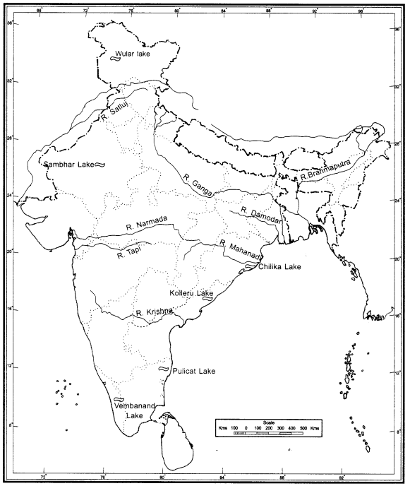
Map Skills
(i) On the outline map of India mark and label the following rivers: Ganga, Satluj, Damodar, Krishna, Narmada, Tapi, Mahanadi, and the Brahmaputra.
(ii) On an outline map of India mark and label the following lakes: Chilika, Sambhar, Wular, Pulicat, Kolleru.
Hope given NCERT Solutions for Class 9 Social Science Geography Chapter 3 are helpful to complete your homework.
If you have any doubts, please comment below. Learn Insta try to provide online tutoring for you.