Here we are providing Class 11 Geography Important Extra Questions and Answers Chapter 6 Soils. Important Questions for Class 11 Geography are the best resource for students which helps in class 11 board exams.
Important Questions for Class 11 Geography Chapter 6 Soils
Soils Important Extra Questions Very Short Answer Type
Question 1.
What is soil?
Answer:
Soil is a layer of unconsolidated material at the surface of the earth which has been derived from rocks and organic matter.
Question 2.
How is soil formed?
Answer:
It is formed by gradual disintegration under the influence of various agents.
Question 3.
Name the major factors in the formation of soils.
Answer:
Parent material, relief, climate, vegetation and drainage.
Question 4.
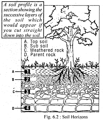
Name the three horizons of the soil.
Answer:
- A horizon – topmost
- B horizon – less leached
- C horizon – illuvial
Question 5.
Name the physical properties of the soil.
Answer:
Size, shape and arrangement of particles, the volume and effective depth of the soil.
Question 6.
What is ravine?
Answer:
It is a small narrow valley with steep sides. It is larger than a gully and smaller than a canyon.
Question 7.
Why soil conservation is important?
Answer:
Because it is the most important natural resource for plants, animals and human beings.
Question 8.
Define soil texture.
Answer:
Soil texture is the arrangement and relationship of particles of the soil.
Question 9.
What does the black colour of the soil indicate?
Answer:
It indicates the presence of rich organic matter in the soil.
Question 10.
What is meant by slight, moderate and severe erosion?
Answer:
If the soil erosion is less than 25% of the surface – light.
- If it is between 25%-75% – moderate.
- If it is more than 75% – severe.
Question 11.
Which organisms play an effective role in the fertility of the soil?
Answer:
These are bacteria, fungi, earthworms, ants and other insects and animals.
Question 12.
Which two groups the soils used to be classified into in ancient India?
Answer:
Urvara and Usara, meaning fertile and sterile respectively.
Question 13.
What does ICAR stand for?
Answer:
ICAR stands for Indian Council of Agricultural Research.
Question 14.
On which criteria, the ICAR classification is based?
Answer:
The ICAR classification is based on genesis, colour, composition and location.
Question 15.
Identify the various categories of soils in India as classified by ICAR.
Answer:
Alluvial soil, black soil, red and yellow soils, laterite soil, arid soils, saline soils, organic soil and forest soils.
Question 16.
What is Regur?
Answer:
‘Regur’ is black soil.
Question 17.
Which two types of soils have been developed in the upper and middle Ganga plain?
Answer:
Khadar and Bhangar. Khadar is a newer alluvial whereas Bhangar is older alluvial.
Question 18.
Give some examples of coarse grain.
Answer:
Jowar, Bajra, ragi, etc.
Question 19.
Which chemical is added to the soils in order to solve the problem of salinity?
Answer:
Gypsum is added to the soil in order to solve the problem of salinity.
Question 20.
What is ‘jumping’?
Answer:
‘Jumping’ is the name of shifting agriculture in India. This is the oldest type of agriculture. This is also known as ‘slash and bum’ method.
Question 21.
Which regions are known for cotton cultivation in India?
Answer:
The Deccan plateau and the Coimbatore upland are known for cotton cultivation in India.
Question 22.
Name the two most active agents of soil erosion.
Answer:
Wind and running water are the two active agents of soi 1 erosion.
Question 23.
What exhibits badland topography?
Answer:
Areas with poor vegetation and steep slope, particularly in undulating terrain and along with the river courses, often exhibit badland topography.
Question 24.
What are the ill effects of soil erosion?
Answer:
Ill effects of soil erosion are the removal of fertile soil, sudden and heavy floods, sitting of river beds, lowering of water bodies and lowering of the soil moisture.
Question 25.
Name three primary forms of soil structure.
Answer:
The three primary forms of soil structure are granular, blacky and peaty.
Question 26.
What are ferruginous gneiss and schist rocks?
Answer:
Time rocks containing iron are known as ferruginous gneiss and schist.
Question 27.
From which the black soil is derived?
Answer:
- Deccan trap and
- the ferruginous gneiss and schist rock.
Soils Important Extra Questions Short Answer Type
Question 1.
Explain how the soil organisms play an effective role in the fertility of the soil?
Answer:
A large number of soil organisms including bacteria, fungi, earthworms, ants, insects and animals play an effective role in the fertility of the soil. They multiply very quickly under favourable conditions and add nutrients to the soil.
Question 2.
How did the soils use to be classified in ancient India?
Answer:
In ancient India, the soils used to be classified into two main groups, viz., Urvara which were fertile and Usara which were sterile. The Urvara soils were subdivided into different types on the basis of crops grown, such as barley soil, rice soils, etc. Similarly, Usara soils were sub-divided into salt land, deserts, etc.
Question 3.
Discuss the types and characteristics of alluvial soils.
Answer:
Alluvial soils are depositional soils transported by the streams and winds. They are largely sandy loam in texture. The colour of the alluvial soils varies from light grey to ash grey. Its shades depend on the depth of the deposition, the texture of the materials, and the time taken for its formation.
Question 4.
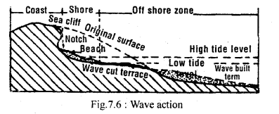
What are ravines? How are they different from gullies?
Answer:
A ravine is a small, narrow valley with steep sides, larger than a gully, but smaller than a canyon.
A gully, on the other hand, is a narrow channel worn in the earth by water. It is especially a miniature valley resulting from a heavy downpour of rain. Further erosion and deepening of a gully leading to the formation of a ravine.
Question 5.
Differentiate among soil erosion, soil exhaustion and soil degradation.
Answer:
The removal of the soil by running water in wet areas and wind in dry areas is known as soil erosion. The removal of its organic and mineral content is referred to as soil exhaustion. Whereas the misuse of the soils leads to soil degradation i.e. decline in the quality of soil, However, the agencies involved in soil erosion, exhaustion and degradation are common. They are running water, wind, snow, animals and human beings.
Question 6.
Which elements are required by plants as nutrients?
Answer:
A large number of elements namely, carbon, hydrogen, oxygen, nitrogen, phosphorus, potassium, sulphur, magnesium, calcium, iron, manganese, zinc, copper, boron and molybdenum are required by a plant as nutrients.
Question 7.
Classify the soil on the basis of various types of water in India.
Answer:
There are four types of soils identified on the basis of different types of water. They are Barani, Chari, Nahari and sailable. Soils dependent on rainwater are called Barani, that on well irrigation Chari, that on canal irrigation Nahari and that on river percolation sailable.
Question 8.
Define alluvium.
Answer:
The alluvium is the unconsolidated, loose material left only soil but also the gravel and sand brought down by a river and deposited in its bed, flood plain, delta or estuary, or in a lake, or land down like cone deposits on the flood plains of the large rivers.
Question 9.
Which type of soil is derived from Deccan lavas? Explain its important characteristics?
Answer:
Black soil is derived from Deccan lavas. The important characteristics are:
- It chemically consists of lime, iron, magnesia and alumina.
- It is generally clayey, deep and impermeable.
It lacks in phosphorous, nitrogen and organic matter but contains potash.
Question 10.
Which type of soil is the most dominant type and where is it found? Describe its two properties.
Answer:
Alluvial soils are the most widespread soil covering an area of 8 lakh sq. km. from Punjab to Assam. It is found over about 43.7% area in India. It is found in river basins, flood plains and coastal areas. This soil is rich in potash but poor in nitrogen. Alluvial soi Is are of three types:
- Khadar soils -f fine and deposited in flood plains.
- Bangar soils – older alluvium soil.
- Newest alluvial soils – fine alluvial soil found in delta.
Question 11.
What are the characteristics of laterite soils?
Answer:
- The laterite soils are brick coloured.
- These are shallow, acidic and less fertile.
- these less fertile due to leaching of soil.
- These are poor in nitrogen, potash but rich in iron. This is found in Tamil Nadu.
Question 12.
What is the parent material of soil?
Answer:
The soils are formed due to the weathering and erosion of rocks exposed on the surface. The material which has undergone weathering and erosion and had contributed to soil formation is known as the parent material. The type and nature of parent materials play a vital role in determining the properties of soil.
Question 13.
What is contour ploughing?
Answer:
The method of tilting or ploughing hillsides or sloping lands among the contour lines, that is, around rather than up and down a slope mainly with a view of conserving soil and water.
Question 14.
How can we improve the fertility of soils?
Answer:
The fertility of the soil means the presence of humus contents and enough soil nutrients which provides nourishment to the plants. To improve the fertility of the soil following methods should be used:
Question 15.
Distinguish between soil erosion and soil conservation.
Answer:
| Soil erosion | Soil conservation |
| (1) Ills black in colour and hence called black soil. | (1) It is yellow in colour. |
| (2) It is formed by the decomposition of lava. | (2) It is formed by leaching in tropical areas. |
| (3) It is suitable for the cultivation of cotton. | (3) It is suitable for millets. |
| (4) Et is found in Deccan plateau. | (4) It is found over a low plateau in Bihar. |
Soils Important Extra Questions Long Answer Type
Question 1.
Describe the areas affected by soil erosion. What are the factors responsible for it? Suggest measures to conserve it.
Answer:
The areas affected by the soil erosion are West Bengal, Uttar Pradesh, Madhya Pradesh, Maharashtra, Tamil Nadu, Karnataka, Delhi, Rajasthan and many other parts of India.
- Potato cultivation in theregionofMeghalayaonNilgiri hills causes soil erosion.
- Cleaning of forests in the Himalayas and on the Western Ghats.
- Excessivegrazingbycattleontheslopesofhillscauserapidsoil erosion.
- On steep slopes due to running water soil-erosion increases.
- Strong winds cause soil erosion. They blow away soil in dry areas.
- Heavy rainfall causes soil-erosion.
- Jumping by the tribal population in different parts of the country have caused considerable depletion of the soils.
- Deforestation causes soil erosion.
The followings are the measures to conserve the soils:
- By scientific use of land.
- Crop-rotation, contour ploughing and bunding.
- Afforestation in the upper reaches of river basins.
- Increased use of organic manures.
- Construction of water barriers against gullies in wet regions.
- Replacing flood irrigation by sprinklers and drip irrigation.
Question 2.
Write a short note on Arid soils and Saline soils.
Answer:
Arid soils – Arid soi 1 is red to brown in colour. They are generally sandy and alkaline. In some areas, the salt content is so high that common salt is obtained by evaporating the saline water. In a dry climate, due to high temperature and accelerated evaporation. They lack moisture and humus content is normal. Lower horizons of soils are occupied by Kankar due to increased calcium downward. This type of soil is found in Rajasthan where desert topography is found. These soils contain less humus and. organic matter. These are suitable for Jowar, Bajra, Ragi and oilseeds, etc.
Saline soils – These are known as Usara soils. It contains a larger portion of sodium, potassium and magnesium. It is poorly fertile. These require more salts largely because of the dry climate and poor drainage. These are found in arid and semi-arid regions and water-logged and swampy areas. Its structure ranges from sandy to loamy. It lacks nitrogen and calcium. Saline soils are found in the region of western Gujarat, deltas of the eastern coasts and Sunderban area of West Bengal. With the excessive use of cultivation and irrigation, the fertile alluvial soils are becoming saline.
Question 3.
Describe the major characteristics and distribution of the soils in India.
Answer:
Characteristics and distribution of soils in India:
1. Alluvial soil – It is fine silt deposited in the plains by rivers, brought from the mountain regions. It is very fertile and famous for agriculture. Relatively fine and new soil of the flood plains and deltas is known as Khadar and older deposits as Bangar. Great plains of the north and deltas of peninsular rivers abound in alluvial soil.
2. Black soil – Black soil is made of volcanic rocks of lava flows. The soil is fertile and clayey. It can maintain moisture for long periods. Due to black in colour, it is said to be black soil. Cotton is grown abundantly in this soil. Locally it is named as regur soil. Gujarat, parts of M.P. and Maharashtra have black soil over large areas.
3. Red soil – Red soil has developed on the crystalline igneous rocks. They are less fertile but with the help of manures and fertilisers, good crops are raised in it. Relatively hot and dry parts of southern and eastern peninsula abound in red soils.
4. Laterite soil – Due to heavy rains fertile portion of the soil has been washed away leading to leaching. Hence the soil is infertile. Hilly regions of Western Ghats and Chhotanagpur plateau with heavy rainfall and hot weather are represented by this type of soil.
5. Mountain soils are found in the Himalayan region. They are good for tea growing. Desert soil is found in Rajasthan. They are sandy and do not produce any significant crop.
Question 4.
Discuss the type of physical conditions leading to the formation of peaty and organic soils.
Answer:
The peaty and organic soils are found in the areas of heavy rainfall and high humidity, where there is a good growth of vegetation. A large amount of dead organic matter accumulates in these areas and this gives rich humus and organic content to the soil. Hence, they are peaty and organic soils. Organic matter in these soils may go even up to 40 to 50%.
These soils are normally heavy and black in colour. They occur widely in the northern part of Bihar, the southern part of Uttaranchal and coastal areas of West Bengal, Orissa and Tamil Nadu. Such soils are used for cultivation of high and less soil exhaustive crops.
Question 5.
(a) So long a balance exists between the processes of soils formation and soil erosion, there is no nutrient, but when the balance has distributed the erosion of the soil becomes a menace. Comment.
Answer:
The removal of soil by running water and the erosion process of running water and wind are continuous. Generally, there is a balance between these two processes. The rate of removal of fine particles from the surface is the same as the rate of addition of particles to the soil layer. Sometimes such a balance is distributed by natural or human factors, leading to a greater rate of removal of soil. When this happens, the entire soil layer may be removed in a few years.
Indiscriminate felling of trees, careless overgrazing of pasture lands, unscientific drainage operations and improper land use are some of the important causes which upset this balance.
(b) What are ravines? How are they different from gullies?
Answer:
Ravines: A ravine is a small narrow valley with steep sides, larger than a gully, but smaller than a canyon.
A gully, on the other hand, is a narrow channel worn in the earth by water. It is especially a miniature valley resulting from a heavy downpour of rain. Further erosion and deepening of a gully leading to the formation of a ravine.